
Innernzell
| coat of arms | Germany map | |
|---|---|---|

|
Coordinates: 48 ° 51 ' N , 13 ° 16' E |
|
| Basic data | ||
| State : | Bavaria | |
| Administrative region : | Lower Bavaria | |
| County : | Freyung-Grafenau | |
| Management Community : | Schoenberg | |
| Height : | 636 m above sea level NHN | |
| Area : | 22.13 km 2 | |
| Residents: | 1546 (Dec. 31, 2019) | |
| Population density : | 70 inhabitants per km 2 | |
| Postal code : | 94548 | |
| Primaries : | 08554, 09908 | |
| License plate : | FRG, GRA, WOS | |
| Community key : | 09 2 72 128 | |
| Community structure: | 19 districts | |
| Address of the municipal administration: |
Schulstr. 3 94548 Innernzell |
|
| Website : | ||
| Mayor : | Josef Kern ( CSU ) | |
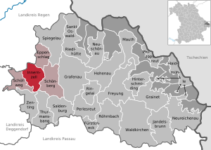
| Location of the municipality of Innernzell in the Freyung-Grafenau district | ||
  |
||

Innernzell is a municipality in the Lower Bavarian district of Freyung-Grafenau . The place of the same name is both the capital and the seat of the municipal administration.
geography
Geographical location
The municipality is located in the Danube Forest region in the Bavarian Forest . Innernzell is located on the B 533 around 14 km west of Grafenau , 23 km from the federal motorway 3 ( Hengersberg exit ) and 28 km from Deggendorf .
Neighboring communities
- Schöfweg
- Kirchberg im Wald ( Regen district )
- Kirchdorf im Wald ( Regen district )
- Eppenschlag
- Schönberg (Lower Bavaria)
- Thurmansbang
- Zenting
Community structure
There are 19 districts:
There are the districts of Gmünd, Hilgenreith and Innernzell.


history
Until the 19th century
In Urbar from Kloster Osterhofen is Cell mentioned 1,353th In 1395 the nobles von Hals owned three estates in Czell as fiefs of the Bishop of Passau. In 1471 the branch was raised to the status of vicariate of the parish Aicha vorm Wald . In the map of Philipp Apian from 1568 the place is entered as Iñera Zell . In 1578 the entire village, including the church, burned down.
In a description of the estates in the Bärnstein Regional Court in 1597, twelve Hofmark estates are mentioned as belonging to the Osterhofen Monastery, while the Tafern alone belonged to the Bärnstein Regional Court. A spacious parish was set up around 1600, which also looked after Schöfweg . In 1742, during the War of the Austrian Succession , Hungarian hussars looted the village.
Innernzell belonged to the Electorate of Bavaria to Rentamt Straubing and after the dissolution of the monastery Osterhofen the convent of St. Anna (Munich) . At the end of the 18th century, the women's monastery acquired both the estates of the Osterhofen monastery (landlords in Innernzell) and the Dachsberger Hofmark Ranfels (bailiwick). A ruling court assured by Elector Karl Theodor was revoked in 1802. In 1818 today's political community was established. In 1842 a new church was built in the classical style.
Incorporations
In 1945 or 1946, the entire previously independent municipality of Gmünd and part of Hilgenreith were incorporated. On January 1, 1972, part of the community of Solla was added.
Population development
Between 1988 and 2018 the population stagnated or increased minimally from 1,541 to 1,549 by 8 inhabitants or 0.5%.
- 1961: 1396 inhabitants
- 1970: 1530 inhabitants
- 1987: 1542 inhabitants
- 1991: 1602 inhabitants
- 1995: 1660 inhabitants
- 2000: 1701 inhabitants
- 2005: 1677 inhabitants
- 2010: 1621 inhabitants
- 2015: 1561 inhabitants
politics
The community is part of the Schönberg administrative community .
Municipal council
The local elections of 2020 and earlier resulted in the following distribution of seats (in brackets the votes obtained):
| CSU | Free voters | total | |
| 2020 | 6 (53.90%) | 6 (64.10%) | 12 |
| 2014 | 7 (61.97%) | 5 (38.03%) | 12 |
mayor
The honorary first mayor is Josef Kern ( CSU ), who was re-elected in the first round of the 2020 mayoral election with 53.9% of the valid votes. He has been in office since May 1, 1990. In the 2014 local elections, Kern was re-elected in the first ballot with 58.49% of the valid votes.
coat of arms
|
|
Blazon : " Slanted left divided by silver and blue, inside a sloping bishop's staff divided by red and gold, including three, one to two set golden balls." |
Architectural monuments
Soil monuments
Economy and Infrastructure
Companies
According to official statistics, there were no jobs subject to social insurance contributions in 1998 in the manufacturing industry 207 or in trade and transport; In other economic sectors, 117 jobs were subject to social security contributions. There were a total of 604 employees subject to social security contributions who lived in the municipality of Innernzell.
There were four companies in the manufacturing sector and five in the construction sector. In addition, in 1999 there were 63 farms with an agricultural area of 901 ha, of which 790 ha were permanent green space.
The main administrative location of Karl Bau GmbH is in Innernzell .
education
In 1999 the following institutions existed:
- Kindergartens: 75 kindergarten places with 82 children
- Elementary schools: one with 13 teachers and 194 students
See also
Web links
Individual evidence
- ↑ "Data 2" sheet, Statistical Report A1200C 202041 Population of the municipalities, districts and administrative districts 1st quarter 2020 (population based on the 2011 census) ( help ).
- ^ Community of Innernzell in the local database of the Bavarian State Library Online . Bayerische Staatsbibliothek, accessed on January 5, 2018.
- ^ Wilhelm Volkert (ed.): Handbook of Bavarian offices, communities and courts 1799–1980 . CH Beck, Munich 1983, ISBN 3-406-09669-7 , p. 473 .
- ↑ Local council election & mayoral election in Innernzell 2020 - candidates & results. In: Wahl.info. March 15, 2020, accessed June 13, 2020 .
- ↑ Mayor and councilors. Innernzell municipality, accessed on August 25, 2020 .
- ↑ Mayor / Lord Mayor in municipalities belonging to the district (as of May 1st, 2020). (xlsx) Bavarian State Office for Statistics, accessed on June 12, 2020 .
- ↑ Entry on the coat of arms of Innernzell in the database of the House of Bavarian History

Cities:
Freyung |
Grafenau |
Waldkirchen
Markets:
Perlesreut |
Röhrnbach |
Schönberg
municipalities:
Eppenschlag |
Fürsteneck |
Grainet |
Haidmühle |
Hinterschmiding |
Hohenau |
Innernzell |
Jandelsbrunn |
Mauth |
Neureichenau |
Neuschönau |
Philippsreut |
Ringelai |
Saldenburg |
Sankt Oswald-Riedlhütte |
Schöfweg |
Spiegelau |
Thurmansbang |
Zenting
municipality-free areas:
Annathaler Wald |
Frauenberger and Duschlberger Forest |
Grained forest |
Leopoldsreuter Forest |
Mauther Forest |
Philippsreuter Forest |
Pleckenstein Forest |
Saint Oswald |
Schlichtenberg Forest |
Schönbrunn Forest |
Waldhäuserwald