Perlesreut
| coat of arms | Germany map | |
|---|---|---|

|
Coordinates: 48 ° 47 ' N , 13 ° 27' E |
|
| Basic data | ||
| State : | Bavaria | |
| Administrative region : | Lower Bavaria | |
| County : | Freyung-Grafenau | |
| Management Community : | Perlesreut | |
| Height : | 546 m above sea level NHN | |
| Area : | 29.72 km 2 | |
| Residents: | 2929 (Dec. 31, 2019) | |
| Population density : | 99 inhabitants per km 2 | |
| Postal code : | 94157 | |
| Area code : | 08555 | |
| License plate : | FRG, GRA, WOS | |
| Community key : | 09 2 72 138 | |
| LOCODE : | DE PER | |
| Market structure: | 31 districts | |
Market administration address : |
Unterer Markt 3 94157 Perlesreut |
|
| Website : | ||
| Mayor : | Gerhard Poschinger ( CSU ) | |
| Location of the Perlesreut market in the Freyung-Grafenau district | ||
Perlesreut is a market in the Lower Bavarian district of Freyung-Grafenau and a member of the Perlesreut administrative community . Perlesreut is a state-approved resort . Until 1875 the spelling was Perlesreuth .
geography
Geographical location
The market is located in the Danube Forest region in the Bavarian Forest between the river valleys of the Ilz and Ohe. Perlesreut is twelve kilometers from Grafenau and Freyung , ten kilometers to the B 85 to Tittling , 25 km to the A 3 (exit Aicha vorm Wald ), 16 km to Waldkirchen and 30 km to Passau (via Fürsteneck ).
Neighboring communities
Community structure
There are 31 districts:
|
|
|
|
There are the districts Niederperlesreut, Perlesreut, Praßreut , Waldenreut, Haus im Wald , Heinrichsreit and Marchetsreut.
history
Until the church is planted
Perlesreut (h) has been the original parish for the surrounding area since at least 1150 . Between about 1250 and 1350 the market was laid out after the market uprising by the bishops of Passau, to whose bishopric Passau the place together with the surrounding compartment (originally the monastery Niedernburg ) belonged since the beginning of the 13th century. Because it was not located on one of the important trade routes to Bohemia, but rather acted as the domestic trade center of the compartment, the market remained relatively small. Fires in 1728, 1828, 1833 and 1874 destroyed part of the historical building fabric.
The market, which enjoyed extensive proprietary rights, was secularized in 1803 with most of the bishopric area in favor of Archduke Ferdinand of Tuscany and only fell to Bavaria in 1805. In the course of the administrative reforms in Bavaria , the municipality edict of 1818 created today's municipality, which was originally limited to the market town itself.
Territorial reform
On January 1, 1971, the previously independent municipality of Waldenreut was incorporated. Niederperlesreut was added on January 1, 1972 . On January 1, 1978, parts of the dissolved community of Haus im Wald followed with the towns of Bibereck, Rentenpoldenreuth and Scharrmühle, and on May 1, 1978 parts of the community of Kumreut .
The Perlesreut administrative community was formed on May 1, 1978 from the communities of Fürsteneck , Perlesreut and Ringelai . On January 1, 1994, the Ringelai community was released from the administrative community.
Population development
Between 1988 and 2018 the market grew from 2,675 to 2,876 by 201 inhabitants or 7.5%.
Population development in the municipality of Perlesreut, taking into account the incorporations:
| year | 1840 | 1871 | 1900 | 1925 | 1939 | 1950 | 1961 | 1970 | 1987 | 1991 | 1995 | 2000 | 2005 | 2010 | 2015 |
| Residents | 2015 | 2309 | 2318 | 2348 | 2471 | 3146 | 2395 | 2657 | 2686 | 2925 | 3021 | 3001 | 2976 | 2905 | 2871 |
Schmalzlerfest
Based on the history of snuff and its earlier economic importance for the market, the “Schmalzlerfest” is held in Perlesreut on the third weekend in July. The highlight of this festival is the Sunday snuff competition, already known nationwide through radio and television reports. Everyone can take part, whether they are already a snuff user or a newcomer, and even holidaymakers do not look bad. The Schmalzler Festival is accompanied by other attractions, e.g. B. framed a large horse market and helicopter tours.
politics
Market council
Since the local election on March 16, 2014, the municipal council has been composed as follows:
- Christian Free Voters Union (CFWU): 7 seats (47.8% of the vote)
- Christian Social Union in Bavaria (CSU): 7 seats (52.2% of the votes)
The turnout was 62.0%.
mayor
Gerhard Poschinger (CSU) has been the first mayor since 2019. Since 2002, his predecessor was Manfred Eibl (CFWU), who was elected in the 2008 local elections without an opponent with 92.62% of the valid votes. In the 2014 local elections, he was confirmed in office with 93.0% of the valid votes. In the state election on October 14, 2018 , he was elected to the Bavarian state parliament via the list of free voters in the constituency of Lower Bavaria .
Finances
In 2014, the municipal tax revenue amounted to € 1,626,000, of which € 461,000 was trade tax revenue (net).
coat of arms
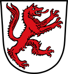
Blazon : "In silver, a left-facing, soaring, red wolf , both front paws raised."
Architectural monuments
Economy and Infrastructure
economy
According to official statistics, there were 198 employees at the place of work in the manufacturing sector and 89 in the trade and transport sector. In other areas of the economy 115 people were employed at the place of work subject to social security contributions. There were a total of 977 employees at the place of residence subject to social security contributions. There was one company in the manufacturing sector and seven companies in the construction sector. In 2007 there were 75 farms with a farm size of two hectares or more, which farmed an agricultural area of 1630 hectares; 387 ha of this was arable land and 1243 ha of permanent grassland.
education
The following institutions exist (as of 2015):
- In two day-care centers with a total of 91 approved places, 69 children are cared for and supported by a total of 16 people.
- In the primary school, 184 pupils are taught in 9 classes by 14 teachers (school year 2014/15).
Individual evidence
- ↑ "Data 2" sheet, Statistical Report A1200C 202041 Population of the municipalities, districts and administrative districts 1st quarter 2020 (population based on the 2011 census) ( help ).
- ↑ Bavarian State Statistical Office (Hrsg.): Historical municipality register: The population of the municipalities of Bavaria in the period from 1840 to 1952 (= contributions to Statistics Bavaria . Issue 192). Munich 1954, DNB 451478568 , p. 74–75 , urn : nbn: de: bvb: 12-bsb00066439-3 ( digitized version - Wolfstein district, footnote 6).
- ↑ Markt Perlesreuth in the local database of the Bayerische Landesbibliothek Online . Bayerische Staatsbibliothek, accessed on August 20, 2018.
- ^ Wilhelm Volkert (ed.): Handbook of Bavarian offices, communities and courts 1799–1980 . CH Beck, Munich 1983, ISBN 3-406-09669-7 , p. 596 .
- ^ Federal Statistical Office (ed.): Historical municipality directory for the Federal Republic of Germany. Name, border and key number changes in municipalities, counties and administrative districts from May 27, 1970 to December 31, 1982 . W. Kohlhammer GmbH, Stuttgart / Mainz 1983, ISBN 3-17-003263-1 , p. 627 and 628 .
- ↑ Fourth law to change the structure of municipalities and administrative communities of November 9, 1993 ( GVBl p. 830)
- ^ Database statistical data for Bavaria
Web links
- Entry on the coat of arms of Perlesreut in the database of the House of Bavarian History


