
Kumreut
|
Kumreut
Röhrnbach market
|
|
|---|---|
 |
|
| Height : | 523 m |
| Residents : | 421 (1987) |
| Incorporation : | May 1, 1978 |
| Postal code : | 94133 |
| Area code : | 08551 |
 Kumreut seen from the Geyersberg
|
|
Kumreut is a district of the Röhrnbach market in the Bavarian district of Freyung-Grafenau . Until 1875 the spelling was Kumreuth .
location
The parish village is located about seven kilometers southwest of the district town of Freyung and four kilometers north of Röhrnbach on federal highway 12 on a ridge between the Frei Bach in the west and the Breitwiesen Bach in the east at an altitude of 537 meters. A bypass has existed since the late 1990s, for which a 300-meter-long tunnel was built near Garham from 1995 to 1996.
history
Kumreut was first mentioned around 1200. The place belonged in the Hochstift Passau to the office Röhrnbach in the district court Leoprechting. The place was in 1803 with the largest part of the Passau area in favor of the Electorate of Salzburg by Ferdinand III. Secularized by Tuscany and fell to Bavaria in 1805 . With the formation of the municipalities in 1818 due to the second Bavarian municipality edict of 17 May 1818, the municipality Kumdorf was formed.
The Expositur Kumreut was created in 1906, the elevation to the parish took place in 1921. 1989 it counted 1484 Catholics. In 1905 the neo-Romanesque parish church of St. Josef was built . The Maria Traum pilgrimage chapel in Großwiesen, built in 1817, also belongs to the parish of Kumreut . In addition to the image of grace, it contains some popular images and figures along with an Arma-Christi cross .
Parts of the former communities of Harsdorf and Oberndorf were incorporated on January 1, 1970 and April 1, 1971.
On May 1, 1978, the majority of the municipality of Kumreut with Harsdorf and Oberndorf was incorporated into the Röhrnbach market as part of the regional reform in Bavaria , other parts came to the city of Freyung, to the Perlesreut market and a small part with just ten residents to the Ringelai municipality.
Culture and sights
Architectural monuments

The most striking building in Kumreut is the parish church of St. Josef . The building, which was built in the neo-Romanesque - Gothic style in 1905 and 1906 , is a landmark that can be seen from afar due to its slightly elevated position. In addition to the village of Kumreut, the parish of Kumreut also includes small and large meadows , Harsdorf , Rappmannsberg , Lobenstein , Stelzerreut and Lanzesberg , Ödhof , Ödmühle , Auggenthal , Prombach , Reisersberg , Öden , Mundobl , Neureut , Feldscheid and Garham . The church is now on the local list of monuments .
Immediately next to the church there is a memorial for the victims of the two world wars.
Also on the local list of monuments is a wayside shrine located on the road to Großwiesen in front of the Breitwiesenbach. This consists of a stone column with a lantern. Its origin is dated to the 18th or 19th century.
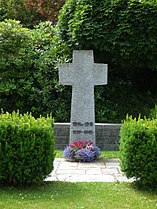
Cenotaph for the victims of the two world wars

graveyard

Green area at the church


societies
- Elderly Club Kumreut
- Kumreut Volunteer Fire Brigade , founded in 1898
- SV Kumreut
- Catholic Women's Association Kumreut
- Kumreuter singers
- Malteser Auxiliary Service Karlsbach-Kumreut
- Parish Caritas Association Kumreut e. V.
- Soldiers and Warriors League Kumreut
- VdK Kumreut
literature
- Alois Anderle among others: The Röhrnbach market in the past and present. Published by the market town of Röhrnbach. Röhrnbach 1990.
- Georg Drexler, Alois Anderle: The parish church of St. Joseph in Kumreut. Pp. 341-346.
- Georg Drexler, Alois Anderle: The school in Kumreut. Pp. 363-368.
- Paul Praxl : St. Maria Traum in Großwiesen. Pp. 349-352.
- Helmut Fastner: 100 years of the Kumreut volunteer fire department. With flag consecration. 1897 - 1997. Volunteer fire brigade, Kumreut 1998.
Web links
- Development of the place name Kumreut (PDF file; 77 kB)
- Kumreut Volunteer Fire Brigade
Footnotes and individual references
- ↑ Bavarian State Statistical Office (Hrsg.): Historical municipality register: The population of the municipalities of Bavaria in the period from 1840 to 1952 (= contributions to Statistics Bavaria . Issue 192). Munich 1954, DNB 451478568 , p. 74–75 , urn : nbn: de: bvb: 12-bsb00066439-3 ( digitized version - Wolfstein district, footnote 6).
- ^ Wilhelm Volkert (ed.): Handbook of Bavarian offices, communities and courts 1799–1980 . CH Beck, Munich 1983, ISBN 3-406-09669-7 , p. 595 .
- ^ Federal Statistical Office (ed.): Historical municipality directory for the Federal Republic of Germany. Name, border and key number changes in municipalities, counties and administrative districts from May 27, 1970 to December 31, 1982 . W. Kohlhammer GmbH, Stuttgart and Mainz 1983, ISBN 3-17-003263-1 , p. 628 .