
Röhrnbach
| coat of arms | Germany map | |
|---|---|---|

|
Coordinates: 48 ° 44 ' N , 13 ° 31' E |
|
| Basic data | ||
| State : | Bavaria | |
| Administrative region : | Lower Bavaria | |
| County : | Freyung-Grafenau | |
| Height : | 438 m above sea level NHN | |
| Area : | 40.63 km 2 | |
| Residents: | 4314 (Dec. 31, 2019) | |
| Population density : | 106 inhabitants per km 2 | |
| Postal code : | 94133 | |
| Primaries : | 08582, 08551 | |
| License plate : | FRG, GRA, WOS | |
| Community key : | 09 2 72 141 | |
| LOCODE : | DE RCH | |
| Market structure: | 44 districts | |
Market administration address : |
Rathausplatz 1 94133 Röhrnbach |
|
| Website : | ||
| Mayor : | Leonhard Meier (JBL) | |
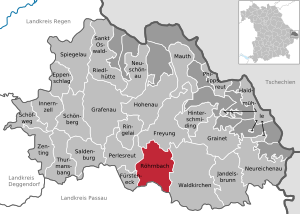
| Location of the Röhrnbach market in the Freyung-Grafenau district | ||
  |
||


Röhrnbach is a market in the Lower Bavarian district of Freyung-Grafenau and a state-approved resort .
geography
Geographical location
Röhrnbach is located in the Danube Forest region in the southern Bavarian Forest . The market is located on the B 12 , around 22 km north of Passau , eight kilometers west of Waldkirchen , twelve kilometers south of Freyung , 30 km from the Czech border near Philippsreut and 28 km from the Aicha vorm Wald exit from the BAB-3 away.
Neighboring communities
Districts
There are 44 districts:
climate
The actually rather harsh climate of the Bavarian Forest only applies to Röhrnbach to a limited extent, as it is below 500 meters in a protected valley basin.
history
Until the church is planted
The Röhrnbach, first mentioned in 1170, was located on the Bergreichensteiner branch of the Goldenen Steiges . As the golden path met Klafferstraße here , Röhrnbach was particularly important as a trading center in the 16th century. The place of the Hochstift Passau, which was raised to the market in 1612 (which enjoyed extensive rights of its own), had over 600 victims of the plague in 1649 .
The market town was secularized in 1803 with most of the Hochstiftischen area in favor of Archduke Ferdinand of Tuscany and only fell to Bavaria in 1805 . In the course of the administrative reforms in Bavaria, today's municipality was created with the municipal edict of 1818.
20th century
In the last days of the Second World War 42 houses were destroyed in Röhrnbach, plus 36 farm properties in the surrounding villages. From the reconstruction a rapid growth of the place arose, as a new branch of handicraft the glass processing came into the market.
In 1983 a new community center was built. From 1984 the bypass road was built.
Incorporations
Parts of the formerly independent communities Wilhelmsreut and Oberndorf were incorporated on April 1, 1971. The former community of Ausernbrünst was added on January 1, 1976. On May 1, 1978 part of the former municipality of Kumreut was incorporated . On March 1, 1979, an area of the district town of Freyung with the town of Kumreut with about 500 inhabitants was added.
Population development
Between 1988 and 2018 the market grew from 4,258 to 4,395 by 137 inhabitants or 3.2%.
|
|
politics
The market council consists of 16 members plus the mayor. The mayor is Leonhard Meier (Young Citizens List, JBL).
| Parties / voter communities |
% 2020 |
Seats 2020 |
% 2014 |
Seats 2014 |
% 2008 |
Seats 2009 |
% 2002 |
Seats 2002 |
|
| CSU | Christian-Social Union in Bavaria | 31.5 | 5 | 39.0 | 6th | 34.8 | 6th | 32.4 | 5 |
| CWG / FW | Christian voter community / Free Voters Bavaria | 19.2 | 3 | 24.8 | 4th | 23.7 | 4th | 21.6 | 4th |
| JBL | Young Citizens List | 21.9 | 4th | 15.5 | 3 | 17.6 | 3 | 17.2 | 3 |
| FWG | Free voter community Kumreut-Harsdorf | 11.7 | 2 | 11.7 | 2 | 13.0 | 2 | 13.3 | 2 |
| SPD / UW | SPD Bavaria / Independent voters | - | - | 9.1 | 1 | - | - | - | - |
| SPD / UW / ödp | SPD Bavaria / Independent voters / ÖDP | - | - | - | - | 10.8 | 1 | 15.5 | 2 |
| JL | Young list a church ... our home | 15.6 | 2 | - | - | - | - | - | - |
| total | 100.0 | 16 | 100.0 | 16 | 100.0 | 16 | 100.0 | 16 | |
| Voter turnout in% | 70.1 | 66.9 | 61.6 | 65.2 | |||||
- ↑ Rounding errors
coat of arms
The description of the coat of arms reads: In silver a red heart .
Culture and sights

Sights include the town center with the market square and the historic town houses. The community served as the backdrop in the TV series Forsthaus Falkenau , where the village was called Küblach . The late Baroque parish church of St. Michael was built between 1746 and 1750 on the tower walls of a late Gothic building. In 1970/71 the three-aisled vault building was extended.
In 1990, as part of the redesign of the market square, a granite fountain was set up at the location of the old fountain. The Munich sculptor Edmund Puchner won 1st prize in the competition with this fountain and hewn the fountain himself from Lower Bavarian granite. The granite disc with water dispenser placed on the fountain trough refers to the coat of arms of Markt Röhrnbach with the opening in the shape of a heart. The double-sided bull head reliefs symbolize the important cattle markets that used to take place in the community.
Architectural monuments
Economy and Infrastructure
Economy including agriculture and forestry
In 1998, according to official statistics, there were 28 people in the field of agriculture and forestry, 1,340 in the manufacturing sector and 140 people in the trade and transport sector at the place of work. In other economic areas, 100 people were employed at the place of work subject to social security contributions. There were a total of 1,438 employees at the place of residence subject to social security contributions. There were two companies in the manufacturing sector and eight in the construction sector. In addition, in 1999 there were 114 farms with an agricultural area of 2238 ha, of which 788 ha were arable land and 1448 ha were permanent green space.
traffic

Röhrnbach is connected to the regional road network with the federal highway 12 from Passau to Freyung / border crossing at Philippsreut .
Since 1890 there was a train station in Röhrnbach on the so-called Ilz Valley Railway from Passau to Freyung . In 1982 the regular passenger traffic was stopped. Freight trains and special trains ran on this route until August 2002. Since then, this route was no longer passable due to flood damage. From August 2009 to July 2011 the railway line was supported by the Ilztalbahn GmbH by the Förderverein Ilztalbahn e. V. made drivable again. On July 16, 2011, rail traffic was resumed as part of the Danube-Moldau leisure traffic project on Saturdays, Sundays and public holidays in the summer half-year and on special trips all year round.
education
The following institutions exist (as of 2017):
- three kindergartens: St. Michael Röhrnbach Kindergarten, Kumreut Kindergarten, Waldkirchen Waldkindergarten
- Elementary and middle school "Am Goldenen Steig" with 18 teachers and 150 students (school year 2016/17)
- Elementary school Kumreut with three teachers and 33 students (school year 2016/17)
Until 1970 there was also a primary school in Ausernbrünst.
Sports
SV Röhrnbach
At SV Röhrnbach there are football, volleyball, table tennis, skiing, chess, dance, stick shooting, kickboxing, archery, hiking enthusiasts, children's gymnastics, women's gymnastics, disabled sports, coronary clubs and that of castle jesters
Motor-Sport-Club Röhrnbach
The MSC Röhrnbach has around 230 members and comprises the following branches:
- Car racing: active in the regional and national rally - and autocross events as well as in mountain races represented
- Karting : Active in youth-Kart Slalom
- Motorcycle Racing : Successful Trial Sport and also the racetrack racing represented
Personalities
Born in Röhrnbach:
- Joseph Anton Meßmer (1829–1879), theologian and archaeologist
Born in Kleinwiesen:
- Georg Seibert (1939–2017), sculptor
Born in Ulrichsreuth:
- Erich Garhammer (* 1951), Roman Catholic theologian
Web links
- Official website of Markt Röhrnbach
- The area of the market town of Röhrnbach on: BayernAtlas of the Bavarian State Government ( notes )
- Entry on Röhrnbach's coat of arms in the database of the House of Bavarian History
Individual evidence
- ↑ "Data 2" sheet, Statistical Report A1200C 202041 Population of the municipalities, districts and administrative districts 1st quarter 2020 (population based on the 2011 census) ( help ).
- ↑ http://www.bayerische-landesbibliothek-online.de/orte/ortssuche_action.html ? Anzeige=voll&modus=automat&tempus=+20111214/192845&attr=OBJ&val= 662
- ^ Wilhelm Volkert (ed.): Handbook of Bavarian offices, communities and courts 1799–1980 . CH Beck, Munich 1983, ISBN 3-406-09669-7 , p. 596 .
- ^ Federal Statistical Office (ed.): Historical municipality directory for the Federal Republic of Germany. Name, border and key number changes in municipalities, counties and administrative districts from May 27, 1970 to December 31, 1982 . W. Kohlhammer GmbH, Stuttgart / Mainz 1983, ISBN 3-17-003263-1 , p. 627 and 628 .
- ↑ Announcement of the final result of the municipal council election on March 15, 2020. (pdf; 1.4 MB) In: marktroehrnbach.de. March 30, 2020, accessed July 10, 2020 .
- ↑ Result of the 2014 local elections
- ^ Result of the 2008 local elections
- ^ Result of the local elections in 2002

Cities:
Freyung |
Grafenau |
Waldkirchen
Markets:
Perlesreut |
Röhrnbach |
Schönberg
municipalities:
Eppenschlag |
Fürsteneck |
Grainet |
Haidmühle |
Hinterschmiding |
Hohenau |
Innernzell |
Jandelsbrunn |
Mauth |
Neureichenau |
Neuschönau |
Philippsreut |
Ringelai |
Saldenburg |
Sankt Oswald-Riedlhütte |
Schöfweg |
Spiegelau |
Thurmansbang |
Zenting
municipality-free areas:
Annathaler Wald |
Frauenberger and Duschlberger Forest |
Grained forest |
Leopoldsreuter Forest |
Mauther Forest |
Philippsreuter Forest |
Pleckenstein Forest |
Saint Oswald |
Schlichtenberg Forest |
Schönbrunn Forest |
Waldhäuserwald