
Hinterschmiding
| coat of arms | Germany map | |
|---|---|---|

|
Coordinates: 48 ° 49 ' N , 13 ° 36' E |
|
| Basic data | ||
| State : | Bavaria | |
| Administrative region : | Lower Bavaria | |
| County : | Freyung-Grafenau | |
| Management Community : | Hinterschmiding | |
| Height : | 737 m above sea level NHN | |
| Area : | 21.04 km 2 | |
| Residents: | 2425 (Dec. 31, 2019) | |
| Population density : | 115 inhabitants per km 2 | |
| Postal code : | 94146 | |
| Primaries : | 08551, 08550 | |
| License plate : | FRG, GRA, WOS | |
| Community key : | 09 2 72 126 | |
| LOCODE : | DE HCM | |
| Community structure: | 11 districts | |
| Address of the municipal administration: |
Dorfplatz 23 94146 Hinterschmiding |
|
| Website : | ||
| Mayor : | Fritz Raab (ÜWG) | |
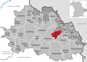
| Location of the Hinterschmiding community in the Freyung-Grafenau district | ||
  |
||


Hinterschmiding is a municipality in the Lower Bavarian district of Freyung-Grafenau and the seat of the Hinterschmiding administrative community . The place of the same name is also the main town and seat of the municipal administration and a state-approved resort .
geography
Geographical location
The community is located in the Danube Forest region in the Bavarian Forest west of the 1167 meter high Haidel . The village of Hinterschmiding is four kilometers east of Freyung , twelve kilometers from the border with the Czech Republic , 28 km from the border with Austria , 15 km north of Waldkirchen and 38 km from Passau .
Community structure
There are eleven districts:
|
There are the districts of Herzogsreut and Hinterschmiding.
Neighboring communities
history
Until the church is planted
The village in the former bishopric of Passau was first mentioned around 1400. It was located on the so-called Goldener Steig , on which salt was transported from the Danube port in Passau towards Bohemia. This found its way into the municipal coat of arms, on which a white horse loaded with a golden sack of salt can be seen. 1803 was the most of the high pin and the territory in favor of Ferdinand of Tuscany secularized ; it only fell to Bavaria in 1805 with the peace treaties of Brno and Pressburg. In 1818 Hinterschmiding became a political municipality and was given a free choice of mayor and municipal representatives.
20th century
In 1936 the place was raised to a parish. After the Second World War, an American prisoner of war camp, known as Camp Sonndorf , was set up in the community . After 1945 many expellees came to Hinterschmiding. From 1969 to 1970 the current parish church was built , the old church from 1927 was demolished.
Incorporations
On January 1, 1978, the municipality of Herzogsreut was incorporated into Hinterschmiding as part of the regional reform .
Population development
Between 1988 and 2018 the municipality grew from 2,174 to 2,443 by 269 inhabitants or by 12.4%.
- 1961: 1669 inhabitants
- 1970: 1937 inhabitants
- 1987: 2107 inhabitants
- 1991: 2314 inhabitants
- 1995: 2432 inhabitants
- 2000: 2513 inhabitants
- 2005: 2552 inhabitants
- 2010: 2534 inhabitants
- 2015: 2425 inhabitants
politics
Municipal council
Since the local elections on March 16, 2014, the municipal council has been composed as follows:
- ÜWG : 5 seats (34.83% of the votes)
- CSU : 5 seats (34.62% of the vote)
- FWG : 4 seats (30.55% of the votes)
mayor
The professional first mayor is Fritz Raab (non-partisan voter community). He took office on May 1, 2014.
coat of arms
|
|
Blazon : "In a red border, bepacktes with golden salt bag silver horse, including in gestürztem golden horseshoe a fallen golden sledgehammer." |
Partnerships
-
 Czech Republic : University Choir Ostrava
-
Czech Republic : North Moravian municipality of Bělotín (German: Bölten )
Economy and Infrastructure
Economy including agriculture and forestry
According to official statistics, there were 23 employees at the place of work in 1998 in the field of agriculture and forestry, 1806 in the manufacturing sector and 935 in the trade and transport sector. In other economic sectors, 479 people were employed at the place of work subject to social security contributions. There were a total of 4056 employees at the place of residence subject to social security contributions. There were three companies in the manufacturing sector and ten in the construction sector. In addition, in 1999 there were 99 farms with an agriculturally used area of 1753 hectares, of which 1370 hectares were arable land and 378 hectares were permanent green space.
education
In 2007 the following institutions existed:
- a kindergarten
- an elementary school with 14 teachers and 300 students
Culture
In Hinterschmiding, cultural life is cultivated in many ways, whether visual arts , literature or music , there is something for everyone, especially the partnership with the choir of the University of Ostrava brings highlights in the musical field again and again.
Architectural monuments
Soil monuments
literature
- Ernst Dorn : Herzogsreut, Philippsreut: Two pastoral care centers in the rear Bavarian Forest .
Web links
Individual evidence
- ↑ "Data 2" sheet, Statistical Report A1200C 202041 Population of the municipalities, districts and administrative districts 1st quarter 2020 (population based on the 2011 census) ( help ).
- ↑ a b Mayor / Lord Mayor in municipalities belonging to the district (as of May 1st, 2020). (xlsx) Bavarian State Office for Statistics, accessed on June 12, 2020 .
- ↑ Hinterschmiding community in the local database of the Bavarian State Library Online . Bavarian State Library, accessed on September 9, 2017.
- ^ Federal Statistical Office (ed.): Historical municipality directory for the Federal Republic of Germany. Name, border and key number changes in municipalities, counties and administrative districts from May 27, 1970 to December 31, 1982 . W. Kohlhammer GmbH, Stuttgart / Mainz 1983, ISBN 3-17-003263-1 , p. 628 .
- ↑ Entry on the Hinterschmiding coat of arms in the database of the House of Bavarian History
- ↑ See the private website about the former German municipality of Bölten: http://members.aon.at/boelten

Cities:
Freyung |
Grafenau |
Waldkirchen
Markets:
Perlesreut |
Röhrnbach |
Schönberg
municipalities:
Eppenschlag |
Fürsteneck |
Grainet |
Haidmühle |
Hinterschmiding |
Hohenau |
Innernzell |
Jandelsbrunn |
Mauth |
Neureichenau |
Neuschönau |
Philippsreut |
Ringelai |
Saldenburg |
Sankt Oswald-Riedlhütte |
Schöfweg |
Spiegelau |
Thurmansbang |
Zenting
municipality-free areas:
Annathaler Wald |
Frauenberger and Duschlberger Forest |
Grained forest |
Leopoldsreuter Forest |
Mauther Forest |
Philippsreuter Forest |
Pleckenstein Forest |
Saint Oswald |
Schlichtenberg Forest |
Schönbrunn Forest |
Waldhäuserwald