Schönberg (Lower Bavaria)
| coat of arms | Germany map | |
|---|---|---|

|
Coordinates: 48 ° 50 ' N , 13 ° 20' E |
|
| Basic data | ||
| State : | Bavaria | |
| Administrative region : | Lower Bavaria | |
| County : | Freyung-Grafenau | |
| Management Community : | Schoenberg | |
| Height : | 563 m above sea level NHN | |
| Area : | 32.74 km 2 | |
| Residents: | 3812 (Dec. 31, 2019) | |
| Population density : | 116 inhabitants per km 2 | |
| Postal code : | 94513 | |
| Area code : | 08554 | |
| License plate : | FRG, GRA, WOS | |
| Community key : | 09 2 72 147 | |
| LOCODE : | DE EON | |
| Market structure: | 40 districts | |
Market administration address : |
Marktplatz 16 94513 Schönberg |
|
| Website : | ||
| Mayor : | Martin Pichler ( CSU / Party-Free Citizens) | |
| Location of the Schönberg market in the Freyung-Grafenau district | ||

Schönberg is a market in the Lower Bavarian district of Freyung-Grafenau , the seat of the Schönberg administrative community and a state-approved climatic health resort .
geography
Geographical location
Schönberg is located in the Danube Forest region in the Bavarian Forest and is often referred to as the Merano of the Bavarian Forest due to its sunny location on a ridge with panoramic views at 564 meters above sea level . The market is also conveniently located at the intersection of the B 85 and the B 533 , although the place does not suffer from through traffic thanks to a wide bypass. After Passau is 38 km, to Tittling km 15, after Grafenau km 8, after Freyung km 25, after rain km also 25, after Deggendorf 33 km and A 3 (exit Hengersberg ) km 30th
Neighboring communities
Community structure
There are 40 districts:
There are the districts Eberhardsreuth, Hartmannsreit, Kirchberg, Mitternach, Schönberg, Großmisselberg and Innernzell.
climate
| Schönberg (Bavarian Forest) | ||||||||||||||||||||||||||||||||||||||||||||||||
|---|---|---|---|---|---|---|---|---|---|---|---|---|---|---|---|---|---|---|---|---|---|---|---|---|---|---|---|---|---|---|---|---|---|---|---|---|---|---|---|---|---|---|---|---|---|---|---|---|
| Climate diagram | ||||||||||||||||||||||||||||||||||||||||||||||||
| ||||||||||||||||||||||||||||||||||||||||||||||||
|
Average monthly temperatures for Schönberg (Bavarian Forest)
|
|||||||||||||||||||||||||||||||||||||||||||||||||||||||||||||||||||||||||||||||||||||||||||||||||||||||||
history
Until the 19th century
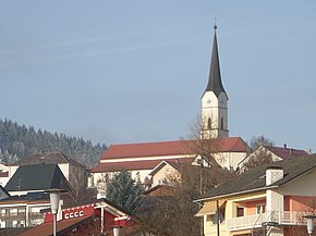
At the end of the 13th century Schoenberg received by the Counts of neck the market law . The Schönberg market belonged to the Straubing Rent Office and the Bärnstein Regional Court of the Electorate of Bavaria . Schönberg owned a market court with its own magistrate rights. Towards the end of the Thirty Years War , it was looted twice by Swedish troops in 1648. During the War of the Austrian Succession , the Pandours looted the place in 1742 . Since the Bavarian municipal edict of 1818 , Schönberg formed its own municipality. The neo-Gothic parish church of St. Margareta, whose predecessors go back to the 13th century, was built from 1836 to 1838.
20th and 21st centuries
Since Schönberg could not find a connection to a railway line, it was preferred in other respects: On July 1, 1908, the first motor mail car on the post motor car line Passau – Schönberg was welcomed. At first there were two trips a day in each direction. The yellow-painted postal buses had 35 hp and reached a speed of 15 km / h. Just two years later the line was extended to Grafenau.
Towards the end of the Second World War , the parish church and large parts of the market were destroyed.
On November 1, 1983, Schönberg received the title of a state-recognized health resort .
Incorporations
On December 28, 1946, the previously independent community of Mitternach and the smaller southern part of Großmisselberg were incorporated (the main part came to Eppenschlag). On January 1, 1971, as part of the regional reform, the Hartmannsreit community came to Schönberg. On May 1, 1978, the communities Eberhardsreuth and Kirchberg followed .
Population development
Between 1988 and 2018 the market grew from 3,648 to 3,841 by 193 inhabitants or by 5.3%.
- 1961: 3259 inhabitants
- 1970: 3519 inhabitants
- 1987: 3663 inhabitants
- 1991: 3869 inhabitants
- 1995: 4014 inhabitants
- 2000: 4092 inhabitants
- 2005: 3920 inhabitants
- 2010: 3804 inhabitants
- 2015: 3862 inhabitants
politics
mayor
Mayor is Martin Pichler (CSU / non-party citizens).
coat of arms
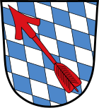
The Bavarian diamonds are marked with a slanted red arrow. Already in the oldest coat of arms from 1514, the diagonally right arrow appears between the Gothic letters “S” and “P” (Schön Perg), the origin of which is not known. With a document from 1537, the dukes Wilhelm and Ludwig confirmed the coat of arms for Schönberg.
Culture and sights
Museums
Picture gallery of the Bayerwaldkreis in the town hall.
Architectural monuments
Despite the war damage, the market square, which shows the Bavarian layout of a main street with a market extension, still shows the original orientation towards the Inn-Salzach style . The neo-Gothic parish church of St. Margareta dates back to the 13th century, but burned down several times. The current building from 1836 to 1838 was destroyed in the last days of the war in 1945, but then rebuilt.
The small church of St. John the Baptist in Kirchberg is a late Gothic complex on Romanesque foundation walls. The 30 m high observation tower on the Kadernberg, which has a climbing wall , is also worth seeing .
Economy and Infrastructure
The company Sesotec GmbH in the industrial area Saunstein is an important part of the economy of Schönberg . This company is one of the leading manufacturers of industrial metal detectors.
Economy including agriculture and forestry
In 1998 there were no employees subject to social insurance contributions at the place of work in the manufacturing industry or in trade and transport, according to official statistics. In other economic sectors 220 people were employed at the place of work subject to social security contributions. There were a total of 1332 employees at the place of residence subject to social security contributions. There were eight companies in the manufacturing sector and three in the construction sector. In addition, in 1999 there were 83 farms with an agricultural area of 1599 ha, of which 1259 ha were permanent green space.
traffic
- Road: Bundesstrasse 85 and Bundesstrasse 533 run through the municipality .
- Air traffic: Three kilometers south-east of the village is the special airfield at Elsenthal-Grafenau for aircraft up to 2000 kg maximum take-off weight (MTOW).
- Public transport : Schönberg is offered to the local public transport by buses of the RBO . The closest train station is Grafenau train station on the Zwiesel – Grafenau railway line .
education
There are the following institutions (as of 2018):
- Kindergartens: St. Elisabeth and forest kindergarten Buntspechte
- 140 kindergarten places (including crèche places for children under 3 years of age)
- Dietrich Bonhoeffer elementary and middle school
- open all-day care
literature
- The Freyung Grafenau district. Verlag Landkreis Freyung-Grafenau, Freyung 1982, ISBN 3-87553-192-2 .
- Petra Grond: Into the forest at 15 kilometers an hour. In: Der Bayerwald-Bote from July 1, 2008, number 151.
Individual evidence
- ↑ "Data 2" sheet, Statistical Report A1200C 202041 Population of the municipalities, districts and administrative districts 1st quarter 2020 (population based on the 2011 census) ( help ).
- ↑ bayerische-landesbibliothek-online.de
- ^ Wilhelm Volkert (ed.): Handbook of Bavarian offices, communities and courts 1799–1980 . CH Beck, Munich 1983, ISBN 3-406-09669-7 , p. 473 .
- ^ Federal Statistical Office (ed.): Historical municipality directory for the Federal Republic of Germany. Name, border and key number changes in municipalities, counties and administrative districts from May 27, 1970 to December 31, 1982 . W. Kohlhammer GmbH, Stuttgart / Mainz 1983, ISBN 3-17-003263-1 , p. 628 .
- ↑ Lookout tower on Kadernberg on bayerischer-wald.de
Web links
- http://www.schoenberg-bayerwald.de/
- Entry on the coat of arms of Schönberg (Lower Bavaria) in the database of the House of Bavarian History


