
Schöfweg
| coat of arms | Germany map | |
|---|---|---|

|
Coordinates: 48 ° 50 ' N , 13 ° 14' E |
|
| Basic data | ||
| State : | Bavaria | |
| Administrative region : | Lower Bavaria | |
| County : | Freyung-Grafenau | |
| Management Community : | Schoenberg | |
| Height : | 772 m above sea level NHN | |
| Area : | 19.03 km 2 | |
| Residents: | 1307 (Dec. 31, 2019) | |
| Population density : | 69 inhabitants per km 2 | |
| Postal code : | 94572 | |
| Area code : | 09908 | |
| License plate : | FRG, GRA, WOS | |
| Community key : | 09 2 72 145 | |
| Community structure: | 14 districts | |
| Association administration address: | Marktplatz 16 94513 Schönberg |
|
| Website : | ||
| Mayor : | Martin Geier ( Free Voters Schöfweg ) | |
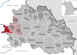
| Location of the municipality of Schöfweg in the Freyung-Grafenau district | ||
  |
||


Schöfweg is a municipality in the Lower Bavarian district of Freyung-Grafenau and a member of the Schönberg administrative community .
geography
Geographical location
The community is located in the Danube Forest planning region in the Bavarian Forest on the northern slope of the 1016 meter high Brotjacklriegel and bordering the Deggendorf district to the west and the Regen district to the north . Schöfweg is located on the B 533 around 20 km from the A 3 ( Hengersberg exit ), 25 km east of Deggendorf , 22 km south of Regen , 18 km west of Grafenau and 45 km north of Passau .
Community structure
There are 14 districts:
The districts Allhartsmais, Schöfweg and Hilgenreit exist .
Neighboring communities
- Hunding (Deggendorf district)
- Kirchberg im Wald (Regen district)
- Innernzell (Freyung-Grafenau district)
- Zenting (Freyung-Grafenau district)
- Schöllnach (Deggendorf district)
- Grattersdorf (Deggendorf district)
history
Until the church is planted
Schwefweg , an early possession of the bishopric of Passau , had in the Passauer arable twelve mid-13th century feudal out. In 1308 it came into the hands of Christian von Urleinsberg. In the Halser Salbuch it is mentioned in 1395 as Scheffweg and at that time it belonged again to the Hochstift. Later it was part of the Haingut Hofmark together with Hilgenreith and other villages .
In 1603, Duke Maximilian I bought the area as part of the winemaker rule . Schöfweg belonged to the Straubing Rent Office and the Diessenstein Regional Court of the Electorate of Bavaria . Around 1808 the exeremit Anton Franz Seraph Flurl built an emergency school in Schöfweg and in 1814 he built his own school house. In the course of the administrative reforms in Bavaria , today's municipality was created with the municipal edict of 1818 .
19th to 21st century
The school chapel was built in 1888/89 and, after a further expansion in 1947/48, today's parish church Maria, Mother of Sorrows, a massive granite building. Schöfweg, branch of Innernzell in 1915, has been a parish since 1921. In the years 1884, 1911 and 1913 severe fires struck Schöfweg. The Schöfweg Volunteer Fire Brigade was founded in 1877 . Another club is the Schöfweg 1970 e. V.
Allharts corn
The holiday resort Allhartsmais is a village with about 150 inhabitants. Allhartsmais is called Moas by the locals . They call themselves Moisinga themselves . The area around Allhartsmais was made arable by Abbot Adelhart von Rinchnach . Allhartsmais was named after him. "Mais" comes from maiseln , an old Bavarian word for "clearing". Accordingly, Allhartsmais translates into German as "Das von Adelhart cleared (village)".
Incorporations
In 1945 or 1946, the entire previously independent community of Allhartsmais ( Deggendorf district ) and part of Hilgenreit were incorporated. On April 1, 2013, large parts of the community-free area of Sonnenwald were incorporated.
Population development
Between 1988 and 2018, the community grew from 1,224 to 1,318 by 94 inhabitants or 7.7%.
- 1961: 1010 inhabitants
- 1970: 1132 inhabitants
- 1987: 1174 inhabitants
- 1991: 1319 inhabitants
- 1995: 1346 inhabitants
- 2000: 1344 inhabitants
- 2005: 1311 inhabitants
- 2010: 1301 inhabitants
- 2015: 1306 inhabitants
politics
mayor
Honorary first mayor Martin Geier (Free Voters Schöfweg). He has been in office since May 1, 2008 and was re-elected on March 15 in the 2020 mayoral election with 65.5%.
coat of arms
The description of the coat of arms reads: In blue from a sloping silver mountain of three, which is covered with a red sloping bar, growing a silver fir tree, fronted by a golden sun.
Architectural monuments
Economy and Infrastructure
Economy including agriculture and forestry
The municipal tax receipts in 1999 amounted to the equivalent of € 413,000, of which (net) € 14,000 were business tax receipts.
In 1998, according to official statistics, there were 74 employees in the manufacturing sector and 22 in trade and transport at the place of work. In other economic areas 39 people were employed at the place of work subject to social security contributions. There were a total of 441 employees at the place of residence subject to social insurance contributions. There were twelve companies in the manufacturing sector and one company in the main construction sector. In addition, in 1999 there were 52 agricultural holdings with an agriculturally used area of 458 hectares, 45 hectares of which were arable land and 413 hectares of permanent green area.
tourism
In winter there are three larger ski lifts in the municipality . Winter sports in the Sonnenwald near Langfurth are of particular importance .
education
There are the following facilities:
- Schöfweg primary school
- In 2005 the primary school was given up, it was assigned to the elementary school in Innernzell.
- Hedge educational trail: twelve-kilometer educational hiking trail near Allhartsmais
Sons and daughters of the church
- Joseph Lippl (1876–1935), Professor of the Old Testament in Regensburg
- Helga Weinberger (* 1953), member of the Bavarian State Parliament (CSU)
literature
- The district of Freyung-Grafenau , Freyung 1982, ISBN 3-87553-192-2
Individual evidence
- ↑ "Data 2" sheet, Statistical Report A1200C 202041 Population of the municipalities, districts and administrative districts 1st quarter 2020 (population based on the 2011 census) ( help ).
- ↑ a b Mayor / Lord Mayor in municipalities belonging to the district (as of May 1st, 2020). (xlsx) Bavarian State Office for Statistics, accessed on June 12, 2020 .
- ^ Community Schöfweg in the local database of the Bavarian State Library Online . Bayerische Staatsbibliothek, accessed on January 5, 2018.
- ^ Wilhelm Volkert (ed.): Handbook of Bavarian offices, communities and courts 1799–1980 . CH Beck, Munich 1983, ISBN 3-406-09669-7 , p. 473 .
- ↑ www.regierung.niederbayern.bayern.de
Web links
- Website of the community of Schöfweg
- Entry on Schöfweg's coat of arms in the database of the House of Bavarian History

Cities:
Freyung |
Grafenau |
Waldkirchen
Markets:
Perlesreut |
Röhrnbach |
Schönberg
municipalities:
Eppenschlag |
Fürsteneck |
Grainet |
Haidmühle |
Hinterschmiding |
Hohenau |
Innernzell |
Jandelsbrunn |
Mauth |
Neureichenau |
Neuschönau |
Philippsreut |
Ringelai |
Saldenburg |
Sankt Oswald-Riedlhütte |
Schöfweg |
Spiegelau |
Thurmansbang |
Zenting
municipality-free areas:
Annathaler Wald |
Frauenberger and Duschlberger Forest |
Grained forest |
Leopoldsreuter Forest |
Mauther Forest |
Philippsreuter Forest |
Pleckenstein Forest |
Saint Oswald |
Schlichtenberg Forest |
Schönbrunn Forest |
Waldhäuserwald