Grattersdorf
| coat of arms | Germany map | |
|---|---|---|

|
Coordinates: 48 ° 48 ' N , 13 ° 9' E |
|
| Basic data | ||
| State : | Bavaria | |
| Administrative region : | Lower Bavaria | |
| County : | Deggendorf | |
| Management Community : | Lalling | |
| Height : | 476 m above sea level NHN | |
| Area : | 25.98 km 2 | |
| Residents: | 1278 (Dec. 31, 2019) | |
| Population density : | 49 inhabitants per km 2 | |
| Postcodes : | 94541, 94551 | |
| Area code : | 09904 | |
| License plate : | DEG | |
| Community key : | 09 2 71 123 | |
| Address of the municipal administration: |
Auguste-Winkler-Str. 1 94541 Grattersdorf |
|
| Website : | ||
| Mayor : | Robert Schwankl ( CSU ) | |
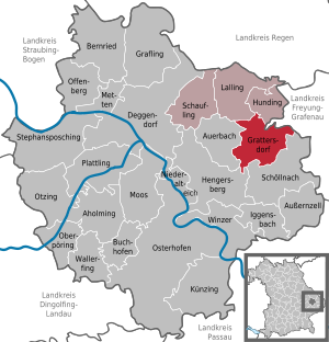
| Location of the municipality of Grattersdorf in the Deggendorf district | ||
Grattersdorf is a municipality in the Lower Bavarian district of Deggendorf and a member of the Lalling administrative community .
geography
The community is located in the Sonnenwald region.
The following districts exist : Grattersdorf, Nabin, Oberaign, Winsing.
The municipality includes 36 localities: Bärnöd, Büchelstein, Ebenöd, Eiserding, Ernading, Falkenacker, Frieberding, Friedenberg, Furth, Furthmühle, Gottsmannsdorf, Gern, Haselöd, Hatzenberg, Kerschbaum, Klemming, Konrading, Kralling, Kreuzerhof, Lanzing, Liebmannsberg, Lofering, Maging, Nabin, Neufang, Oberaign, Oitzing, Reigersberg (with the different postcodes 94551), Renzling, Roggersing , Spichting, Wangering, Wannersdorf, Weiking, Winsing, Würzing.
history
Until the founding of the forerunner churches
Grattersdorf was first mentioned in a document in 1209 when the brothers Ulrich and Poppo de Gradinsdorf were named as witnesses. The place Grattersdorf then belonged to the Counts of Hals . From 1451 he formed a closed Hofmark in the Electorate of Bavaria , whose seat was Grattersdorf.
After the Gradinsdorfer died out, the owners of the Hofmark were the lords of winemakers , who were followed in 1506 by the Puchbergers. In the map of Philipp Apian from 1568 the place is entered as Grederstorff . Veit von Puchberg had the church of St. Giles built here from 1536 to 1539. The 17th and 18th centuries brought several changes of ownership in Grattersdorf, most recently it belonged to the Barons of Vequel. Most of the other localities in today's municipality belonged to the Niederalteich monastery , partly to the Osterhofen monastery and Obermünster monastery . Around 1728 Grattersdorf received a school.
Community merger
In the course of the administrative reforms in Bavaria in 1818, the municipalities of Grattersdorf, Nabin, Oberaign and Winsing were formed, which were merged on January 1, 1971 to form the municipality of Grattersdorf.
Population development
In the period from 1988 to 2018, the number of inhabitants fell from 1,393 to 1,279 by 114 inhabitants or 8.2% - the clearest percentage decrease in the number of inhabitants in the district in the period mentioned.
- 1961: 1286 inhabitants, of which 649 in Winsing, 274 in Nabin, 222 in Grattersdorf and 141 in Oberaign
- 1970: 1305 inhabitants, 663 of them in Winsing, 288 in Nabin, 222 in Grattersdorf and 142 in Oberaign
- 1987: 1365 inhabitants
- 1991: 1422 inhabitants
- 1995: 1399 inhabitants
- 2000: 1411 inhabitants
- 2005: 1408 inhabitants
- 2010: 1346 inhabitants
- 2015: 1262 inhabitants
politics
Municipal council
The local elections of 2020 resulted in the following distribution of seats:
| CSU | FWG Grattersdorf |
FWG Roggersing |
total | |
| 2020 | 6th | 4th | 2 | 12 |
mayor
The first mayor since May 2020 is Robert Schwankl (CSU). In the local elections on March 15, 2020 , he was elected 1st mayor in the first ballot with 66.0 percent.
Mayor was Norbert Bayerl (CSU) from 2002 until his death at the end of October 2017. In 2002 he succeeded Josef Reitberger (CSU). Until the new elections on January 28, 2018, the second mayor, Alfons Gramalla, was in charge of official business and was elected first mayor with 79 percent.
coat of arms
| Blazon : "In blue a lowered, curled, silver tip, inside a red branch with four leaves, in front three turned away from each other, two to one placed silver crescent moons, behind a floating silver lily cross." | |
Architectural monuments
Soil monuments
Economy and Infrastructure
Economy including agriculture and forestry
In 1998, according to official statistics, there were no employees at the place of work in the manufacturing industry 31 and in the trade and transport sector. There were a total of 466 employees at the place of residence subject to social security contributions. There were three companies in the manufacturing sector and two in the construction sector. In addition, in 1999 there were 90 farms with an agriculturally used area of 943 ha, of which 285 ha were arable land and 657 ha were permanent green space.
education
In 2005 the following institutions existed:
- Kindergartens: 50 kindergarten places with 36 children
Web links
Individual evidence
- ↑ "Data 2" sheet, Statistical Report A1200C 202041 Population of the municipalities, districts and administrative districts 1st quarter 2020 (population based on the 2011 census) ( help ).
- ^ Wilhelm Volkert (ed.): Handbook of Bavarian offices, communities and courts 1799–1980 . CH Beck, Munich 1983, ISBN 3-406-09669-7 , p. 445 .
- ↑ Announcement of the final result of the election of the municipal council on March 15, 2020. In: grattersdorf.de. March 26, 2020, accessed May 2, 2020 .
- ^ Election result of March 15, 2020. wahl.info, March 16, 2020, accessed on March 16, 2020 .
- ↑ PNP news blog: Alfons Gramalla wins mayoral election. PNP , January 28, 2018, accessed January 30, 2018 .
- ^ Entry on the coat of arms of Grattersdorf in the database of the House of Bavarian History


