
Stephansposching
| coat of arms | Germany map | |
|---|---|---|

|
Coordinates: 48 ° 49 ' N , 12 ° 48' E |
|
| Basic data | ||
| State : | Bavaria | |
| Administrative region : | Lower Bavaria | |
| County : | Deggendorf | |
| Height : | 325 m above sea level NHN | |
| Area : | 44.68 km 2 | |
| Residents: | 3090 (Dec. 31, 2019) | |
| Population density : | 69 inhabitants per km 2 | |
| Postal code : | 94569 | |
| Primaries : | 09935, 09931 | |
| License plate : | DEG | |
| Community key : | 09 2 71 151 | |
| Address of the municipal administration: |
Deggendorfer Str. 6 94569 Stephansposching |
|
| Website : | ||
| Mayoress : | Jutta Staudinger ( CSU ) | |
| Location of the Stephansposching community in the Deggendorf district | ||
  |
||

Stephansposching is a municipality in the Lower Bavarian district of Deggendorf .
geography
location
The community is located south of the Danube in the Gäuboden .
Parish parts

The community is divided into 20 officially named community parts:
|
history
The oldest local settlement from the second half of the 6th millennium BC belongs to the culture of line ceramic . It is documented by extensive excavations. The name of the real ing place comes from the time of the Bavarians . In the year 790 Pasuhhinga is mentioned in the Breviarium Urolfi of Niederaltaich Monastery , although this may not mean Stephansposching, but Mariaposching .
The place got its final name when it came into the possession of the cathedral monastery Passau , whose cathedral patron is Saint Stephen. Waltherus de Poschingen around 1155 is the first known Passau Ministeriale in Stephansposching. In 1216 Stephansposching was in the hands of the Counts von Bogen , who documented that they received this property from the Bishop of Passau as a fief. After the Counts of Bogen died out in 1242, the property passed to the Lords of Degenberg . After their extinction in 1602, the closed Hofmark was acquired by the Bavarian duke in 1606. It was located in the area of the Natternberg court and remained a sovereign property until the reorganization in the 19th century.
In the course of the municipal edicts, the Stephansposching tax district was formed from the former chairman and other former chairmen , from which the Stephansposching community emerged. The current community was created on May 1, 1978 through the merger of the previous communities Michaelsbuch and Rottersdorf.
Population development
In the period from 1988 to 2018, the municipality grew from 2,568 to 3,176 by 608 inhabitants or 23.7%.
politics
Mayor
The 1st mayor is Jutta Staudinger (CSU), who was elected on March 30, 2014 with 53.95% of the valid votes cast. In the local elections on March 15, 2020 , Staudinger was re-elected with 90.8 percent unopposed candidate. Your predecessor was Siegfried Ramsauer (CSU). 2nd mayor is Anton Hafner (FWG).
Municipal council
The values reflect the distribution of seats (in brackets the percentage election result):
| CSU | FWG | SPD | UBS | AGL | total | |
| 2020 | 7 (44.08%) | 4 (24.07%) | 3 (19.05%) | 2 (12.8%) | - | 16 |
| 2014 | 5 (31.25%) | 4 (25%) | 3 (18.75%) | 2 (12.5%) | 2 (12.5%) | 16 |
coat of arms
|
|
Blazon : "In gold, a three-pronged cap with a silver cuff, on the right by a red ear and on the left by a green beech branch with three leaves."
The coat of arms has been used since 1982. |
Partner communities
Since August 7, 1991 there has been a local partnership with the community of Glaubitz in the district of Meißen in Saxony . In the partnership agreement it says: The partnership aims to bring the citizens of both communities together on a broad basis and to connect them on a friendly basis. It should be a common endeavor to extend the friendship ties that have been made to all areas of life that are suitable for this purpose.
Personalities
- Therese Frohnhöfer (1908–1987), farmer and politician
Attractions

The Via Danubia cycle path leads through the municipality of Stephansposching . In the district of Stephansposching, there was one of the last yaw ferries on the Bavarian Danube, the Danube ferry Mariaposching – Stephansposching , which, in addition to many cyclists, also transported cars and trucks in summer. It led to the opposite Mariaposching and made excursions into the Bavarian Forest , to Metten or to the Bogenberg near Bogen possible . After an accident in April 2016, operations were stopped. A replacement motor ferry was launched in Remagen on December 6, 2018 .
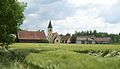
The Stephansposching parish church, which belongs to the Stephansposching-Michaelsbuch parish, is also centrally located.
The district of Stephansposching is rich in grave and skeleton finds from the Neolithic , which go back to the 6th millennium BC. In 2008 the discovery of a circular moat was announced. Other parts of Stephansposching's municipality are also archaeologically significant.
Others
On the eastern edge of the municipality, just before the Natternberg , is the Deggendorf airfield with a restaurant.
photos

Stephansposching from the north, the former mill in front
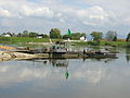
Stephansposching: yaw ferry
Bergham: view from the north

Snow-covered Stephansposching

Stephansposching from the west, in the background the Südzucker Plattling chimney


Aerial photographs of Stephansposching (August 2009)


literature
- Via Danubia, cycling in the footsteps of the Romans , Hohenwart 2001 (Galli Verlag)
- A picture journey through the district of Deggendorf , ed. from the Deggendorf District Office, 2002, ISBN 3-00-008866-0
- Dieter Vogel (Ed.): The Gäuboden, Heimatbuch , Vilsbiburg 1996, ISBN 3-9804048-2-X
- Klaus Rose : Deggendorf . Historical Atlas of Bavaria I / XXVII, Munich 1971 ( digitized version )
Individual evidence
- ↑ "Data 2" sheet, Statistical Report A1200C 202041 Population of the municipalities, districts and administrative districts 1st quarter 2020 (population based on the 2011 census) ( help ).
- ^ Community Stephansposching in the local database of the Bayerische Landesbibliothek Online . Bayerische Staatsbibliothek, accessed on December 5, 2017.
- ^ Federal Statistical Office (ed.): Historical municipality directory for the Federal Republic of Germany. Name, border and key number changes in municipalities, counties and administrative districts from May 27, 1970 to December 31, 1982 . W. Kohlhammer GmbH, Stuttgart / Mainz 1983, ISBN 3-17-003263-1 , p. 605 .
- ^ Election result of March 15, 2020. wahl.info, March 16, 2020, accessed on March 16, 2020 .
- ↑ Local council election & mayoral election in Stephansposching 2020 - candidates & results. In: Wahl.info. March 15, 2020, accessed May 3, 2020 .
- ↑ Entry on Stephansposching's coat of arms in the database of the House of Bavarian History , accessed on August 26, 2020 .
- ↑ 725 Years Glaubitz 1271 - 1996 Festschrift, p. 15.
- ↑ chh: Finally: The Danube ferry “Posching” is swimming. pnp.de, December 6, 2018, accessed December 7, 2018 .
Web links
- Stephansposching community
- Stephansposching in the location database of the Bavarian State Library Online
- Entry on the coat of arms of Stephansposching in the database of the House of Bavarian History
- Stephansposching: Official statistics of the LfStat
- Hofmark Stephansposching in the Historical Atlas of Bavaria

Aholming | Auerbach | Ausernzell | Bernried | Buchhofen | Deggendorf | Grafling | Grattersdorf | Hengersberg | Hunding | Iggensbach | Künzing | Lalling | Metten | Moss | Niederalteich | Oberpöring | Offenberg | Osterhofen | Otzing | Plattling | Shovel | Schöllnach | Stephansposching | Wallerfing | Winemaker