Via Danubia
| Via Danubia | |
|---|---|
| overall length | approx. 220 |
| map | |
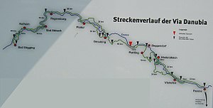
| Route of the Via Danubia between Bad Gögging and Passau | |
| Starting point | Gunzburg |
| Target point | Passau |
Via Danubia is the name of a long-distance cycle path in Bavaria along the Danube . The Via Danubia between Bad Gögging and Passau has existed since May 20, 2001. In 2006 a new section of the route between Günzburg and Oberndorf am Lech was opened. As a river cycle route, the Via Danubia is part of the transnational Danube Cycle Path .

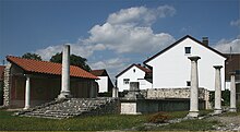
A Roman gate in Regensburg, the Porta praetoria , which gives the Via Danubia an antique flair.

The map section shows how the Via Danubia and the Upper German-Raetian Limes are related.
The Via Danubia (along the Danube) and the Limes (north of it) run more or less parallel for a long distance. They meet shortly before Regensburg and become almost identical.
The Via Danubia (along the Danube) and the Limes (north of it) run more or less parallel for a long distance. They meet shortly before Regensburg and become almost identical.
Traces of the Romans along the routes
The Latin name Via Danubia is reminiscent of Roman history and culture, the evidence of which appears again and again along the way (from Latin via - "way"; Danubius - "Danube", after the male river deity Danuvius ). Along the way, information boards provide information about historical events :
Between Günzburg and Oberndorf
- Günzburg - Guntia Roman military camp
- Offingen - is on the Roman Danube south road
- Gundelfingen - Roman milestone in the parish church
- Faimingen - open-air museum around the Apollo-Grannus temple as the "highlight" of the route
- Gundremmingen - Roman camp, so-called Bürgle
- Aislingen - Roman fort
- Holzheim -Ellerbach - Roman burial ground
- Wertingen - Roggden - Roman burial ground
- Buttenwiesen - Roman lookout point on the Thürlesberg
- Burghöfe (Mertingen) - Roman fort, end of the Via Claudia Augusta
- Oberndorf - traces of Roman settlement
Between Bad Gögging and Passau
- Bad Gögging - Roman baths in Bad Gögging
- Eining - Roman military in Eining
- Regensburg - Castra Regina , the Roman Regensburg
- Donaustauf - Roman viticulture on the Danube
- Rinkam - Via as a long-distance trade route
- Straubing Zoo - history of the city of Straubing until 1218
- Straubing St. Peter - Roman history of the city of Straubing
- Aiterhofen - Roman manors - villae rusticae
- Wischlburg - Early medieval "Römerschanze" Wischlburg
- Steinkirchen - Roman fort Steinkirchen
- Natternberg - prehistoric hilltop settlement and castle complex Natternberg
- Moos -Burgstall - Roman fort with civil settlement Moos-Burgstall
- Haardorf - Early Roman military station Haardorf
- Thundorf - Archeology of the community of Künzing , Museum Quintana in Künzing, Brick Museum in Flintsbach,
- Vilshofen on the Danube Road and bridge construction by the Romans
- Windorf - The Danube Limes between Künzing and Passau
- Passau - Roman history of the city of Passau
Course of the Via Danubia between Bad Gögging and Passau
- Bad Gögging to Regensburg 52 km
- Regensburg to Straubing 56 km
- Straubing to Plattling 46 km
- Plattling to Passau 62 km
Connectivity
- The Isar cycle path meets the Via Danubia in Deggendorf.
- The Inn Cycle Path and the Tauern Cycle Path connect in Passau with the Via Danubia.
- The German Limes Cycle Path , which meets the Via Danubia near Kelheim, can also be thematically continued; he also takes up the Roman heritage.
- The Via Claudia Augusta cycle path, which is also inspired by the Romans, meets the Via Danubia in Mertingen .
- The Danube Cycle Path in Baden-Württemberg , which leads from the source of the Danube to Bavaria, is the feeder from the west.
- The Danube Cycle Path, which leads east to Austria and on to the Danube Delta near Passau , is the continuation of the Via Danubia downstream.
cards
- Bavaria network for cyclists , cycle network map on a scale of 1: 625,000 based on the overview map of Bavaria 1: 500,000, ed. from the Bavarian State Ministry of the Interior, Ministry of Economics, Infrastructure, Transport and Technology , Munich 2005, ISBN 3-910088-95-3


