
Aislingen
| coat of arms | Germany map | |
|---|---|---|

|
Coordinates: 48 ° 31 ' N , 10 ° 28' E |
|
| Basic data | ||
| State : | Bavaria | |
| Administrative region : | Swabia | |
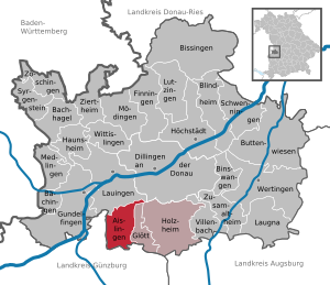
| County : | Dillingen on the Danube | |
| Management Community : | Holzheim | |
| Height : | 433 m above sea level NHN | |
| Area : | 19.35 km 2 | |
| Residents: | 1305 (Dec. 31, 2019) | |
| Population density : | 67 inhabitants per km 2 | |
| Postal code : | 89344 | |
| Area code : | 09075 | |
| License plate : | DLG, WHO | |
| Community key : | 09 7 73 111 | |
| LOCODE : | DE ALI | |
| Market structure: | 4 parts of the community | |
| Association administration address: | Hochstiftstr. 2 89438 Holzheim |
|
| Website : | ||
| Mayor : | Jürgen Kopriva ( Independent Community of Voters ) | |
| Location of the Aislingen market in the Dillingen district on the Danube | ||
  |
||

Aislingen is a market in the Swabian district of Dillingen on the Danube and a member of the Holzheim administrative community .
geography
At the exit of the Aislinger Bach from the Iller-Lech-Platte, part of the Donau-Iller-Lech-Platte , the Aislingen market expands. The city of Lauingen is seven kilometers away.
The municipality has four officially named municipal parts (the type of settlement is given in brackets ):
- Aislingen (main town)
- Baumgarten ( Kirchdorf )
- Rieder ( village )
- Windhausen (village)
The four places also form the four demarcations that exist in the municipality.
history
Until the church is planted
Finds prove a prehistoric settlement.
On the southern heights there was a Roman earth fort , built under the emperor Tiberius , which was destroyed around 68/69 AD. A Roman camp village was excavated nearby in 1989/90. A Roman road ran for around three kilometers along today's western boundary, which branched off from the Roman road Augsburg / Oberhausen- Günzburg at Haldenwang and led to Faimingen .
A double ski jumping facility on the Sebastiansberg probably dates from the first half of the 10th century. Row grave finds indicate that Aislingen is probably an Alemannic foundation. The first documented mention of it as "Eigislinga" dates back to 1063.
Aislingen was the seat of a noble family who named themselves after the place as Lords of Aislingen. The rule of Aislingen came to the Margraves of Burgau and finally from 1291 to 1489 to the Counts of Werdenberg . When the place was raised to the market cannot be proven. The Lords of Westernach and the Lords of Eggenthal were also wealthy in Aislingen . The seat of rule was a castle, which was demolished in 1860. In 1489 the Counts of Werdenberg sold their estates in Aislingen to the Augsburg bishopric , which established a nursing office in Aislingen . Since the Reichsdeputationshauptschluss of 1803, the place has belonged to Bavaria and was assigned to the newly formed Dillingen district court .
Incorporations
On May 1, 1978, the previously independent community of Baumgarten was incorporated.
Population development
- 1961: 1324 inhabitants
- 1970: 1323 inhabitants
- 1987: 1395 inhabitants
- 1991: 1348 inhabitants
- 1995: 1384 inhabitants
- 2000: 1374 inhabitants
- 2005: 1407 inhabitants
- 2010: 1352 inhabitants
- 2015: 1307 inhabitants
Between 1988 and 2018 the population fell from 1,368 to 1,299 by 69 inhabitants or 5%.
Religions
Aislingen is the seat of an old parish with the patronage of St. Georg . Today belongs to the parish Baumgarten, Rieder and Windhausen. Today's parish church of St. Georg was built in the core in the second half of the 15th century. Balthasar Suiter rebuilt the choir and the nave from 1736 to 1738 .
politics
Market council
The municipal council has twelve members. Since the 2014 local elections, the seats have been divided into the following lists:
- Independent constituency: 9 seats
- Free electoral association: 3 seats
mayor
Jürgen Kopriva (UWG) has been mayor since 2008; he was confirmed in office on March 15, 2020 with 56.7% for a further six years.
coat of arms
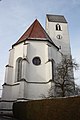
The description of the coat of arms reads: Split of red and silver; in front on a green mountain a silver chapel with a domed roof and lantern, behind a three-lobed, golden fringed red storm flag on three golden rings.
The coat of arms shows the landmark of the place in the front half of the shield, which is dedicated to St. Sebastian Chapel, a pentagonal central building from 1629/30. The three-lobed, golden fringed storm flag, the so-called Gonfanon, is the coat of arms of the Counts of Werdenberg. They were landlords in Aislingen from 1280 to 1489. During their local rule, Aislingen was elevated to market status in the 14th century. In 1489 the counts sold their estates in Aislingen to the bishopric of Augsburg, which owned it until the 19th century. This is reminiscent of the colors red and silver from the Augsburg monastery coat of arms.
Attractions
- Catholic parish church St. Georg in Aislingen
- Catholic branch church St. Margareta in Aislingen
- Catholic chapel St. Sebastian in Aislingen
- Catholic branch church St. Leonhard in Baumgarten
- Catholic chapel St. Isidor in Rieder

St. Georg (Aislingen)
St. Margareta (Aislingen)

St. Leonhard (Baumgarten)

St. Isidor (Rieder)


Economy and Infrastructure
Economy including agriculture and forestry
In 2014 there were 164 jobs subject to social security contributions in the village, 116 of them in manufacturing, 18 with public and private service providers and 9 with corporate service providers. Of the resident population, 571 people had an employment relationship subject to social security contributions. The number of out-commuters outnumbered the in-commuters by 407. In 2010 there were 46 farms. 1461 hectares of the municipality were used for agriculture, of which 1272 hectares were used as arable land.
Aislingen is the seat of the agricultural machinery manufacturer Kerner, which was founded in 1990 .
education
- There is a kindergarten with 50 places.
literature
- Georg Wörishofer, Alfred Sigg, Reinhard H. Seitz: Cities, Markets and Communities . In: The district of Dillingen ad Donau in the past and present . Edited by the district of Dillingen ad Donau, 3rd revised edition, Dillingen an der Donau 2005, pp. 127–133
Web links
- Homepage
- Entry on the coat of arms of Aislingen in the database of the House of Bavarian History
Individual evidence
- ↑ "Data 2" sheet, Statistical Report A1200C 202041 Population of the municipalities, districts and administrative districts 1st quarter 2020 (population based on the 2011 census) ( help ).
- ↑ Marktgemeinde Aislingen: Local council. Retrieved May 13, 2020 .
- ^ Aislingen community in the local database of the Bavarian State Library Online . Bayerische Staatsbibliothek, accessed on August 31, 2019.
- ↑ a b c Federal Statistical Office (ed.): Historical municipality directory for the Federal Republic of Germany. Name, border and key number changes in municipalities, counties and administrative districts from May 27, 1970 to December 31, 1982 . W. Kohlhammer, Stuttgart / Mainz 1983, ISBN 3-17-003263-1 , p. 770 .
- ↑ Description and history of the coat of arms on the website of the House of Bavarian History
- ↑ http://www.kerner-maschinenbau.de/

Aislingen | Bachhagel | Bächingen an der Brenz | Binswangen | Bissingen | Blind home | Buttenwiesen | Dillingen on the Danube | Finningen | Glött | Gundelfingen an der Donau | Haunsheim | Höchstädt on the Danube | Holzheim | Laugna | Lauingen | Lutzingen | Medlingen | Mödingen | Schwenningen | Syrgenstein | Villenbach | Wertingen | Wittislingen | Ziertheim | Zöschingen | Zusamaltheim