Aiterhofen
| coat of arms | Germany map | |
|---|---|---|

|
Coordinates: 48 ° 51 ' N , 12 ° 37' E |
|
| Basic data | ||
| State : | Bavaria | |
| Administrative region : | Lower Bavaria | |
| County : | Straubing arch | |
| Management Community : | Aiterhofen | |
| Height : | 339 m above sea level NHN | |
| Area : | 43.09 km 2 | |
| Residents: | 3378 (Dec. 31, 2019) | |
| Population density : | 78 inhabitants per km 2 | |
| Postal code : | 94330 | |
| Area code : | 09421 | |
| License plate : | SR , BOG, MAL | |
| Community key : | 09 2 78 113 | |
| LOCODE : | DE AIQ | |
| Community structure: | 16 districts | |
| Address of the municipal administration: |
Straubinger Str. 4 94330 Aiterhofen |
|
| Website : | ||
| Mayor : | Adalbert Hösl (CSU) | |
| Location of the municipality of Aiterhofen in the Straubing-Bogen district | ||
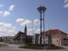
Aiterhofen is a municipality , a district and a parish village in the Lower Bavarian district of Straubing-Bogen and the seat of the administrative community of Aiterhofen .
geography
location
Aiterhofen lies in the Gäuboden and is traversed by the Aiterach .
Community structure
The municipality has 16 districts (municipality parts):
|
Markings
There are the districts of Aiterhofen, Amselfing, Geltolfing and Niederharthausen.
history
Until the church is planted
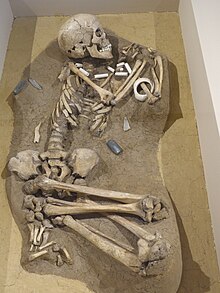
Aiterhofen is ever since the Neolithic populated, as the discovery of the largest Linear Pottery burial ground in Germany with about 260 graves in the district Ödmühle shows.
In 773 AD, Aiterhofen was first mentioned as Villa Eitraha as an Agilolfingian ducal court. About the 973 comes another mention as Eitarahoue, so courtyard at the Eiterach. A chronicler of the 11th century misinterpreted the name as court of poison (= pus). But the actual meaning is derived from the Indo-European oid for swell and the Old High German terms aha for water and courtyard for property. The place name means something like “property on the swelling watercourse”, which makes the reference to the Aiterach river.
The Romanesque parish church of St. Margaretha was probably built in the first quarter of the 13th century . It houses the oldest bell in Lower Bavaria (1325). Of the two originally planned towers, only the north tower was built. The 18th century Rococo furnishings were removed in 1883. The neighboring cemetery chapel probably dates from the 17th century.
In 1846 Angela Fraundorfer founded the monastery of the Franciscan Sisters of Aiterhofen , which today runs a kindergarten and a secondary school as well as other facilities.
Aiterhofen belonged to the rent office and regional court of Straubing of the Electorate of Bavaria. In the course of the administrative reforms in Bavaria , today's municipality was created with the municipal edict of 1818 .
Incorporations
On May 1, 1978, the previously independent municipalities of Geltolfing and Niederharthausen and most of the dissolved municipality of Amselfing (Amselfing, Ainbrach, Asham, Fruhstorf, Hermannsdorf, Hunderdorf, Moosdorf and Sand) were incorporated. Of the independent city of Straubing , the district changed Rohrhof 1978 Arch Straubing Aiterhofen to the municipality in the county.
Population development
In the period from 1988 to 2018, the municipality grew from 2,815 to 3,339 by 524 inhabitants or 18.6%.
- 1961: 2,296 inhabitants
- 1970: 2,424 inhabitants
- 1987: 2,749 inhabitants
- 1991: 2,896 inhabitants
- 1995: 3,082 inhabitants
- 2000: 3,178 inhabitants
- 2005: 3,466 inhabitants
- 2010: 3,386 inhabitants
- 2015: 3,312 inhabitants
politics
mayor
Mayor is Adalbert Hösl (CSU).
Partner communities
Aiterhofen maintains partnerships with the East Tyrolean municipality of Iselsberg-Stronach and with the Italian municipality of Montefino in Abruzzo .
Culture and sights
- St. Margareta in Aiterhofen was probably built in the first quarter of the 13th century. The interior of the Romanesque church was baroque in the 18th century and designed in the Art Nouveau style in the 19th century .
- St. Peter and Paul in Geltolfing . The current construction was started in 1715 by Jakob Ruesch . A church in Geltolfing was mentioned in a document as early as 1126.
- St. Johannes in Niederharthausen was built in the early Gothic . However, only the choir with ribbed vault remains of the original substance .
- Geltolfing Castle
- Monastery Church Aiterhofen of the monastery of St. Joseph
Architectural monuments
Economy and Infrastructure
Economy including agriculture and forestry
In 1998 there were 31 in agriculture and forestry, 133 in manufacturing and 62 in trade and transport at the place of work. In other economic areas 132 people were employed at the place of work subject to social security contributions. There were a total of 1022 employees at the place of residence subject to social security contributions. There were none in the manufacturing industry (as well as mining and quarrying of stones and earth), and there were four in the construction industry. In addition, in 1999 there were 96 farms with an agricultural area of 3517 ha. Of this, 3431 ha were arable land and 82 ha were permanent green areas.
About two kilometers from the village, in the Niederharthausen district on the SR9 district road, there is a Bayern-Ei company .
education
There are the following facilities:
- “Maria Schutz” kindergarten run by the Franciscan Sisters Aiterhofen with four groups and an attached crèche
- Herzog-Tassilo-Grundschule Aiterhofen : 107 students and six full-time teachers (as of 2018/2019)
- Angela-Fraundorfer-Realschule der Franziskanerinnen Aiterhofen : 314 students and 24 full-time teachers with a student home for girls (as of: 2018/2019)
- Vocational school for geriatric care and vocational school for geriatric care help of the Franciscan Sisters Aiterhofen: 69 pupils and seven full-time teachers (total, as of 2018/2019)
Sons and daughters of the place
- Joseph Zach (1829–1898), Catholic clergyman, member of the German Reichstag
literature
- Norbert Niszery: Linear ceramic grave fields in Bavaria (Aiterhofen-Ödmühle, Senkhofen, Mangolding and Dillingen-Steinheim). Leidorf Verlag, Espelkamp 1995.
Web links
- [www.aiterhofen.de Homepage]
- Entry on the coat of arms of Aiterhofen in the database of the House of Bavarian History
- Aiterhofen in the location database of the Bayerische Landesbibliothek Online . Bavarian State Library
Individual evidence
- ↑ "Data 2" sheet, Statistical Report A1200C 202041 Population of the municipalities, districts and administrative districts 1st quarter 2020 (population based on the 2011 census) ( help ).
- ↑ a b Local elections in the district of Straubing-Bogen. District Sraubing-Bogen, accessed on May 30, 2020 .
- ↑ CSU Aiterhofen
- ^ Aiterhofen community in the local database of the Bayerische Landesbibliothek Online . Bayerische Staatsbibliothek, accessed on July 3, 2017.
- ↑ District. Municipalities and districts. Bavarian Surveying Administration, archived from the original on April 11, 2013 ; accessed on March 31, 2015 .
- ↑ District in PDF. (PDF; 1.9 MB) Bavarian Surveying Administration, archived from the original on April 2, 2015 ; accessed on March 31, 2015 .
- ^ Federal Statistical Office (ed.): Historical municipality directory for the Federal Republic of Germany. Name, border and key number changes in municipalities, counties and administrative districts from May 27, 1970 to December 31, 1982 . W. Kohlhammer GmbH, Stuttgart / Mainz 1983, ISBN 3-17-003263-1 , p. 632 .
- ↑ Bavarian State Office for Statistics and Data Processing (Hrsg.): The municipalities of Bavaria according to the territorial status May 25, 1987. The population of the municipalities of Bavaria and the changes in the acquisitions and territory from 1840 to 1987 (= contributions to Statistics Bavaria . Issue 451). Munich 1991, p. 70 , urn : nbn: de: bvb: 12-bsb00070717-7 ( digital copy - footnote 2).
- ↑ Bavarian State Office for Statistics and Data Processing (Hrsg.): The municipalities of Bavaria according to the territorial status May 25, 1987. The population of the municipalities of Bavaria and the changes in the acquisitions and territory from 1840 to 1987 (= contributions to Statistics Bavaria . Issue 451). Munich 1991, p. 58 , urn : nbn: de: bvb: 12-bsb00070717-7 ( digitized version - footnote 3).
- ^ Kindergarten Maria Schutz Aiterhofen. (No longer available online.) Archived from the original on December 20, 2016 ; Retrieved April 30, 2015 .
- ↑ Herzog-Tassilo-Grundschule Aiterhofen in the school database of the Bavarian State Ministry for Education and Culture , accessed on August 27, 2019.
- ↑ Angela Fraundorfer Realschule der Franziskanerinnen Aiterhofen in the school database of the Bavarian State Ministry for Education and Culture , accessed on August 27, 2019.
- ^ Vocational school for geriatric care in the school database of the Bavarian State Ministry for Education and Culture , accessed on August 27, 2019.
- ↑ Vocational school for geriatric care help in the school database of the Bavarian State Ministry for Education and Culture , accessed on August 27, 2019.


