Niederwinkling
| coat of arms | Germany map | |
|---|---|---|

|
Coordinates: 48 ° 53 ' N , 12 ° 49' E |
|
| Basic data | ||
| State : | Bavaria | |
| Administrative region : | Lower Bavaria | |
| County : | Straubing arch | |
| Management Community : | Schwarzach | |
| Height : | 320 m above sea level NHN | |
| Area : | 25.65 km 2 | |
| Residents: | 2814 (Dec. 31, 2019) | |
| Population density : | 110 inhabitants per km 2 | |
| Postal code : | 94559 | |
| Area code : | 09962 | |
| License plate : | SR , BOG, MAL | |
| Community key : | 09 2 78 159 | |
| LOCODE : | DE NWK | |
| Community structure: | 34 districts | |
| Association administration address: | Marktplatz 1 94374 Schwarzach |
|
| Website : | ||
| Mayor : | Ludwig Waas ( FW ) | |
| Location of the community Niederwinkling in the district of Straubing-Bogen | ||
Niederwinkling is a municipality in the Lower Bavarian district of Straubing-Bogen and a member of the Schwarzach administrative community .
geography
Geographical location
The municipality is centrally located in the eastern Bavarian region in a terrace on the edge of the Danube valley, the so-called Niederwinklinger Randbucht. In addition, the foothills of the Bavarian Forest (the Welchenberg) are part of it. The community is thus between Gäuboden and the Bavarian Forest . The highest point of the municipality is 399 m above sea level. NN, the deepest at 313 m above sea level. NN.
Another name for parts of the municipality is "Heiwisch". The community belongs to the Danube Forest planning region .
Neighboring communities
The communities bordering Niederwinkling are Schwarzach, Offenberg, Mariaposching, Irlbach and Bogen (clockwise).
Community structure
Niederwinkling has 34 districts:
|
There are the districts Niederwinkling and Waltendorf.
history
Already in the Younger Stone Age , ie 4000–1800 BC. BC, the first rural settlements of people in the Niederwinkling area can be ascertained. Around 500 BC The Celts settled in the area and grew wine. They were followed by the Romans at the birth of Christ . After the fall of the Roman Empire around 600 AD, Bavarian clans crossed the Danube and the Bavarian Winchilo settled here. A grandson of Winchilo, the free farmer Friedrich, gave his own church and eight courtyards to the Niederalteich monastery in 741 , where it remained until 1194.
The two places Oberwinkling and Niederwinkling were administered by different families of knights in the following years, until the widow of the knight Hans von Pürching gave Niederwinkling, Oberwinkling and Welchenberg to the Oberalteich monastery in 1657 , to which it belonged until the secularization in 1803. Parish edict In the course of the administrative reforms in Bavaria, the parish Niederwinkling came into being with the second parish edict of 1818, while the parish was called Oberwinkling. Since a common church was built between 1908 and 1910 in the middle between the two districts of Ober- and Niederwinkling, the districts grew closer and closer together.
Since the 2000s, due to its convenient location on the A3 motorway and its proximity to the Deggendorf motorway junction with the A92 motorway, the community of Niederwinkling has developed from an initially agricultural community to an industrial and commercial location.
Welchenberg is an old aristocratic seat. Small remains of the former castle, an “arx perelegans in monte” (original quote from Wening), can still be found on the “Schlossberg”. Welchenberg was first mentioned in a document in 750 AD, as the Benedictine monastery Niederalteich owned vineyards here. The Welchenberg family is attested to around 1100, and their line probably died out in the 14th century. From then on there were changing owners of Hofmark Welchenberg. From 1658 the Benedictines from Oberalteich determined the history of the place, who built a priory. The last noblewoman, Katharina von Pürching, had died childless and bequeathed the Hofmark to the monastery. In the same year they built a "courtyard tavern" with a brewery on today's state road. Secularization brought worldly owners. The large and stately brewery by village standards still exists and is now home to the famous Landgasthof Buchner. The castle, however, no longer properly maintained by the priests, because it was on the mountain and therefore difficult to reach, gradually fell into disrepair. The church of St. Mauritius from the early baroque period is beautifully situated on a ledge of the Schlossberg above the Danube plain.
Incorporations
On January 1, 1971, the community of Waltendorf was incorporated. On January 1, 1978, the eastern part of the former municipality of Pfelling followed with Espern, Haag, Hagengrub, Lenzing and Welchenberg .
Population development
In the period from 1988 to 2018, the municipality grew from 1,783 to 2,771 by 988 inhabitants or 55.4%.
| date | Residents |
|---|---|
| December 01, 1840 | 1156 |
| 05/17/1939 | 1472 |
| 09/13/1950 | 1826 |
| 06/06/1961 | 1459 |
| 05/25/1987 | 1759 |
| December 31, 1991 | 1859 |
| December 31, 1995 | 1963 |
| December 31, 2000 | 2038 |
| 06/30/2005 | 2280 |
| December 31, 2010 | 2508 |
| December 31, 2015 | 2607 |
83.3 percent of the community's population are Roman Catholic, 4.9 percent Protestant and 11.8 percent belong to another or no religious community. Niederwinkling has 3.1 percent foreigners (as of May 9, 2011).
politics
mayor
In the 2014 municipal elections , the incumbent Ludwig Waas (Free Voters) prevailed as mayor with 81.77% of the votes against Thomas Kammerl (CSU). Likewise in 2020 with 83.7%.
Municipal council
The 2020 local elections on March 15 and earlier resulted in the following allocation of seats:
| Free voters | CSU | CWG-W. | FDP-FWG | total | |
| 2020 | 7th | 3 | 2 | 2 | 14th |
| 2014 | 6th | 4th | 2 | 2 | 14th |
| 2008 | 6th | 4th | 2 | 2 | 14th |
coat of arms
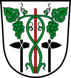
The coat of arms, which has been in use since 1967, shows two green vines on a red vine, each with a green leaf and a green grape, next to each side an upright, black stone ax.
The vine in the coat of arms is a reminder of the medieval winemaking tradition in the municipality. The stone axes from the Younger Stone Age found here in 1953/1954 point to the early settlement.
partnership
-
 There has been an official partnership with the Upper Austrian market town of Gaspoltshofen since March 22, 1977 , which was preceded by a long-standing friendship between the two communities.
Culture, sights and leisure
freetime and recreation
- outdoor pool
- gym
- 2 soccer fields
- 4 tennis courts
- Community library
- Village and meeting center
- Community center
societies
Numerous clubs are involved in the fields of sport, music and social affairs and thus enliven the life of the community.
Architectural monuments
- Parish church of St. Wolfgang and St. Johannes in Oberwinkling, built between 1908 and 1910 in neo-baroque style
- Church of St. Mauritius in Welchenberg, baroque church built around 1660 to 1670
- Filial church St. Koloman in Lenzing, around 1500
Economy and Infrastructure
Niederwinkling as a business location
The community of Niederwinkling has developed from an initially agricultural community to an industrial and commercial location. The first step towards this was the establishment of the Wallstabe & Schneider company in 1960, which has developed into a global company and employs over 700 people at its headquarters and founding headquarters in Niederwinkling.
In the industrial and commercial area of Schaidweg directly at the A3 motorway exit, the settlement of further companies began in 1991. The development of additional industrial and commercial areas led to a constant increase in the number of companies and employees. By 2015 almost 20 new industrial and commercial enterprises with over 1000 new jobs had settled there.
More workers commute to Niederwinkling than they do. The tax revenue increased from 5,929,000 euros (2008) to 11,486,000 euros (2012).
In 2003 the municipality of Niederwinkling received the Bavarian Quality Award from the Bavarian State Ministry for Economic Affairs, Infrastructure, Transport and Technology as a business-friendly municipality in 2003.
The community has not received any key allocations since 2005 and has been debt-free since the end of 2007.
The tax rate per inhabitant was 3114.84 euros in 2015. This puts Niederwinkling in 1st place in the Straubing-Bogen district, 2nd in Lower Bavaria and 11th in Bavaria.
traffic
The municipality of Niederwinkling is located on the federal motorway 3 (E56). In addition, it is crossed by the state highways St 2125 (Deggendorf – Niederwinkling – Bogen) and St 2147 (Niederwinkling – Schwarzach – Mitterfels).
The nearest train station is in the arch on the Straubing – Miltach railway line, ten kilometers away . In Straubing there is a connection to the main line Regensburg – Passau . The distance to Deggendorf Hauptbahnhof station ( Plattling – Bayerisch Eisenstein line ) is around 15 kilometers.
The nearest Danube port is in Deggendorf at a distance of 16 kilometers. There is also a free trade port in Deggendorf. The distance to the nearest well-developed airfield, Straubing Airfield , is 30 kilometers.
education
In Niederwinkling there is a community library, a kindergarten with 114 children, a day nursery with 17 places and a primary school with 152 pupils with possible afternoon care (as of 2013).
Awards
- Business-friendly community 2003; Bavarian Quality Award from the Bavarian State Ministry for Economic Affairs, Infrastructure, Transport and Technology
- Municipality of the year 2010; Grand Prize for Medium-Sized Enterprises from the Oskar Patzelt Foundation
- Premier Commune 2013; Grand Prize for Medium-Sized Enterprises from the Oskar Patzelt Foundation
Personalities
- Heinrich Kilger the Elder (1881–1965), brewer, social democratic city councilor in Heidelberg, born in Niederwinkling
- Hans Körnig , painter and graphic artist (1905–1989), lived in Niederwinkling for a few years.
- Hans-Jürgen Buchner (* 1944), musician, composer of film music and head of the Lower Bavarian group Haindling, spent his youth in Welchenberg
- Bettina Tremmel (* 1971), Roman Provincial Archaeologist, grew up in Niederwinkling
Individual evidence
- ↑ "Data 2" sheet, Statistical Report A1200C 202041 Population of the municipalities, districts and administrative districts 1st quarter 2020 (population based on the 2011 census) ( help ).
- ↑ Niederwinkling community in the local database of the Bavarian State Library Online . Bavarian State Library, accessed on October 29, 2017.
- ↑ District. Municipalities and districts. Bavarian Surveying Administration, archived from the original on April 11, 2013 ; accessed on March 31, 2015 .
- ^ Wilhelm Volkert (ed.): Handbook of Bavarian offices, communities and courts 1799–1980 . CH Beck, Munich 1983, ISBN 3-406-09669-7 , p. 437 .
- ^ Federal Statistical Office (ed.): Historical municipality directory for the Federal Republic of Germany. Name, border and key number changes in municipalities, counties and administrative districts from May 27, 1970 to December 31, 1982 . W. Kohlhammer GmbH, Stuttgart and Mainz 1983, ISBN 3-17-003263-1 , p. 632 .
- ↑ Local elections in the district of Straubing-Bogen. District Sraubing-Bogen, accessed on May 30, 2020 .
- ^ Members of the parish council. In: Niederwinkling.de. May 1, 2020, accessed June 2, 2020 .
Web links
- Entry on Niederwinkling's coat of arms in the database of the House of Bavarian History
- Niederwinkling: Official statistics of the LfStat
- Niederwinkling website
- Niederwinkling at regiowiki


