
Mitterfels
| coat of arms | Germany map | |
|---|---|---|

|
Coordinates: 48 ° 59 ' N , 12 ° 41' E |
|
| Basic data | ||
| State : | Bavaria | |
| Administrative region : | Lower Bavaria | |
| County : | Straubing arch | |
| Management Community : | Mitterfels | |
| Height : | 407 m above sea level NHN | |
| Area : | 14.23 km 2 | |
| Residents: | 2823 (Dec. 31, 2019) | |
| Population density : | 198 inhabitants per km 2 | |
| Postal code : | 94360 | |
| Area code : | 09961 | |
| License plate : | SR , BOG, MAL | |
| Community key : | 09 2 78 151 | |
| Market structure: | 36 districts | |
Market administration address : |
Burgstrasse 1 94360 Mitterfels |
|
| Website : | ||
| Mayor : | Andreas Liebl ( Free Association of Voters ) | |
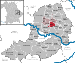
| Location of the Mitterfels market in the Straubing-Bogen district | ||
  |
||

Mitterfels is a market in the Lower Bavarian district of Straubing-Bogen and the seat of the Mitterfels administrative community . Mitterfels is a state-approved climatic health resort .
geography
location
The market is located in the Bavarian Forest Nature Park on a rock plateau above the Menach . The exposed location earned the place the name “Bavarian Jerusalem” early on.
The highest point in the municipality is 496 m above sea level. NHN in the Kögl district , the deepest at 324 m above sea level. NHN in the district of Aichmühl .
Community structure
The municipality of Mitterfels has 36 parts of the municipality:
There is only the district Mitterfels.
Some of the former districts are Hochfeld , Leimgruben, Reinbach , Reitschul, Unterholzen , Weiherfeld , Ziegelhütte .
Neighboring communities
climate
Mitterfels is a state-approved climatic health resort . The annual mean temperature is 7 ° C – 8 ° C, the total annual precipitation is between 750 mm and 850 mm.
history
Until the church is planted
In 1104 the Counts von Bogen founded the nearby Oberalteich monastery . The Castle Mitterfels first mentioned 1194th This fell to the Wittelsbach family when the Counts of Bogen died out in 1242 . Mitterfels was the seat of a nursing office from 1280 to 1799 and a regional court of the Electorate and Kingdom of Bavaria from 1799 to 1879 . During the Thirty Years War , Mitterfels fortress fell to the Swedes in 1633/34. In the 18th century, attacks by the Pandours were successfully repulsed. In the course of the administrative reforms in Bavaria , today's municipality was created with the municipal edict of 1818 . It was formed from the locations of the Mitterfels tax district and individual locations from the Gaishausen (Vorder- and Hinterbuchberg), Haselbach (Einfürst) and Ascha (Auhof, Englberg, Hörmannsberg) tax districts.
19th to 21st century
The district court was dissolved in 1861, a district court existed in Schloss Mitterfels until 1973. Despite its central function as the administrative center, Mitterfels had no market or town rights . It was only raised to the market in 1968 . The castle complex, which is now owned by the municipality and the seat of the Mitterfels administrative community, is one of the region's most significant architectural monuments. The historical Hien-Sölde , a small farmhouse built in 1436 in log construction , is of national importance.
Incorporations
In 1876 the community Scheibelsgrub was incorporated. On May 1, 1978, the districts of Hagnberg, Kögl and Wiespoint of the dissolved community Gaishausen were incorporated into Mitterfels.
Population development
| year | 1840 | 1871 | 1900 | 1925 | 1939 | 1950 | 1961 | 1970 | 1987 | 1991 | 1995 | 2000 | 2005 | 2006 | 2007 | 2008 | 2009 | 2010 | 2011 | 2012 | 2013 | 2014 | 2015 | 2016 | 2017 | 2018 |
|---|---|---|---|---|---|---|---|---|---|---|---|---|---|---|---|---|---|---|---|---|---|---|---|---|---|---|
| Residents | 949 | 1017 | 1047 | 1098 | 1136 | 1630 | 1583 | 1659 | 2047 | 2125 | 2221 | 2372 | 2459 | 2504 | 2478 | 2483 | 2468 | 2445 | 2421 | 2441 | 2467 | 2514 | 2609 | 2732 | 2799 | 2807 |

politics
The first mayor is Andreas Liebl (FWG), he received 66.78% of the valid votes in the 2020 mayoral election. His predecessor was Heinrich Stenzel ( Free Voting Association ), who succeeded Werner Lang ( CSU / Independent Citizens) in 2002 . The municipal council consists of the first mayor and 14 council members. After the 2020 local elections , the 14 seats will be distributed among the nominations as follows:
| List / party | Seats |
| Free Association of Voters (FWG) | 5 |
| Christian Social Union in Bavaria (CSU) / Independent Citizens | 4th |
| Social Democratic Party of Germany (SPD) / Free Citizens | 2 |
| Christian voters Mitterfels | 2 |
| Green | 1 |
Culture and sights
- Mitterfels Castle emerged from the castle complex of the Counts of Bogen. The remains of the medieval castle complex are separated from the village by a 20 meter deep moat , which is spanned by a stone bridge built in 1791. The main tower collapsed in 1812. Remains of the curtain wall, the prison wing from the 18th century and the nursing home have been preserved. The castle, which was built in 1780 instead of an older building, was formerly a maintenance , regional and district court, has served as the town hall since 1973 and has been the seat of the Mitterfels administrative association since 1977.
- The former prison was added to the tower kennel in the 18th century. It was a prison of the district court until 1879 and the district court of Mitterfels until 1949 . The local history museum with original prison cells has been located here since 1982.
- The side church of St. George was built from a castle and palace chapel . It was rebuilt in 1734 and was a branch church of the Kreuzkirchen monastery parish until 1805 . From 1805 to 1970 it served as the parish church of the new Mitterfels parish until it was replaced by the new Hl. Geist building. The two-bay nave has a Tuscan pilaster structure and a lancet vault .
- Since 2001, Singspiele and musicals have been performed in the Burggarten by the Burgtheaterverein Mitterfels.
Soil monuments
See: List of ground monuments in Mitterfels
Economy and Infrastructure
Economy including agriculture and forestry
In 1998, according to official statistics, there were 35 employees in the field of agriculture and forestry, 126 in the manufacturing industry and 111 in the field of trade and transport. In other economic sectors this figure was 194 people. There were 699 employees at the place of residence subject to social insurance contributions. There were eight companies in the manufacturing sector and four in the construction sector. In addition, in 1999 there were 46 farms with an agricultural area of 728 ha, of which 355 ha were arable land and 371 ha were permanent green space.
traffic
The state road in 2140 and the state road 2147 intersect in Mitterfels. The distance to the A3 motorway is six kilometers. The federal highway 20 can be reached in five kilometers. By the railway Straubing-Miltach the place was tied in the period 1896-1984 to the railway network.
education
There is a day care center, two general schools and two public vocational schools.
In 2015, a total of 79 children were cared for in the day-care center with 92 approved places (75 kindergarten, 17 crèche). In the Mitterfels-Haselbach elementary and middle school , a total of 335 students were taught by 25 teachers in 2018/2019, of which 154 were taught by eight teachers in the elementary school. At the Staatl. In 2018/2019, seven teachers taught 56 students at the Mitterfels vocational school for nutrition and supply . Vocational school for child care in Mitterfels , 83 students were trained by seven full-time teachers. The district music school of the Straubing-Bogen district is based in Mitterfels.
Personalities
Connected to Mitterfels
- Johann Kaspar Thürriegel (1722–1800), adventurer, clerk in Mitterfels
- Hans Gutbrod (1877–1948), veterinarian
- Gustav Kelber (1881–1961), Bavarian writer and lawyer
- Johann Wartner (1883–1963), Member of Parliament, from the Scheibelsgrub district
- Georg Fritz (1884–1967), painter and graphic artist
- Hans Rieser (* 1934), Austrian sculptor
- Wolfgang Hammer (* 1946), educator and author
- Alexander Stern (* 1976), sculptor, painter and installation artist
- Johanna Uekermann (* 1987), politician (SPD)
Born in Mitterfels
- Johann Strassmaier (1846–1920), ancient orientalist
- Wilhelm Bohl (1886–1958), theologian
- Franz Mayer (1920–1977), legal scholar, first rector of the University of Regensburg
- Adelheid Brunner (* 1957), judoka
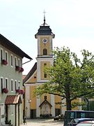
The former parish church of St. Georg
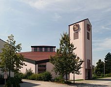
The new parish church of the Holy Spirit
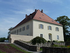
The town hall of Mitterfels

The former prison

Historic Hien-Sölde , built in 1436


literature
- Markt Mitterfels, A selection of important statistical data . In: Bavarian State Office for Statistics (ed.): Statistics communal 2018 . March 2019 ( online [PDF]).
Web links
- Mitterfels market
- Mitterfels: Official statistics of the LfStat
- Entry on the Mitterfels coat of arms in the database of the House of Bavarian History
- Online magazine designed by citizens (mitterfels-online.de)
- Work group Heimatgeschichte Mitterfels eV (ak-heimatgeschichte.mitterfels-online.de)
Individual evidence
- ↑ "Data 2" sheet, Statistical Report A1200C 202041 Population of the municipalities, districts and administrative districts 1st quarter 2020 (population based on the 2011 census) ( help ).
- ↑ Markt Mitterfels in the local database of the Bayerische Landesbibliothek Online . Bavarian State Library, accessed on July 13, 2017.
- ↑ District. Municipalities and districts. Bavarian Surveying Administration, archived from the original on April 11, 2013 ; accessed on March 31, 2015 .
- ↑ a b c Kgl. Statistical Bureau (ed.): Complete list of localities of the Kingdom of Bavaria. According to districts, administrative districts, court districts and municipalities, including parish, school and post office affiliation ... with an alphabetical general register containing the population according to the results of the census of December 1, 1875 . Adolf Ackermann, Munich 1877, 2nd section (population figures from 1871, cattle figures from 1873), Sp. 402 , urn : nbn: de: bvb: 12-bsb00052489-4 ( digitized version ).
- ↑ a b Josepf Lipf (Editor): matrikel bishopric of Regensburg . Ed .: Diocese of Regensburg. Pustet, Regensburg 1838, p. 232-233 ( digitized version ).
- ^ Bavarian State Office for the Environment, GeoFachdatenAtlas
- ^ Wilhelm Volkert (ed.): Handbook of Bavarian offices, communities and courts 1799–1980 . CH Beck, Munich 1983, ISBN 3-406-09669-7 , p. 437 .
- ^ Federal Statistical Office (ed.): Historical municipality directory for the Federal Republic of Germany. Name, border and key number changes in municipalities, counties and administrative districts from May 27, 1970 to December 31, 1982 . W. Kohlhammer GmbH, Stuttgart / Mainz 1983, ISBN 3-17-003263-1 , p. 633 .
- ^ Bavarian State Office for Statistics and Data Processing - Local Elections
- ↑ Kindergarten of the parish Mitterfels. Parish community Mitterfels-Haselbach, accessed on April 19, 2014 .
- ↑ Mitterfels-Haselbach primary school in the school database of the Bavarian State Ministry for Education and Culture , accessed on July 23, 2019.
- ↑ Middle School Mitterfels-Haselbach in the school database of the Bavarian State Ministry for Education and Culture , accessed on July 23, 2019.
- ↑ State. Vocational school for nutrition and supply Mitterfels in the school database of the Bavarian State Ministry for Education and Culture , accessed on September 24, 2019.
- ↑ State. Vocational school for child care Mitterfels in the school database of the Bavarian State Ministry for Education and Culture , accessed on September 24, 2019.

Aholfing | Aiterhofen | Ascha | Atting | Bow | Falkenfels | Feldkirchen | Geiselhöring | Haibach | Haselbach | Hunderdorf | Irlbach | Kirchroth | Konzell | Laberweinting | Leiblfing | Loitzendorf | Mallersdorf-Pfaffenberg | Mariaposching | Mitterfels | Neukirchen | Niederwinkling | Oberschneiding | Parkstetten | Perasdorf | Perkam | Rain | Rattenberg | Rattiszell | Salching | Sankt Englmar | Schwarzach | Stallwang | Steinach | Straßkirchen | Wiesenfelden | Windberg
Aichmühl | Aign | Auhof | Dunk | Einfürst | Eisenhart | Englberg | Großkohlham | Hagnberg | Herrnberg | Hinterbuchberg | Courtier | Höllmühl | Hörmannsberg | Box field | Kleinkohlham | Kögl | Kreuzkirchen | Rental | Mitterfels | Neumühle | Oberhartberg | Pürstenberg | Scheibelsgrub | Schoppühl | Spur Huttling | Stone house | Steinrießl | Straßhof | Valley mill | Unterhartberg | Vorderbuchberg | Vineyard | Wiespoint | Wollersdorf | Zackenberg