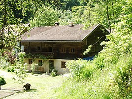
Talmühle (Mitterfels)
|
Valley mill
Mitterfels market
Coordinates: 48 ° 58 ′ 11 " N , 12 ° 40 ′ 56" E
|
|
|---|---|
| Height : | 345 m above sea level NN |
| Residents : | 7 (May 25 1987) |
| Postal code : | 94360 |
| Area code : | 09961 |
|
Listed house in Talmühle
|
|
Talmühle is a hamlet and part of the Mitterfels market in the Straubing-Bogen district in Lower Bavaria .
location
Talmühle is located on the Menach and to the north below Mitterfels Castle on the so-called Teufelsfelsen .
history
In the land register of the Mitterfels caste office from 1555, the mill in the valley is listed and also called a bath house near the mill. In 1829 a mill with a single grinder is mentioned. Nevertheless, Talmühle was not yet listed as a district for the Mitterfels tax district in 1811 and was only listed in the censuses from 1950.
Population development

| year | 1838 | 1860 | 1916 | 1950 | 1961 | 1970 | 1987 |
|---|---|---|---|---|---|---|---|
| Residents | 11 | 14th | 5 | 24 | 20th | 13 | 7th |
Name spelling
The spelling Thalmühl was also used earlier .
Culture and sights
Architectural monuments
→ Main article: List of architectural monuments in Mitterfels
literature
- Wartner, Franz: The valley mill. In: Mitterfelser Magazin. No. 4. Working group Heimatgeschichte Mitterfels eV, 1998, pp. 23-25 , archived from the original on May 4, 2014 ; Retrieved May 4, 2014 .
Nature and landscape protection
Talmühle is located in the Bavarian Forest conservation area .
Web links
- Talmühle in the local database of the Bavarian State Library Online . Bavarian State Library
Individual evidence
- ↑ a b Bavarian State Office for Statistics and Data Processing (Ed.): Official local directory for Bavaria, territorial status: May 25, 1987 . Issue 450 of the articles on Bavaria's statistics. Munich November 1991, DNB 94240937X , p. 237 ( digitized version ).
- ↑ Bayerisches Staatsarchiv Landshut, Rep. 97b, Catalog 1, Fasz. 18, No. 225
- ^ Repertory of the topographical atlas sheet .... [49], Mitterfels . Munich 1829, p. 64 , urn : nbn: de: bvb: 12-bsb10944957-0 ( digitized version - "Thalmühle, E. bey Mitterfels, 1 H. 1 Mühle (1 grinding) on the Menach stream").
- ↑ a b Josepf Lipf (Editor): matrikel bishopric of Regensburg . Ed .: Diocese of Regensburg. Pustet, Regensburg 1838, p. 232 ( digitized version ).
- ^ Diocese of Regensburg (ed.): Matriculation of the Diocese of Regensburg : according to the general parish and church description from 1860 ... Regensburg 1863, p. 315 ( digitized version ).
- ^ Diocese of Regensburg (ed.): Register of the Diocese of Regensburg . ed. i. A. Sr Excellency of the Most Revered Bishop Dr. Antonius von Henle from the Episcopal Ordinariate Regensburg. Regensburg 1916, p. 135 ( digitized version ).
- ↑ Bavarian State Statistical Office (ed.): Official place directory for Bavaria - edited on the basis of the census of September 13, 1950 . Issue 169 of the articles on Bavaria's statistics. Munich 1952, DNB 453660975 , Section II, Sp. 374 ( digitized version ).
- ↑ Bavarian State Statistical Office (ed.): Official city directory for Bavaria, territorial status on October 1, 1964 with statistical information from the 1961 census . Issue 260 of the articles on Bavaria's statistics. Munich 1964, DNB 453660959 , Section II, Sp. 278 ( digitized version ).
- ^ Bavarian State Statistical Office (ed.): Official place directory for Bavaria . Issue 335 of the articles on Bavaria's statistics. Munich 1973, DNB 740801384 , p. 114 ( digitized version ).
- ↑ Bavaria Atlas of the Bavarian State Government ( notes )

