
Menach
|
Menach Mehnach Perlbach (section in Mitterfels) Altaich (historical) |
||
 Menach near Haselbach |
||
| Data | ||
| Water code | EN : 1586 | |
| location | District of Straubing-Bogen | |
| River system | Danube | |
| Drain over | Kinsach → Danube → Black Sea | |
| origin | at Menhaupten in Konzell 49 ° 4 ′ 41 ″ N , 12 ° 43 ′ 29 ″ E |
|
| Source height | about 510 m | |
| muzzle | in the Kinsach in Furth , city of Bogen Coordinates: 48 ° 55 ′ 21 ″ N , 12 ° 39 ′ 50 ″ E 48 ° 55 ′ 21 ″ N , 12 ° 39 ′ 50 ″ E |
|
| Mouth height | 315 m | |
| Height difference | about 195 m | |
| Bottom slope | about 7.5 ‰ | |
| length | 26.1 km | |
| Catchment area | 57.93 km² | |
| Left tributaries | Hitzenberger Bach , Leitener Graben, Laubbergbach , Schreinerbach , Aubach , Bonholzbach , Eigraben , Dannergraben , Weiherbach | |
| Right tributaries | Irlberger Graben, Großer Wiedener Graben , Aigner Graben, Irschenbach , Roßhauptener Graben , Bergbach , Reinbach , Kreuzkirchner Bach , Weiherhofgraben, Birnbach | |
| Small towns | arc | |
| Communities | Konzell , Haibach , Haselbach , Mitterfels | |
The Menach (also written Mehnach , formerly also Mennach) is a brook in the Straubing-Bogen district , Lower Bavaria . It is one of the northern tributaries of the Danube in the Bavarian Forest .
course
It rises near Konzell and flows through the communities of Haibach , Haselbach and Mitterfels towards Bogen .

Sections
The height profile of the Menach can be roughly divided into four sections. In the first section of about seven kilometers from the source to Recksberg , there is a clear gradient and accordingly little meander formation. This is followed by an approximately ten-kilometer section with a slight gradient and sometimes pronounced meandering. In the Mitterfels area, there is a change to a short, steep section with the appearance of a torrent . When the foothills of the Danube Plain are reached, a calm section begins again in the unregulated sections with sometimes very pronounced loops in the course. The last kilometers up to the confluence with the Kinsach-Menach-Ableiter are marked by strong interventions by the flood protection structures.
Branch in Furth
|
Menach (branch) Mehnach |
||
 Branching of the Menach in Furth |
||
| Data | ||
| Water code | DE : 15872 | |
| location | District of Straubing-Bogen | |
| River system | Danube | |
| Drain over | Kinsach → Danube → Black Sea | |
| branch | at Furth (Bogen) 48 ° 55 ′ 29 ″ N , 12 ° 39 ′ 57 ″ E |
|
| Source height | about 318 m | |
| muzzle | in the Kinsach in arc 48 ° 54 ′ 22 ″ N , 12 ° 41 ′ 15 ″ E |
|
| Mouth height | 313 m | |
| Height difference | about 5 m | |
| Bottom slope | about 1.6 ‰ | |
| length | 3.1 km | |
| Catchment area | 2.6 km² | |
| Small towns | arc | |
In Furth (city of Bogen) the Menach branches out. The main stream on the right branch passes a rough ramp and flows into the Kinsach after less than 300 meters . The left arm, called the Menach branch, covers another 3.31 kilometers to the mouth. It first goes through a sluice and runs almost without a gradient along the residential development in Furth, crosses under several streets between Furth and the neighboring town to come to light again in Oberalteich. The short superficial course in Oberalteich soon changes back to the underground crossing of the square in front of the monastery church. In the south of Oberalteich the Menach branch comes to the surface again and changes its direction to the east. Here the Menach still runs to the left and north of the Kinsach in order to cross the diked Kinsach after about 600 meters in a culvert . The Menach leaves this diked area between the southern dike of the Kinsach and the northern dike of the Danube at the Bogen-Land pumping station , which only transports its water over the dyke with pumping power in a flood situation. After another 600 meters, this branch of the Menach flows into the Kinsach, coming from the right and 190 meters before its own mouth.
Tributaries
The longest tributary is the Irschenbach , with a length of 2.93 km. With its catchment area of 4.77 km 2, it is in second place . With 5.17 km 2, the Eigraben is the tributary with the largest catchment area and thus has a share of 8.92% of the total catchment area of 57.93 km 2 . At the mouth of the Eigraben, the Menach has covered a distance of 10.53 km (40.4%) from its source and already covers 66% of the catchment area with 38.21 km 2 .
Diagram of the major tributaries of the Menach

Localities
- on the run from the source to the mouth. Only the entries with the greatest nesting depth are bordering waters.
- Konzell parish
- Menhaupten (wasteland, right, neighboring spring)
- Wooden house (hamlet, right)
- Hadermühl (hamlet)
- Viertl (wasteland, right slope)
- Kleinmenach (wasteland, left)
- Waldmenach (wasteland, right)
- community Haibach
- Pirkmühl (wasteland, left)
- Obermühl (wasteland, left)
- Recksberg (village, right slope)
- Krottenholz (hamlet, right)
- Bachwies (wasteland, left)
- municipality Haselbach
- Mitterfels market
- City arch
- Stegmühl (wasteland, left)
- Obermenach (wasteland, right slope)
- Häuselberg (wasteland, left, exposed on a hilltop)
- Weidenhofen (wasteland, right)
- Niedermenach (village, mostly on the right)
- Furth (village, mostly on the left, bordering the estuary) , here is a branch of the Menach and the mouth of a branch
- Oberalteich (parish village, heavily piped here)
- Bogen (city, left, bordering on the estuary)
history
Perlbach
The valley of the Mehnach in the Mitterfels area is still called the Perlbachtal there today. In this area of the Menach, as in many other streams in the area, there were significant occurrences of the pearl mussel .
Changes in the course of the Menach over time
Old maps show a branch of the Menach near Furth. The historical location of the junction was less than a hundred meters south of the current location.
The right branch
Near the junction in Furth, the right branch of the Menach flows into the Kinsach, as the Kinsach-Menach arrester is officially called today. Until the creation of this artificial river course of the Kinsach there was no body of water north parallel to the Danube, the right branch of the Menach flowed into a former backwater of the Danube, called Boigen , and then into the Danube. This backwater and the connecting waters have largely fallen dry today due to the effects of the flood protection structures. The location of the earlier mouth was about 600 meters in a south-south-west direction from today's mouth.
The left branch
The current course of the left branch, the so-called Menach branch today , corresponds almost completely to the earlier course. The piped crossing under the square in front of the Oberalteich monastery can also be deduced from the first recording from 1808–1864. Changes in this branch are essentially new structures. These are the underpasses between Furth and Oberalteich, the crossing beneath the artificial Kinakh-Menach arrester by a culvert ( 48.9137 ° N , 12.6753 ° O ) and overcoming the Danube dam at Schöpfwerk arc-Land ( 48.90758 ° N , 12.67943 ° O ) .
environment
The Mehnach is assigned to the water type of coarse material rich, silicate low mountain range brooks.
flora
In the section north of Talmühle there is a significant population of the protected ostrich fern .
Land consolidation and renaturation
In the 1960s, the Menach was straightened over a length of about one kilometer through land consolidation from the Haibach sewage treatment plant to the municipal boundary near Bachwies . However, this had a negative effect on their flow behavior and thus on vegetation and wildlife. In the summer of 2000, as part of a renaturation measure , a more natural course of the stream with meander loops , stones and tree stumps was created to create a more chaotic flow and to slow the flow speed.
Oil spill
On the evening of April 11, 2001, between Haibach and Waldmenach, a tank truck fully loaded with 32,000 liters of heating oil fell down an embankment about three meters deep. Here, probably 15,000 liters ran into the Menach, of which a large part thanks to the local volunteer fire department , who were quick with 15 emergency vehicles on site, using oil booms could be collected and pumped out. Damage to nature was limited despite this large amount, but the smell of heating oil persisted throughout the Menach Valley for days.
Receiving waters
The two municipal sewage treatment plants in Haibach and Mitterfels use the Menach as receiving waters . The expansion sizes (number of inhabitants) of the systems are 1500 in Haibach and 4750 in Mitterfels.
Water maintenance
The Menach is a third order of water along its entire length.
Discharge values
The flood discharge values near the mouth ( 48.92314 ° N , 12.66445 ° O ) are (each year to be expected) floods a statistically 1-annual HQ 1 at 12 m³ / s, for HQ 10 at 28 m / s, and a " flood of the century " HQ 100 at 45 m³ / s.
Use of hydropower
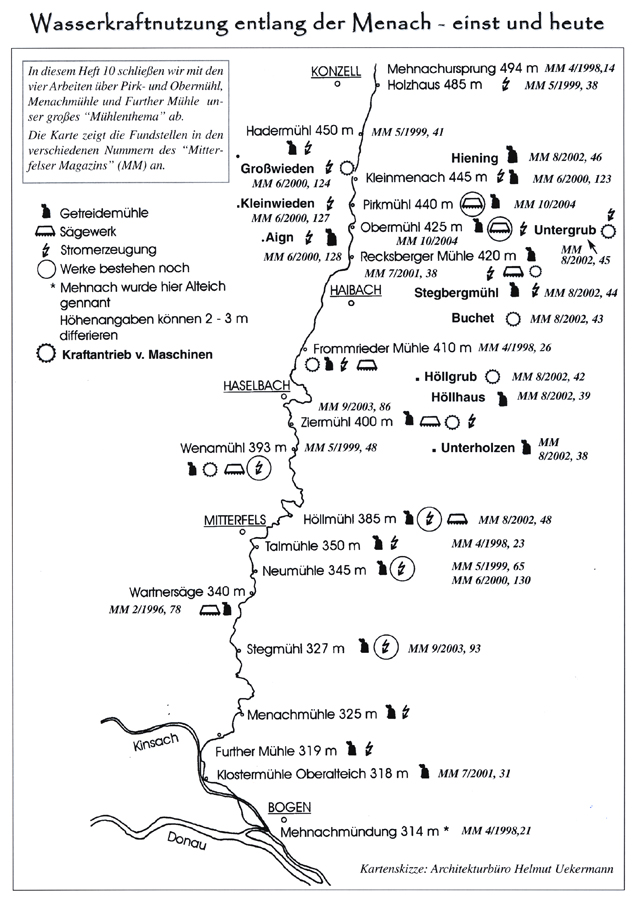
At five locations, hydropower is converted into electrical energy in small systems. These are the following locations of earlier mills: Obermühl , Wenamühl , Höllmühl , Neumühle and Stegmühl .
Web links
- Water body profile - Kinsach and others. Bavarian State Office for the Environment, accessed on April 29, 2014 .
- Profile map of the river water body - Kinsach and others. (PDF; 883 kB) Bavarian State Office for the Environment, April 2010, accessed on April 29, 2014 .
- Architects' office Helmut Uekermann: Use of hydropower along the Menach - then and now. (jpg; 286 kB) Sketch of the course of the Menach with mill locations. In: Mitterfelser Magazin No. 10. Retrieved on May 4, 2014 .
Individual evidence
- ↑ a b c Bavaria Atlas of the Bavarian State Government ( notes )
- ↑ a b c d e Directory of brook and river areas in Bavaria - Danube river area from Naab to Isar. (PDF; 2.7 MB) Bavarian State Office for the Environment, accessed on April 20, 2014 .
- ↑ Theodor von Hessling: The pearl mussels and their pearls. 1859, accessed April 29, 2014 .
- ↑ Basic map: first recording (1808–1864). In: BayernAtlas. © 2014 Bayerische Vermessungsverwaltung, accessed on May 2, 2014 .
- ↑ BASG Bavarian Forest - Excursion reports 2010 ISSN 0724-2131 .
- ↑ Map service water management Bavaria. Bavarian State Office for the Environment, accessed on May 3, 2014 : “Sewage treatment plant: Mitterfels; Development size (number of inhabitants): 4750 and sewage treatment plant: Haibach; Expansion size (number of inhabitants): 1500 "
- ↑ Planning approval, federal waterway Danube, expansion of the waterway and improvement of flood protection Straubing - Vilshofen, section 1: Straubing - Deggendorf. (PDF; 1.7 MB) Explanatory report Appendix 2. (No longer available online.) RMD Wasserstraßen GmbH, p. 58 , archived from the original on September 10, 2014 ; Retrieved February 25, 2015 . Info: The archive link was inserted automatically and has not yet been checked. Please check the original and archive link according to the instructions and then remove this notice.
- ↑ Energy Atlas Bavaria (as of 2014)