
Loitzendorf
| coat of arms | Germany map | |
|---|---|---|

|
Coordinates: 49 ° 5 ' N , 12 ° 39' E |
|
| Basic data | ||
| State : | Bavaria | |
| Administrative region : | Lower Bavaria | |
| County : | Straubing arch | |
| Management Community : | Stallwang | |
| Height : | 411 m above sea level NHN | |
| Area : | 12.03 km 2 | |
| Residents: | 606 (Dec. 31, 2019) | |
| Population density : | 50 inhabitants per km 2 | |
| Postal code : | 94359 | |
| Area code : | 09964 | |
| License plate : | SR , BOG, MAL | |
| Community key : | 09 2 78 147 | |
| Community structure: | 22 districts | |
| Association administration address: | Straubinger Str. 18 94375 Stallwang |
|
| Website : | ||
| Mayor : | Johann Anderl ( CSU ) | |
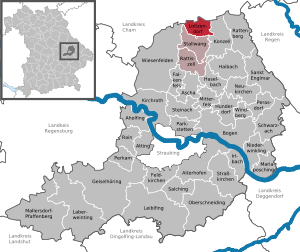
| Location of the municipality of Loitzendorf in the Straubing-Bogen district | ||
  |
||

Loitzendorf is a municipality in the Lower Bavarian district of Straubing-Bogen and a member of the Stallwang administrative community .
geography
Loitzendorf is located in the Danube Forest region in the front Bavarian Forest . The municipality belongs to the administrative community Stallwang , which has its administrative seat in the municipality of Stallwang .
Community structure
Loitzendorf has 22 districts:
|
There are the districts of Gittensdorf and Loitzendorf.
history
Until the church is planted
Loitzendorf belonged to the Straubing Rent Office of the Electorate of Bavaria . In the course of the administrative reforms in Bavaria , today's municipality was created with the municipal edict of 1818 .
Incorporations
On January 1, 1974, the previously independent community of Gittensdorf was incorporated.
Outsourcing
On May 1, 1978, the districts Haselhof , Traumarch , Weigelsberg and Wiedenhof , which were incorporated in 1974 from the former community of Gittensdorf, were reclassified into the community of Traitsching in the Cham district in Upper Palatinate .
Population development
In the period from 1988 to 2018, the municipality grew from 589 to 613 by 24 inhabitants or 4.1%.
- 1840: 626 inhabitants
- 1871: 705 inhabitants
- 1900: 702 inhabitants
- 1925: 677 inhabitants
- 1939: 597 inhabitants
- 1950: 757 inhabitants
- 1961: 572 inhabitants
- 1970: 576 inhabitants
- 1987: 581 inhabitants
- 1991: 606 inhabitants
- 1995: 611 inhabitants
- 2000: 602 inhabitants
- 2005: 630 inhabitants
- 2010: 620 inhabitants
- 2015: 614 inhabitants
politics
mayor
Johann Anderl has been the first mayor since May 2008. He was confirmed in the 2020 election with 80.29% by 2026.

Municipal council
The council consists of the first mayor and eight council members.
Community partnerships
-
 Hennersdorf in Saxony
Architectural monuments
Economy including agriculture and forestry
In 1998, according to official statistics, there were no employees in the manufacturing sector and no employees in the trade and transport sector at the place of work. There were a total of 207 employees at the place of residence subject to social security contributions. There were no companies in the manufacturing or construction industry. In 1999 there were 38 farms with an agriculturally used area of 632 hectares, of which 268 hectares were arable land and 345 hectares were permanent green areas.
Personalities
- Carl Haidn (1903–1998), politician
Individual evidence
- ↑ "Data 2" sheet, Statistical Report A1200C 202041 Population of the municipalities, districts and administrative districts 1st quarter 2020 (population based on the 2011 census) ( help ).
- ↑ a b Local elections in the district of Straubing-Bogen. District Sraubing-Bogen, accessed on May 30, 2020 .
- ^ Loitzendorf community in the local database of the Bavarian State Library Online . Bavarian State Library, accessed on September 25, 2017.
- ↑ District. Municipalities and districts. Bavarian Surveying Administration, archived from the original on April 11, 2013 ; accessed on March 31, 2015 .
- ^ Federal Statistical Office (ed.): Historical municipality directory for the Federal Republic of Germany. Name, border and key number changes in municipalities, counties and administrative districts from May 27, 1970 to December 31, 1982 . W. Kohlhammer GmbH, Stuttgart / Mainz 1983, ISBN 3-17-003263-1 , p. 631 .
- ↑ Bavarian State Office for Statistics and Data Processing (Hrsg.): The municipalities of Bavaria according to the territorial status May 25, 1987. The population of the municipalities of Bavaria and the changes in the acquisitions and territory from 1840 to 1987 (= contributions to Statistics Bavaria . Issue 451). Munich 1991, p. 71 , urn : nbn: de: bvb: 12-bsb00070717-7 ( digital copy - note 17).
- ↑ a b c d e f g h i Bavarian State Office for Statistics and Data Processing (Hrsg.): The municipalities of Bavaria according to the territorial status May 25, 1987. The population of the municipalities of Bavaria and the changes in the property and territory from 1840 to 1987 (= Contributions to Statistics Bavaria . Issue 451). Munich 1991, p. 70 , urn : nbn: de: bvb: 12-bsb00070717-7 ( digitized version ).
- ↑ Municipal Council 2014 - 2020. Municipality of Loitzendorf, accessed on September 24, 2019 .
Web links
- homepage of the community Loitzendorf
- Entry on the coat of arms of Loitzendorf in the database of the House of Bavarian History

Aholfing | Aiterhofen | Ascha | Atting | Bow | Falkenfels | Feldkirchen | Geiselhöring | Haibach | Haselbach | Hunderdorf | Irlbach | Kirchroth | Konzell | Laberweinting | Leiblfing | Loitzendorf | Mallersdorf-Pfaffenberg | Mariaposching | Mitterfels | Neukirchen | Niederwinkling | Oberschneiding | Parkstetten | Perasdorf | Perkam | Rain | Rattenberg | Rattiszell | Salching | Sankt Englmar | Schwarzach | Stallwang | Steinach | Straßkirchen | Wiesenfelden | Windberg