
Wiesenfelden
| coat of arms | Germany map | |
|---|---|---|

|
Coordinates: 49 ° 2 ' N , 12 ° 32' E |
|
| Basic data | ||
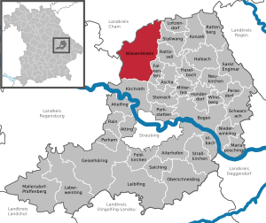
| State : | Bavaria | |
| Administrative region : | Lower Bavaria | |
| County : | Straubing arch | |
| Height : | 610 m above sea level NHN | |
| Area : | 78.19 km 2 | |
| Residents: | 3755 (Dec. 31, 2019) | |
| Population density : | 48 inhabitants per km 2 | |
| Postal code : | 94344 | |
| Area code : | 09966 | |
| License plate : | SR , BOG, MAL | |
| Community key : | 09 2 78 197 | |
| Community structure: | 87 districts | |
| Address of the municipal administration: |
Schulstr. 3 94344 Wiesenfelden |
|
| Website : | ||
| Mayor : | Andreas Urban ( FW ) | |
| Location of the municipality of Wiesenfelden in the Straubing-Bogen district | ||
  |
||


Wiesenfelden is a municipality in the Lower Bavarian district of Straubing-Bogen . It is one of the largest municipalities in the district and is located in the Falkensteiner Vorwald .
geography
Wiesenfelden is located on a plateau in the Bavarian Forest Nature Park , about 13 kilometers northeast of Wörth an der Donau . More than half of the forested area of the municipality extends to altitudes between 430 m above sea level. NHN (Saulburg) and 749 m (Büscherl-Berg) and is 78 square kilometers in size.
Community structure
Wiesenfelden has 87 districts:
There are the districts Geraszell, Höhenberg, Saulburg, Waxenberg , Wiesenfelden and Zinzenzell.
history
Place name
The place name is derived from the Wiesent brook and the Wiesent village of the same name , 5 kilometers from the mouth of the brook into the Danube .
Middle Ages and Modern Times
The first written mention of Wiesenfelden comes from the year 1105. The place was the seat of several noble families and formed a closed Hofmark . The owners were the Haibeck from around 1346 to 1488, the lords of Paulsdorf from 1488 to 1548 and finally the counts of Otting and Fünfstätten and the barons of Mägerl. The place was part of the Electorate of Bavaria , from 1806 of the Kingdom of Bavaria . Today's community was established in 1818.
At the end of the Second World War in April 1945, the death marches of concentration camp prisoners from the Flossenbürg concentration camp to the Dachau concentration camp began . A death march led about 200 prisoners coming from Falkenstein through Wiesenfelden on April 23, 1945 . The completely exhausted people were herded in rows of four or five by SS men with dogs and weapons. A prisoner wanted to drink water from the pool pond, when he was pushed into the water by an SS man. A sheepdog pulled him out of the water again. Because of his wet clothes, the man was shot dead shortly after leaving the town.
21st century
In the 2014 national competition “ Our village has a future ”, Wiesenfelden was awarded the gold medal at the district level.
Incorporations
The municipality part of Kragnmühl came from Falkenfels to the municipality of Wiesenfelden in 1970. On January 1, 1971, the municipality of Heilbrunn (with Geraszell incorporated in 1926) voluntarily joined, and on January 1, 1974 that of Höhenberg joined the municipality of Wiesenfelden. On May 1, 1978, was carried merger of most of the former municipalities Saulburg (without Aufroth , Neumühl , Neuroth ) and Zinzenzell (without Altenhofen , Eggerberg , Haselmühle , Kuglmühl , Ödling , Schleißersgrub ) with Wiesenfelden after the request of the municipality Zinzenzell on Following the administrative community Stallwang had been rejected by the government of Lower Bavaria.
The parts of the municipality of Aschau , Rohrbruck and Stocksgrub were transferred to the Upper Palatinate municipality of Rettenbach in the Cham district in 1978 .
Population development
In the period from 1988 to 2018, the municipality grew from 3,055 to 3,765 inhabitants or by 23.2%.
- 1961: 2881 inhabitants, 471 of them in the village of Wiesenfelden
- 1970: 3003 inhabitants, 530 of them in Wiesenfelden
- 1987: 3054 inhabitants, 618 of them in the village of Wiesenfelden
- 1991: 3244 inhabitants
- 1995: 3355 inhabitants
- 2000: 3491 inhabitants
- 2005: 3586 inhabitants
- 2010: 3613 inhabitants
- 2015: 3712 inhabitants
- 2016: 3726 inhabitants
Religions
At the beginning of 2011, 88.4% of the population of Wiesenfeld was Catholic, 3.8% Protestant and 7.8% belonged to another or no religious community.
Roman Catholic Church
The Catholics belong to the parish in Wiesenfelden, which is assigned to the Deanery Bogenberg-Pondorf of the Diocese of Regensburg. In addition to the parish church of the Assumption of Mary, there are also the subsidiary churches of St. Georg in Auenzell and St. Rupertus in Sankt Rupert.
Evangelical Lutheran Church
The Evangelical Christians in Wiesenfelden belong to the Evangelical Lutheran Church Community of Christ Church in Straubing.
politics
Municipal council
The Wiesenfeld municipal council consists of 16 voluntary councilors and the full-time First Mayor . The local parliament is a legislature elected by six years.
The local elections on March 16, 2014 brought the following results:
| Party / group | Share of votes | Seats |
|---|---|---|
| CSU | 36.5% | 6th |
| Independent voter community Zinzenzell | 18.5% | 3 |
| SPD / Free Voting Community | 18.0% | 3 |
| Independent Christian voter community Saulburg | 16.8% | 3 |
| Christian voter bloc Heilbrunn | 10.2% | 1 |
mayor
The first mayor is Andreas Urban (FW). His predecessor from May 1996 to April 2020 was Anton Drexler (CSU).
First mayor from 1821
In the autumn of 1818 the first municipal council elections took place. First mention of a community leader: Johann Schütz, (1821)
From this time on, the mayor was designated as head :
Johann Schütz (1821) | Josef Schütz (1822 and 1827) | Georg Pellkofer (1833–1834) | Franz Pellkofer (1837) | Michl Groß (1838) | Josef Schütz (1849) | Johann B. Schütz (1855)
From this time on there was again the title of Mayor
Josef Aukofer (1870–1875) | Peter Vogl (1880) | Josef Kaufl (1882) | Wolf (1893) | Anton Stubenhofer (1906–1909) | Johann B. Landstorfer (1919) | Josef Kaufl (1923) | Josef Papp (1929) | Michael Högerl (1930–1937) | Anton Stubenhofer (1937–1938) | Heinrich Groß (1938–1939) | Martin Schmid (1939–1945)
Mayor from 1945:
Johann Groß (1945) | Alois Heindl (1948–1960) | Franz Xaver Leibl (1947–1948)
coat of arms

The municipal coat of arms, created in 1970, goes back to the coats of arms of two noble families, which developed a lot in Lower Bavaria.
These were the Haibeck (1335–1488) with a horse's head and the Pauldorfs (1488–1548), who had a sloping crossing in their coat of arms. Wiesenfelden was in their possession for a long time.
Partnerships
Wiesenfelden maintains partnerships with the following communities:
-
 Nezdice na Šumavě , care from the local New Museum , a performance venue for unifying events.
Culture and sights

Buildings
There are a large number of architectural monuments in Wiesenfelden.
Castles
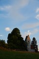
- Wiesenfelden Castle : A former Hofmark castle , is now owned by Hubert Weinzierl . It houses an environmental information center and museum.
- Saulburg Castle : was built in 1569 and its core dates back to the 12th century. It presents itself as an irregular four-wing grouping. In the palace complex is the Catholic palace chapel St. Aegidius, a rococo building from 1754.
Churches


- Parish Church of the Assumption of Mary Wiesenfelden: Was built in 1764 using a Gothic choir and medieval components of the tower and nave. She has remarkable wooden figures from around 1700.
- Filial church St. Georg in Auenzell: built around 1500, baroque; with equipment.
- Pilgrimage Church of St. Magdalena in Heilbrunn: uniform building from 1674; with equipment. The Marian pilgrimage site Heilbrunn has been visited by pilgrims since the 17th century. The pilgrims wash themselves with the healing water of the healing well and hope for healing. The common place name "Brünndl" was derived from it.
- Chapel of Grace of Our Lady: called "Frauenbrünnl" , around 1665; with equipment. Spring house , stone well socket with wooden superstructure, 18./19. century
- Filial church St. Rupertus in Sankt Rupert: late Gothic complex, end of the 15th century; with equipment; Holy grave, cellar-like on the western slope of the church hill, still 18th century; Stations of the Cross, 1865, on the way to the church; Crucifixion group, cast figures, 1870/75; east of the church.
- Expositurkirche Maria Schnee in Saulburg- Anger: nave and tower 1698, extension 1922; with equipment.
- Expositurkirche St. Michael Zinzenzell : new building from 1876; with equipment
In the vicinity
Supraregional hiking trails

Around Wiesenfelden there are 16 marked circular hiking trails with a total length of over 120 kilometers, which are looked after by the Wiesenfelden section of the Bavarian Forest Association. The longest circular hiking trail is the 14.5 km long Große Büscherlweg .
The " Goldsteig " quality hiking trail leads about 18 km through the community. From Weihern bei Wörth an der Donau via Hubmühle, Schiederhof via St. Rupert, it leads along the nature reserve Brandmoos and Weiherlandschaft bei Wiesenfelden to Wiesenfelden. From there over the 110 m long nature observation footbridge over the Beckenweiher , via Utzenzell, Kragenroth, Kesselboden to Pilgramsberg.
The Bavarian Forest Association , Wiesenfelden section, offers guided Goldsteig hikes. The premium trail should be hiked in stages.
Sights
geotopes near Wiesenfelden:

Höllbachtal between Brennberg and Rettenbach, Nepal-Himalaya-Pavillon in Wiesent, Castle Wörth an der Donau , Walhalla in Donaustauf, pile near Roding , castle ruin Lobenstein in cell, castle ruins victory stone at Süssenbach, castle in Brennberg , castle ruins Neuhaus in Schorndorf .
Sports and clubs
There are well-developed sports facilities in Wiesenfelden and in the community. The sports club Wiesenfelden e. V. offers, for example, a wide range of sports with football, tennis, table tennis, ladies' gymnastics, children's and youth gymnastics and has a ski department. There are a total of 60 clubs in the municipality. The Wiesenfelden volunteer fire brigade (founded in 1874) and the fire brigades in the districts provide fire protection and general help in the municipality and beyond.
leisure
On March 1, 2003, the ordinance on the nature reserve Weiherlandschaft near Wiesenfelden came into force. On August 6, 2009 the barrier-free circular path around the pool pond was opened. The path also leads over the 110 meter long nature observation footbridge. Other places to experience nature are the large and small Hammerweiher, the Neuweiher and the "Brandmoos" moor.
Nature observation path around the Kobelberg: 9 different nature observation stations are set up on a 5 km long, beautiful forest path, where children and adults can find out more about nature in a playful way. The starting point is the Waldgasthof Schiederhof, about 4 kilometers south of Wiesenfelden. The path is marked with the marker 7. It is also accessible in winter.
The "Felsenkeller", which has been used as a beer warehouse since the 16th century, is now a hiking base on the "Goldsteig" and offers bats quarters in all seasons. Horseback riding and carriage rides are offered in the community. Riding lessons, guided rides, children's leisure time with horses, carriage rides, and if the weather is suitable, horse-drawn sleigh rides in winter. The open-air floating stage at the Beckenweiher is a unique attraction in the district. In the summer months, the pond provides a backdrop for plays and other cultural performances for children and adults.

There are numerous cross-country trails in the municipality:
- Schiederhofer trail, seven kilometers long, moderately difficult
- Höhenberger trail, eight kilometers long, moderately difficult
- Heilbrunner-Geraszeller trail, twelve kilometers long, moderately difficult
- Connecting trail to Falkenstein, five, eleven or 17 km long, moderately difficult
Winter sports on the village pond
- Ice stock sport or ice skating
Tobogganing on numerous mountain slopes throughout the municipality.
Winter hiking
- 20 kilometers of paths and connecting roads are cleared for hiking in winter.
Winter Nordic walking
- On suitable winter hiking trails.
Regular events
There are numerous “Bavarian music bands” in the municipality. Every year there is a musical summer freshness (musical morning pint). There are also:
- Spring market with spring exhibition
- Pigeon, small animal and farmers market
- Christmas market
- Songs am See (1-day festival on the stage at the Beckenweiher)
Natural monuments

Jägershof – Linde
Sankt Rupert Linde


Jägershof – Linde
⊙ Thewinter lindentree,designatedas anatural monument(ND – No. 28)with a chest height of 8.71 m (2013), stands on a courtyard property in the Jägershöfen district. After a few meters, its mighty trunk divides into several steeply rising main branches, which together form a magnificent and very high crown. A laser-assisted height determination in 2013 showed a tree height of 31 m. The age of the tree is given as around 400 years.
Sankt Rupert Linde
⊙ Thesummer linden treewith a chest height circumference of 7.54 m (2013), which isanother natural monument (ND – No. 24) of the community,is located at the Catholic branch church St. Rupertus in the district of St. Rupert. The two-stemmed tree veteran forms a uniform appearing crown with its two stems, also 31 m high. The age of the monumental linden tree is estimated to be 300–600 years, depending on the source.
Economy and Infrastructure
Wiesenfelden has an intact infrastructure. There is good medical care, a pharmacy, a retirement and nursing home, assisted living, a post office and banks as well as numerous commercial, craft and service companies.
economy
There are several industrial parks in the municipality. In addition, the place is innovative and belongs to the Bavarian Forest model region for electromobility . In this project, an electric vehicle is rented to interested citizens.
Wiesenfelden is a GMO-free region in Bavaria. The farmers have decided to forego genetic engineering entirely. In addition, a community of interest for a "Liveable Wiesenfelden" has set itself the task of educating people about the dangers of mobile communications, electrosmog and genetic engineering.
tourism
A tourist office has been set up for the needs of vacationers and day trippers.
Working group of the Upper Bavarian Forest
On January 8, 2007, the working group for the Vorderer Bayerischer Wald, or “AG Vorwald” for short, was founded. The aim of the working group is to promote and strengthen the region in terms of tourism, economy and culture. Members of this community are the communities Altenthann , Bernhardswald , Brennberg , Falkenstein, Michelsneukirchen , Rettenbach , Wald , Wiesenfelden, Zell and the city of Wörth an der Donau , as well as all local, tourism and tourist associations in these communities.
traffic

In the municipality near Bogenroith there is a rotating radio beacon for aviation navigation .
The places Wiesenfelden and Saulburg are connected to the federal highway 3 by the state road 2148 in the direction of Kirchroth . Wiesenfelden can also be reached via Geraszell and Heilbrunn on State Road 2648. The town of Zinzenzell can be reached from the B20 via State Road 2147.
The place is also well connected to the public transport network to Straubing, Wörth an der Donau, Regensburg and Bogen. A leisure bus organized by the community runs from Wiesenfelden to Straubing.
Public facilities
There are the following municipal institutions in Wiesenfelden:
- Kindergartens in Wiesenfelden and Zinzenzell
- Community library
- Citizens' Hall in the New Town Hall
- Recycling center
- Sewage treatment plant
education and Science
The primary and secondary school is located in Wiesenfelden. There is also a branch of the Volkshochschule Straubing-Bogen in Wiesenfelden. There is a foundation for environmental support in the Wiesenfelden Castle.
The members of the school association are:
- Middle School Association Wörth-Wiesent, consisting of the city of Wörth an der Donau , Wiesent municipality, Pfatter municipality, Bach an der Donau municipality
- Middle School Association Falkenstein, consisting of the market Falkenstein, municipality Rettenbach , municipality Brennberg
- Wiesenfelden community
media
The Donau-Post and the Bogener-Zeitung , as local editions of the Straubinger Tagblatt and the Straubinger Wochenblatt , an edition of the Wochenblatt publishing group , are widespread in the municipality .
Personalities
- Valentin Faltlhauser (1876–1961), psychiatrist and T4 expert
- Oskar Sattler (1920–2006), hairdresser and bandmaster. Winner of the Josef Schlicht Medal (1995).
Honorary citizen
- Anton Windhager, pastor
- Joseph Kilger (born January 18, 1865 - † May 20, 1941), pastor
- Sebastian Schuder, pastor
- Hans Schöx, Count's land manager
- Friedrich Kiendl, pastor
- Alois Saller, Monsignor
- Michael Högerl, Former Mayor
Individual evidence
- ↑ "Data 2" sheet, Statistical Report A1200C 202041 Population of the municipalities, districts and administrative districts 1st quarter 2020 (population based on the 2011 census) ( help ).
- ↑ a b Local elections in the district of Straubing-Bogen. District Sraubing-Bogen, accessed on May 30, 2020 .
- ^ Community Wiesenfelden in the local database of the Bayerische Landesbibliothek Online . Bavarian State Library
- ↑ District. Municipalities and districts. Bavarian Surveying Administration, archived from the original on April 11, 2013 ; accessed on March 31, 2015 .
- ↑ Inauguration of the Death Marches Memorial Website Around the Edenhof - Margit Wenger-Schott. Retrieved May 30, 2016.
- ↑ a b Bavarian State Office for Statistics and Data Processing (Hrsg.): The municipalities of Bavaria according to the territorial status May 25, 1987. The population of the municipalities of Bavaria and the changes in the property and territory from 1840 to 1987 (= contributions to Statistics Bavaria . Issue 451 ). Munich 1991, p. 70–72 , urn : nbn: de: bvb: 12-bsb00070717-7 ( digitized version ).
- ^ Wilhelm Volkert (ed.): Handbook of Bavarian offices, communities and courts 1799–1980 . CH Beck, Munich 1983, ISBN 3-406-09669-7 , p. 437 .
- ^ Federal Statistical Office (ed.): Historical municipality directory for the Federal Republic of Germany. Name, border and key number changes in municipalities, counties and administrative districts from May 27, 1970 to December 31, 1982 . W. Kohlhammer GmbH, Stuttgart / Mainz 1983, ISBN 3-17-003263-1 , p. 631 .
- ^ Max Piendl, Ludwig Holzfurtner: Mitterfels . Historical Atlas of Bavaria. Ed .: Commission for Bavarian State History at the Bavarian Academy of Sciences. Part Altbayern, issue 62. Munich 2002, ISBN 3-7696-9695-6 , p. 648 .
- ↑ M. Gross, "Wiesenfelden", 1977
- ↑ Bavarian State Statistical Office (ed.): Official city directory for Bavaria, territorial status on October 1, 1964 with statistical information from the 1961 census . Issue 260 of the articles on Bavaria's statistics. Munich 1964, DNB 453660959 , Section II, Sp. 285 ( digitized version ).
- ^ Bavarian State Statistical Office (ed.): Official place directory for Bavaria . Issue 335 of the articles on Bavaria's statistics. Munich 1973, DNB 740801384 , p. 117 ( digitized version ).
- ↑ Bavarian State Office for Statistics and Data Processing (Ed.): Official local directory for Bavaria, territorial status: May 25, 1987 . Issue 450 of the articles on Bavaria's statistics. Munich November 1991, DNB 94240937X , p. 241 ( digitized version ).
- ^ Bavarian State Office for Statistics. Wiesenfelden community. Municipal statistics 2015 PDF, Munich 2016, p. 6.
- ↑ Local election 2014: [1] Wiesenfelden
- ↑ "Jägershof-Linde in Hunter courts / Wiesenfelden" in the tree register in www.baumkunde.de
- ↑ "Winter lime tree 'Jägershof-Linde' at Jägershöfen in Wiesenfelden" in Monumental Trees at monumentaltrees.com
- ^ Wiesenfelden in the directory of monumental oaks . Retrieved February 5, 2017
- ↑ "Linde bei Wiesenfelden" in the tree register, at www.baumkunde.de
- ^ Arbeitsgemeinschaft Vorderer Bayerischer Wald [2] , accessed on December 26, 2014.
- ↑ Wiesenfelden primary school in the school database of the Bavarian State Ministry for Education and Culture , accessed on August 6, 2017.
- ↑ Middle School Wiesenfelden in the school database of the Bavarian State Ministry for Education and Culture , accessed on August 6, 2017.
literature
- Harald Stark : The Notthracht family - looking for traces in Egerland, Bavaria and Swabia , Weißenstadt 2006, ISBN 3-926621-46-X
- Manfred Gross: Wiesenfelden, Landscape and History , Wiesenfelden 1978
Web links
- Website of the municipality of Wiesenfelden
- Entry on the coat of arms of Wiesenfelden in the database of the House of Bavarian History

Aholfing | Aiterhofen | Ascha | Atting | Bow | Falkenfels | Feldkirchen | Geiselhöring | Haibach | Haselbach | Hunderdorf | Irlbach | Kirchroth | Konzell | Laberweinting | Leiblfing | Loitzendorf | Mallersdorf-Pfaffenberg | Mariaposching | Mitterfels | Neukirchen | Niederwinkling | Oberschneiding | Parkstetten | Perasdorf | Perkam | Rain | Rattenberg | Rattiszell | Salching | Sankt Englmar | Schwarzach | Stallwang | Steinach | Straßkirchen | Wiesenfelden | Windberg