
Wiesent (Danube)
|
Wiesent upper course: Filzmoosbach , Neumühlbach , Arracher Bach and Höllbach |
||
 The Wiesent near Wörth on the Danube |
||
| Data | ||
| Water code | EN : 1552 | |
| location | Bavaria , Germany | |
| River system | Danube | |
| Drain over | Danube → Black Sea | |
| source | In the Falkensteiner Vorwald near Wiesenfelden 49 ° 3 ′ 6 ″ N , 12 ° 34 ′ 41 ″ E |
|
| Source height | 652 m above sea level NN | |
| muzzle | Between Wörth an der Donau and Niederachdorf in the Danube Coordinates: 48 ° 58 ′ 11 ″ N , 12 ° 26 ′ 16 ″ E 48 ° 58 ′ 11 ″ N , 12 ° 26 ′ 16 ″ E |
|
| Mouth height | 320 m above sea level NN | |
| Height difference | 332 m | |
| Bottom slope | 13 ‰ | |
| length | 25.3 km | |
| Catchment area | 72 km² | |
| Left tributaries | Perlbach , Wörther Bachl, Rupertsbühler Bach, | |
| Right tributaries | Deßgraben, Augraben | |
| Small towns | Wörth on the Danube | |
| Communities | Wiesenfelden , Falkenstein , Rettenbach , Brennberg , Wiesent | |
The Wiesent , in the upper reaches of Höllbach , is a brook in the Upper Palatinate that flows into the Danube between Wörth an der Donau and Niederachdorf .
From the confluence of the Rupertsbühler Bach west of Dietersweg , Wiesent municipality , to the confluence with the Danube below Tiefenthal , town of Wörth an der Donau , it is a second-order body of water.
The name gives the place Wiesent, read as Wisent fl. On Philipp Apian's land table 7 from 1568. The brook has its origin in the Falkensteiner Vorwald near Wiesenfelden as an outflow of the Hammerweiher. It bears the name Arracher Bach up to the Rettenbach reservoir , from Rettenbach the name Höllbach, from the mouth of the Rupertsbühler Bach near Heilsberg it is called Wiesent. Historically there were still the names Hammerbach and Postfeldner Bach for sections of the upper course, the lower course was called Wildbach.
Tributaries are the Perlbach, the Heßgraben and the Schrollenbach. The Wiesent and its upper reaches flow through the places Wiesenfelden, Neumühle, Hammermühl , Arrach , Rettenbach , Postfelden , Fahnmühle , Heilsberg , Waffenschmiede , Wiesent and Oberachdorf .
Use of hydropower
The stream is dammed up several times to form lakes. In 1933 the Höllbach power station 1 was built below the Heilsberger mill. It draws its water through a 960 meter long pressure pipe with a gradient of 47 meters from an equalization basin above the Heilsberger Mühle. Höllbachkraftwerk 2 from 1951 is located on this basin, its pressure line is 2.2 kilometers long and is fed from the basin below Fahnmühle, with a height difference of 67.5 meters. The Höllbach power plant 3, completed in 1961, is located above Fahnmühle and receives its water from the Postfelden reservoir, which is 85 meters higher and is connected to the power plant via a 1190-meter-long penstock.
A hiking trail runs along the stream between Heilsberg and Postfelden, which leads below Postfelden through the Hölle nature reserve . Before it flows into today's Danube, the Wiesent flows through the old arm of the river known as the "Old Danube" in the Gmünder Au nature reserve .
gallery

Hammerweiher, origin of the Wiesent
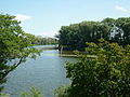
"Old Danube" - the branch of the Wiesent near Wörth on the Danube
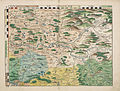
Bavarian country tables from 1568 (panel 7)


Web links
Individual evidence
- ↑ a b BayernAtlas of the Bavarian State Government ( notes )
- ↑ a b Map service water management, WFD Bavarian State Office for the Environment ( information )
- ^ Second order waters . In: General Ministerialblatt . No. 2, 2016, p. 152-167 ( online [PDF]).
- ↑ Philipp Apian: Plate 7 . In: Bavarian country tables . 1568 ( online ).
- ↑ Directory of creek and river areas in Bavaria - Naab to Isar river area of the Bavarian State Office for the Environment, as of 2016 (PDF; 2.8 MB)
- ^ Eisenmann, Joseph Anton; Hohn, Karl Friedrich (Ed.): Topo-geographical-statistical lexicon from the Kingdom of Bavaria, or .. 1831, p. 776 ( digitized version - "Höllbach, also Arrachbach, Hammerbach, Postfeldner Bach, Bach im Ldg. Mitterfels, which arises from the Hammerweiher near Wiesenfelden and flows south by Postfelden.").
- ^ Repertory of the topographical atlas sheet .... [48], Regensburg . 1819, p. 51 ( digitized version ).
- ↑ The history of the Höllbach power plants