Saulburg
|
Saulburg
Community Wiesenfelden
Coordinates: 48 ° 59 ′ 29 ″ N , 12 ° 33 ′ 8 ″ E
|
||
|---|---|---|
| Residents : | 344 (2012) | |
| Incorporation : | May 1, 1978 | |
| Postal code : | 94344 | |
| Area code : | 09428 | |
|
Location of Saulburg in Bavaria |
||
|
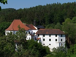
Saulburg Castle
|
||
Saulburg is a parish village and part of the municipality Wiesenfelden in the Lower Bavarian district of Straubing-Bogen . Until 1978 Saulburg formed an independent municipality.
location
Saulburg is located in the Bavarian Forest about five kilometers south of Wiesenfelden on a prominent mountain ledge.
history
In the traditional code of Windberg Monastery , which began before 1150 and ends before 1191, a Heinrich de Sulperge is mentioned, which is also the first written mention of Saulburg. For centuries, Saulburg has been named in the documents Sulperge , Suleberch or Saulperch , which originally means " pillar mountain ".
Saulburg Castle from around 1150 to 1190 is still defining the townscape today. The Hofmark Saulburg had an eventful history. With a drawing of lots on June 29, 1429, which took place on the basis of the Pressburg arbitration award of April 26, 1429, the Saulburg fortress came to Duke Wilhelm III. of Bavaria .
The municipality of Saulburg was subordinate to the district court Mitterfels and later belonged to the district and district of Bogen . In the course of the regional reform in Bavaria , Mayor Ring expressed skepticism in a letter to the Ministry of the Interior regarding possible amalgamation of the municipalities. The Saulburgers saw an administrative community with similarly structured neighboring communities as a lesser evil . A connection to the municipality of Parkstetten was considered most likely , and a connection to the municipality of Kirchroth was also expected. On May 1, 1978, the community of Saulburg was largely incorporated into the community of Wiesenfelden, while the community parts Aufroth, Neumühl and Neuroth came to the community of Kirchroth.
Districts of the former municipality of Saulburg
|
Population development in the Saulburg district
| year | 1875 | 1885 | 1900 | 1925 | 1950 | 1961 | 1970 | 1987 |
|---|---|---|---|---|---|---|---|---|
| Residents | 180 | 186 | 188 | 214 | 227 | 190 | 228 | 249 |
Attractions
- Expositurkirche Maria Schnee. The nave and tower were built in 1698 and expanded in 1922.
-
Saulburg Castle . The complex, built on a rocky outcrop, dates back to the 12th century and is a conglomerate of buildings from the 12th to the 18th century. The Gothic residential building has a Renaissance arcade.
- Castle chapel St. Aegidius. It is a Rococo building by the master builder Johann Fischer from 1754 with Tuscan pilasters .
literature
- Christoph Sedlmaier: Description of the coin find near Saulburg in Lower Bavaria. In: Negotiations of the historical association for Lower Bavaria . 3rd volume, 4th issue. Landshut 1854, p. 68-70 ( digitized version ).
Web links
- Saulburg in the location database of the Bavarian State Library Online . Bavarian State Library
- Michel Wellenhofer: History about Saulburg and the surrounding area , Saulburg and its history
Individual evidence
- ^ Dorit-Maria Krenn: Straubinger Erbfall, 1425-1429. In: Historical Lexicon Bavaria. Bavarian State Library, accessed on June 6, 2017 .
- ↑ Kgl. Statistical Bureau (ed.): Complete list of localities of the Kingdom of Bavaria. According to districts, administrative districts, court districts and municipalities, including parish, school and post office affiliation ... with an alphabetical general register containing the population according to the results of the census of December 1, 1875 . Adolf Ackermann, Munich 1877, 2nd section (population figures from 1871, cattle figures from 1873), Sp. 406 , urn : nbn: de: bvb: 12-bsb00052489-4 ( digitized version ).
- ↑ K. Bayer. Statistical Bureau (Ed.): Localities directory of the Kingdom of Bavaria. According to government districts, administrative districts, ... then with an alphabetical register of locations, including the property and the responsible administrative district for each location. LIV. Issue of the contributions to the statistics of the Kingdom of Bavaria. Munich 1888, Section III, Sp. 385 ( digitized version ).
- ↑ K. Bayer. Statistical Bureau (Ed.): Directory of localities of the Kingdom of Bavaria, with alphabetical register of places . LXV. Issue of the contributions to the statistics of the Kingdom of Bavaria. Munich 1904, Section II, Sp. 392 ( digitized version ).
- ↑ Bavarian State Statistical Office (ed.): Localities directory for the Free State of Bavaria according to the census of June 16, 1925 and the territorial status of January 1, 1928 . Issue 109 of the articles on Bavaria's statistics. Munich 1928, Section II, Sp. 405 ( digitized version ).
- ↑ Bavarian State Statistical Office (ed.): Official place directory for Bavaria - edited on the basis of the census of September 13, 1950 . Issue 169 of the articles on Bavaria's statistics. Munich 1952, DNB 453660975 , Section II, Sp. 379 ( digitized version ).
- ↑ Bavarian State Statistical Office (ed.): Official city directory for Bavaria, territorial status on October 1, 1964 with statistical information from the 1961 census . Issue 260 of the articles on Bavaria's statistics. Munich 1964, DNB 453660959 , Section II, Sp. 283 ( digitized version ).
- ^ Bavarian State Statistical Office (ed.): Official place directory for Bavaria . Issue 335 of the articles on Bavaria's statistics. Munich 1973, DNB 740801384 , p. 116 ( digitized version ).
- ↑ Bavarian State Office for Statistics and Data Processing (Ed.): Official local directory for Bavaria, territorial status: May 25, 1987 . Issue 450 of the articles on Bavaria's statistics. Munich November 1991, DNB 94240937X , p. 241 ( digitized version ).

