
Parkstetten
| coat of arms | Germany map | |
|---|---|---|

|
Coordinates: 48 ° 55 ' N , 12 ° 36' E |
|
| Basic data | ||
| State : | Bavaria | |
| Administrative region : | Lower Bavaria | |
| County : | Straubing arch | |
| Height : | 319 m above sea level NHN | |
| Area : | 19.51 km 2 | |
| Residents: | 3238 (Dec. 31, 2019) | |
| Population density : | 166 inhabitants per km 2 | |
| Postal code : | 94365 | |
| Area code : | 09421 | |
| License plate : | SR , BOG, MAL | |
| Community key : | 09 2 78 170 | |
| LOCODE : | DE PTE | |
| Community structure: | 16 districts | |
| Address of the municipal administration: |
Schulstraße 3 94365 Parkstetten |
|
| Website : | ||
| Mayor : | Martin Panten ( SPD ) | |
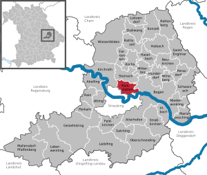
| Location of the municipality of Parkstetten in the district of Straubing-Bogen | ||
  |
||

Parkstetten is a municipality in the Lower Bavarian district of Straubing-Bogen .
geography
Geographical location
Parkstetten lies to the left of the Danube and borders the city of Straubing in the south . Parkstetten is surrounded by numerous ponds and is located in the Bavarian Forest Nature Park .
Community structure
Parkstetten has 16 districts, ten of which are in the original municipality, five in the former municipality of Unterzeitldorn and the former municipality of Reibersdorf:
|
There are the districts Parkstetten and Reibersdorf.
history
The first written mention of the place Parkstetten comes from the year 1216. Parkstetten belonged to the Rentamt Straubing and to the district court Mitterfels of the Electorate of Bavaria .
Incorporations
On January 1, 1973, the previously independent municipality of Reibersdorf was incorporated. On July 1, 1976, parts of the dissolved community of Unterzeitldorn (Bielhof, Fischerdorf, Friedenhain, Oberharthof and Unterharthof) were added.
Population development
- 1840: 629 inhabitants
- 1939: 1087 inhabitants
- 1961: 1465 inhabitants, 1158 of them in Parkstetten, 171 in Reibersdorf and 136 in the area of Unterzeitldorn, which was later incorporated
- 1970: 1770 inhabitants, 1418 of them in Parkstetten, 208 in Reibersdorf and 144 in the area of Unterzeitldorn, which was later incorporated
- 1972: 1770 inhabitants, of which 1357 in Parkstetten, 208 in Reibersdorf and 205 in the rest of the area
- 1975: 1820 inhabitants
- 1987: 2249 inhabitants
- 1991: 2358 inhabitants
- 1995: 2640 inhabitants
- 2000: 2769 inhabitants
- 2005: 2980 inhabitants
- 2010: 3014 inhabitants
- 2015: 3107 inhabitants
On September 24, 2005, the third thousand was full. Parkstetten has since had the character of a typical suburban community with extensive residential areas.
In the period from 1988 to 2018, the municipality grew from 2,261 to 3,216 by 955 inhabitants or 42.2%.
politics
Martin Panten (SPD / FWG) has been the first mayor since May 2020. His predecessors were Heinrich Krempl (CSU, 2008–2020), Alfons Schießwohl (SPD / FWG, 1996–2008) and Ludwig Schneider (CSU, 1972–1996).
Other mayors since May 2020 are:
- Second Mayor: Franz Listl (SPD / FWG)
- Third Mayor: Peter Seubert (ÖDP / PU)
Architectural monuments

- Parish church of St. Georg in Parkstetten. The parish is an original parish with a long history. In 1986 a new church was consecrated. The choir and the tower of the previous church as well as the furnishings from the Baroque and Rococo periods have been preserved.
- Expositurkirche St. Martin in Reibersdorf
Economy and Infrastructure
Economy including agriculture and forestry
In 1998, according to official statistics, there were five employees in the field of agriculture and forestry, 258 in manufacturing and 75 in trade and transport at the place of work. In other economic sectors 119 people were employed at the place of work subject to social security contributions. There were a total of 965 employees at the place of residence subject to social security contributions. There were four companies in the manufacturing sector and five in the construction sector. In addition, in 1999 there were 43 farms with an agriculturally used area of 749 ha, of which 89 ha were permanent green space.
education
There are the following facilities:
- Day care center with around 100 children
- Dr.-Johann-Stadler-Grundschule Parkstetten with eight teachers and 134 students (as of 2018/2019)
- Dr.-Johann-Stadler-Mittelschule Parkstetten with two teachers and 15 students (as of 2018/2019)
Personalities
- Johann Evangelist Stadler (1804–1868), the "Lower Bavarian Mezzofanti"
There are currently two honorary citizens: BGR Josef Gresik and former mayor Alfons Schießwohl.
Thomas Mayer, known as Vogelmayer (* 1981), German cabaret artist and songwriter, grew up in Parkstetten.
Individual evidence
- ↑ "Data 2" sheet, Statistical Report A1200C 202041 Population of the municipalities, districts and administrative districts 1st quarter 2020 (population based on the 2011 census) ( help ).
- ↑ a b Local elections in the district of Straubing-Bogen. District Sraubing-Bogen, accessed on May 30, 2020 .
- ^ Parish Parkstetten in the local database of the Bavarian State Library Online . Bavarian State Library
- ↑ District. Municipalities and districts. Bavarian Surveying Administration, archived from the original on April 11, 2013 ; accessed on March 31, 2015 .
- ↑ a b c d Federal Statistical Office (Hrsg.): Historical municipality register for the Federal Republic of Germany. Name, border and key number changes in municipalities, counties and administrative districts from May 27, 1970 to December 31, 1982 . W. Kohlhammer GmbH, Stuttgart / Mainz 1983, ISBN 3-17-003263-1 , p. 631 .
- ↑ Kita Parkstetten
- ↑ Dr.-Johann-Stadler-Grundschule Parkstetten in the school database of the Bavarian State Ministry for Education and Culture , accessed on May 2, 2020.
- ↑ Dr.-Johann-Stadler-Mittelschule Parkstetten in the school database of the Bavarian State Ministry for Education and Culture , accessed on May 2, 2020.
Web links
- Entry on the Parkstetten coat of arms in the database of the House of Bavarian History

Aholfing | Aiterhofen | Ascha | Atting | Bow | Falkenfels | Feldkirchen | Geiselhöring | Haibach | Haselbach | Hunderdorf | Irlbach | Kirchroth | Konzell | Laberweinting | Leiblfing | Loitzendorf | Mallersdorf-Pfaffenberg | Mariaposching | Mitterfels | Neukirchen | Niederwinkling | Oberschneiding | Parkstetten | Perasdorf | Perkam | Rain | Rattenberg | Rattiszell | Salching | Sankt Englmar | Schwarzach | Stallwang | Steinach | Straßkirchen | Wiesenfelden | Windberg