
Oberschneiding
| coat of arms | Germany map | |
|---|---|---|

|
Coordinates: 48 ° 48 ' N , 12 ° 39' E |
|
| Basic data | ||
| State : | Bavaria | |
| Administrative region : | Lower Bavaria | |
| County : | Straubing arch | |
| Height : | 354 m above sea level NHN | |
| Area : | 60.77 km 2 | |
| Residents: | 3093 (Dec. 31, 2019) | |
| Population density : | 51 inhabitants per km 2 | |
| Postal code : | 94363 | |
| Area code : | 09426 | |
| License plate : | SR , BOG, MAL | |
| Community key : | 09 2 78 167 | |
| LOCODE : | DE XOS | |
| Community structure: | 34 districts | |
| Address of the municipal administration: |
Pfarrer-Handwercher-Platz 4 94363 Oberschneiding |
|
| Website : | ||
| Mayor : | Ewald Seifert ( CSU ) | |
| Location of the municipality of Oberschneiding in the Straubing-Bogen district | ||
  |
||

Oberschneiding is a municipality in the Lower Bavarian district of Straubing-Bogen .
geography

Geographical location
Oberschneiding lies at the transition from the Gäuboden to the Lower Bavarian hill country (also called the Tertiary hill country ). The community is located in the south of the Straubing-Bogen district . The district of Dingolfing-Landau borders the municipality in the south and east .
While the northern part of the municipality is in the Gäuboden and thus in the Danube plain , the villages in the east of the municipality are already in the Isar valley .
The town of Oberschneiding is located about ten kilometers south of Straubing and about 13 kilometers north of Landau an der Isar .
From Oberschneiding you can see the Gäuboden and the city of Straubing as well as the Bavarian Forest to the north of it, and when the visibility is good you can see the Alps from the hills near Reissing .
Community structure
Oberschneiding has 34 districts:
There are the districts Grafling, Großenpinning, Niederschneiding, Oberpiebing, Oberschneiding, Reissing and Wolferkofen.
history
Neolithic
The area around Oberschneiding was settled over 7000 years ago. In addition to the fertile soil, it was probably the manageability of the surroundings and the proximity to the waters of the Irlbach that prompted the people of the Neolithic to settle here. Numerous finds of skeletons, ceramic shards and smelter clay bear witness to the settlement . From around 4000 BC Numerous finds were made in the area of Münchshöfen, which gave the period the name " Münchshöfen culture ". Parts of the finds from the municipality can be viewed in the Gäubodenmuseum Straubing.
First documentary mention
It was first mentioned in a document in 790. In the Brevivarius Urolfi, an inventory of the Niederaltaich monastery , "Snudinga" is mentioned. The name "Snudinga" goes back, like most places ending in -ing, to the leader of a Bavarian clan who settled there as part of the Bavarian conquest around 500 AD. The name of the clan chief is likely to have been Snudo. From the name “Snudinga” the name “Schneiding” developed over time. The 1200th anniversary was celebrated in 1990 with festivities lasting several days.
Urhof of Oberschneiding
Initially, the Snudo clan probably built a courtyard, which was the starting point for today's settlement. This settlement, known as the Urhof , is still relatively easy to understand today, as ownership hardly changed from the Middle Ages to the 19th century. The Urhof was characterized by large fields in the immediate vicinity of the homestead. Most of the time, the first churches that were built in the course of Christianization from 700 AD were built near the Urhof. This means that there are essentially three properties that still existed around 1800 for the Urhof in Oberschneiding: the Hiergeisthof (today the country bakery, Pfarrer-Handwercher-Platz 1), the Rammelhof (Feuerhausstraße 2) and the Burghof (Straubinger Straße 1).
This theory contrasts with the fact that it has not yet been clarified whether the original Snudinga in the Brevivarius Urolfi meant Oberschneiding or Niederschneiding.
Hofmark Oberschneiding
From 1319 to 1801 Oberschneiding was an open Hofmark , the seat was in Hienhart . Oberschneiding initially belonged to the Straubing Rent Office of the Duchy - and later the Electorate of Bavaria and then to the Straubing Regional Court of the Kingdom of Bavaria .
In 1802 the Oberschneiding patrimonial court was established with its seat in Hienhart, to which Strähberg and Niederwalting also belonged. In the course of the administrative reforms in Bavaria , the municipality was created with the municipal edict of 1818 . In the revolutionary year of 1848 the patrimonial court was dissolved.
Incorporations
Today's community was created through the regional reforms in 1972 and 1978. On January 1, 1972, the previously independent communities Niederschneiding and Wolferkofen were incorporated. On May 1, 1978 the community of Großenpinning followed, until then in the district of Dingolfing-Landau , the community of Reissing, and from the community of Grafling the districts of Münchsdorf, Peinkofen and Grafling, and Riedling from the community of Oberpiebing .
Population development
In the period from 1988 to 2018, the municipality grew from 2,391 to 3,003 by 612 inhabitants or 25.6%.
Church as it is today
- 1961: 2809 inhabitants
- 1970: 2619 inhabitants
- 1987: 2419 inhabitants
- 1991: 2447 inhabitants
- 1995: 2622 inhabitants
- 2000: 2689 inhabitants
- 2005: 2757 inhabitants
- 2010: 2764 inhabitants
- 2015: 2806 inhabitants
Location Oberschneiding
- 1961: 519 inhabitants
- 1970: 508 inhabitants
- 1987: 588 inhabitants
- 2017: 1226 inhabitants

politics
Result of the local election
The local elections on March 16, 2014 produced the following results:
| Party / political grouping | Share of votes | change | Seats | change |
|---|---|---|---|---|
| CSU | 77.0% | -2.3 | 11 | ± 0 |
| ödp / party-free active citizens | 23.0% | +2.3 | 3 | ± 0 |
mayor
Ewald Seifert (CSU) has been mayor since 2002. In 2017 he received the municipal medal of merit in bronze. In the 2020 election he was re-elected with 58.13%.
coat of arms

Blazon: split of gold and red with a green heart shield, in it five golden ears of corn; in front a growing, bearded man with a blue skirt belted in the middle and clad with five gold buttons, crowned gold, who holds a silver sword in his right hand, behind a left-turning jumping greyhound.
The figure of the crowned man with sword comes from the coat of arms of the Dürnizl family, who owned Hofmark Oberschneiding from 1643 to 1848. The jumping greyhound symbolizes the close connection to Windberg Monastery , which was also rich in the area of the community. The five ears of corn in the heart sign refer to the grain cultivation in the Gäuboden community and also remind us that Oberschneiding has been made up of five formerly independent communities (Oberschneiding, Niederschneiding, Wolferkofen, Großenpinning, Reissing) since the local regional reform in 1972/78.
Culture and sights
education
There is now a primary school in the Oberschneiding community. In the summer of 2007, the Oberschneiding elementary school celebrated its 25th anniversary. The school has been located on the new school and sports grounds on the southern outskirts of Oberschneiding since 1982. Previously, the pupils of the Oberschneiding elementary school were divided into five school buildings in Oberschneiding (girls' school and boys' school), Reissing (monastery school and former boys' school) and Münchshöfen. Since the school year 2004/05 there has only been one elementary school in the municipality of Oberschneiding, as the lower secondary school could no longer be maintained due to educational reforms and a general decline in the number of pupils.
There is also a kindergarten in Oberschneiding and in Reissing. A day nursery has also existed in Oberschneiding since September 2010.
Attractions
- Catholic parish church of the Assumption in Oberschneiding; Altar house, crossing and tower from the 18th century, extension of the nave to the west and extension by two transepts in 1848, redesign from 1910 to 1914 probably by Heinrich Hauberrisser , exterior renovation 2005/2006
- Catholic parish church Maria Immaculata in Reissing; essentially old components, almost completely rebuilt in the 19th century above the previous church.
- Catholic branch church St. Petrus in Niederschneiding (around 1720)
- Catholic branch church St. Bartholomäus in Riedling (18th century, vestibule added in 19th century)
- Catholic branch church St. Elisabeth in Büchling (12th / 13th century, tower baroque)
- Catholic branch church St. Peter and Paul in Grafling (uniform new building from 1712)
- Catholic branch church St. Emmeram and Kassian in Großenpinning (second half of the 15th century, sacristy 1865)
- Catholic branch church of St. Giles in Wolferkofen (late Gothic building around 1480/90, baroque)
- Catholic branch church St. Pantaleon in Lichting (uniform construction around 1750)
- Catholic Church St. Sebastian in Münchshöfen (choir and tower substructure late Gothic, nave 18th century)
- Hienhart Castle ; Residential building with half hipped roof (privately owned), built in the 17th century, reworked in the 2nd half of the 18th century
- Palace Chapel of Our Lady of Sorrows in Hienhart (1730)
- Rural stable house in Taiding (privately owned); richly painted upper floor block building, probably 1st third of the 19th century

Parish church Oberschneiding with church forecourt
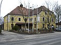
Town hall Oberschneiding


Economy and Infrastructure
Economy including agriculture and forestry
According to official statistics, there were 29 employees at the place of work in the field of agriculture and forestry, 113 in the manufacturing sector and 38 in trade and transport. In other economic sectors, 140 people were employed at the place of work subject to social security contributions. There were a total of 765 employees at the place of residence subject to social insurance contributions. There were 13 companies in the manufacturing sector and three in the construction sector. In addition, there were 162 farms in 1999 with an agricultural area of 4818 ha, of which 4735 ha were arable land and 82 ha were permanent green space.
Siebenkofen industrial park
Since the completion of the development work in spring 2007, a closed industrial area has existed in the Oberschneiding community for the first time. It is located on the outskirts of Siebenkofen on county road 72, about one kilometer away from federal road 20.
traffic
Oberschneiding has access to the A 3 ( Regensburg - Passau ) and A 92 ( Deggendorf - Munich ) motorways through the federal road 20 , which crosses the municipality in a north-south direction . Since the construction of the B 20 in 1989, all places in the municipality have bypasses.
Personalities

- Mathias Obermayr (born May 14, 1720 in Meindling, † December 15, 1799), plasterer and sculptor, created numerous rococo altars and pulpits, including in the St. Jakob Basilica in Straubing, in the Metten and Windberg Abbeys;
- Franz Sales Handwercher (born June 3, 1792; † August 17, 1853 in Oberschneiding), from 1836 to 1853 pastor in Oberschneiding, founder of the Brotherhood of the Most Holy and Immaculate Heart Mariae; built a girls' school (demolished in 1987) and expanded the parish church in Oberschneiding in 1848;
- Josef Schlicht (born March 18, 1832; † April 18, 1917), from 1859 to 1869 cooperator ( chaplain ) in the parish of Oberschneiding, writer and chronicler of rural life; he describes the harvesting work and the people ("The honorable senior farmer" from Niederschneiding, "A Lower Bavarian Jubelsparrer", meaning the pastor Obelt from Reissing, "The brave Plendl farmer" from Großenpinning);
- Alfons Maria Scheglmann (born June 20, 1858 in Oberschneiding; † March 17, 1937), pastor and historian, vicar general in the diocese of Regensburg;
- Max Feldbauer (born February 14, 1869; † November 20, 1948 in Münchshöfen), German Secession painter, spent the last years of his life in Münchshöfen from 1944;
Individual evidence
- ↑ "Data 2" sheet, Statistical Report A1200C 202041 Population of the municipalities, districts and administrative districts 1st quarter 2020 (population based on the 2011 census) ( help ).
- ↑ a b Local elections in the district of Straubing-Bogen. District Sraubing-Bogen, accessed on May 30, 2020 .
- ^ Oberschneiding community in the local database of the Bavarian State Library Online . Bavarian State Library
- ↑ District. Municipalities and districts. Bavarian Surveying Administration, archived from the original on April 11, 2013 ; accessed on March 31, 2015 .
- ^ Wilhelm Volkert (ed.): Handbook of Bavarian offices, communities and courts 1799–1980 . CH Beck, Munich 1983, ISBN 3-406-09669-7 , p. 577 .
- ^ Federal Statistical Office (ed.): Historical municipality directory for the Federal Republic of Germany. Name, border and key number changes in municipalities, counties and administrative districts from May 27, 1970 to December 31, 1982 . W. Kohlhammer GmbH, Stuttgart / Mainz 1983, ISBN 3-17-003263-1 , p. 632 and 633 .
- ↑ Bavarian State Statistical Office (ed.): Official city directory for Bavaria, territorial status on October 1, 1964 with statistical information from the 1961 census . Issue 260 of the articles on Bavaria's statistics. Munich 1964, DNB 453660959 , Section II, Sp. 445 ( digitized version ).
- ^ Bavarian State Statistical Office (ed.): Official place directory for Bavaria . Issue 335 of the articles on Bavaria's statistics. Munich 1973, DNB 740801384 , p. 115 ( digitized version ).
- ↑ Bavarian State Office for Statistics and Data Processing (Ed.): Official local directory for Bavaria, territorial status: May 25, 1987 . Issue 450 of the articles on Bavaria's statistics. Munich November 1991, DNB 94240937X , p. 238 ( digitized version ).
- ↑ Data - An overview of the Oberschneiding community. Retrieved September 20, 2017 (as of August 2017).
- ↑ History of the Oberschneiding School: Archived copy ( memento of the original from September 27, 2007 in the Internet Archive ) Info: The archive link was inserted automatically and has not yet been checked. Please check the original and archive link according to the instructions and then remove this notice.
Web links
- www.oberschneiding.de
- Entry on the coat of arms of Oberschneiding in the database of the House of Bavarian History

Aholfing | Aiterhofen | Ascha | Atting | Bow | Falkenfels | Feldkirchen | Geiselhöring | Haibach | Haselbach | Hunderdorf | Irlbach | Kirchroth | Konzell | Laberweinting | Leiblfing | Loitzendorf | Mallersdorf-Pfaffenberg | Mariaposching | Mitterfels | Neukirchen | Niederwinkling | Oberschneiding | Parkstetten | Perasdorf | Perkam | Rain | Rattenberg | Rattiszell | Salching | Sankt Englmar | Schwarzach | Stallwang | Steinach | Straßkirchen | Wiesenfelden | Windberg
Büchling | Eglsee | Fierlbach | Grafling | Great pinning | Hienhart | Hölldorf | Small pinning | Small taiiding | Lichtenberg | Atrium | Lighting | Lohhof | Meindling | Münchsdorf | Münchshöfen | Neubüchling | Neuhausen | Niederschneiding | Niederwalting | Noisling | Oberschneiding | Padering | Peinkofen | Rainting | Reissing | Rennerhof | Riedling | Schierlhof | Schnatting | Siebenkofen | Straehberg | Taiding | Wolferkofen