Silent king
|
Stilleking nature reserve
|
||
|
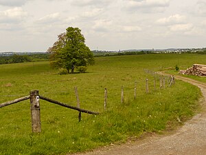
Grassland area in the NSG Stilleking (2009) |
||
| location | Lüdenscheid , Märkischer Kreis , North Rhine-Westphalia , Germany | |
| surface | 152.9 ha | |
| Identifier | MK-043 | |
| WDPA ID | 344783 | |
| Natura 2000 ID | DE-4811-301 | |
| FFH area | 152.54 hectares | |
| Geographical location | 51 ° 11 ' N , 7 ° 38' E | |
|
|
||
| Sea level | from 345 m to 431 m | |
| Setup date | 1994 | |
| Framework plan | Landscape plan Lüdenscheid | |
| administration | Lower landscape authority of the Märkisches Kreis | |
The Stilleking nature reserve (NSG identification MK-043) is located on the southern edge of the North Rhine-Westphalian city of Lüdenscheid . It is around 152.9 hectares and was designated as a nature reserve in 1994 by the district council of the Märkisches Kreis with the landscape plan No. 3 Lüdenscheid , at that time under the NSG name of the Stilleking and Hemecketal military training area . The first change to the landscape plan in 2005 was accompanied by the renaming of the nature reserve in Stilleking . Since 2005, the area has been designated as FFH area DE-4811-301, former military training area Stilleking and Hemecketal , with an almost identical layout , which makes it part of the European Natura 2000 network of protected areas .
history
The name Stilleking goes back to an old farm location in the east just outside the nature reserve. There is a prominent tree on a path along the NSG border, the so-called Lehngerichts linde.
The area was used as a military training area from the 1930s to 1992 ; also armored practiced on the premises.
Area description
In the NSG Stilleking , habitats that have become very rare in the natural area Märkisches Oberland , u. a. larger heathland placed under protection. In addition to open land areas, smaller beech forests and stream-accompanying alder forests are particularly characteristic of the natural area . The former military training area forms an extensive, nutrient-poor area and essentially consists of large, hilly, lean grassland complexes, which are divided into individual areas with a diameter of sometimes more than 500 m by forest areas, strips of wood and groups of trees. The grassland areas range from dry to damp and soaked. In addition, there are small fragments of grass turf, dwarf shrub heather and dry silicate lawns. As a result of the abandonment of use, almost all lean grassland biotopes have been more or less spent, and in some places species-poor stages of acidophilic fringing communities have arisen. In 2003, however, most of the area was fenced off as extensive cattle pasture. The rest of the land is grazed with sheep. In addition to naturally meandering streams, there are some small standing water bodies. The high-lying headwaters of the Grüner Siepens form an extensive, damp area with a few shallow ponds. Moist pastures and tall herbaceous meadows that accompany the stream characterize the Hemecketal to the east and the Schibbecke valley, which is still cut to the west. The forest types in the area predominate with beech forests and spruce forests. In the partly sieve-like stream valleys, alder-ash floodplain forest also grows.
The NSG offers a suitable habitat for several rare animal and plant species . In the grazed areas, bird species of the open land such as red- backed shrimp and meadow pipit breed . Quendelblättriges cruciferous and hairy gorse are rare plant species in the open country.
Grazing project

In order to preserve the heather and poor grassland areas, a grazing project with rear cattle was started in the spring of 2002 . A network of several circular routes was also created through the area. On these trails, visitors get a lot of information about the various natural sights. They live in a fenced area of around 60 hectares that the NRW Foundation , the City of Lüdenscheid and the Märkischer Kreis Nature Conservation Association have jointly bought.
Protection purpose
The nature reserve was designated for the preservation and development of this extensive grassland area and as a habitat for rare and endangered animal and plant species. As with other nature reserves in Germany, the protection designation indicated that the area became a nature reserve “because of its scenic beauty and uniqueness”.
See also
Web links
- Nature reserve "MK-043 Stilleking" in the specialist information system of the State Office for Nature, Environment and Consumer Protection in North Rhine-Westphalia
- Quiet king on the natural treasures of South Westphalia
Individual evidence
- ↑ Topographical Information Management, Cologne District Government, Department GEObasis NRW ( Notes )
- ↑ Landscape plan No. 3 "Lüdenscheid" - textual representations and determinations. (PDF) Märkischer Kreis, May 1994, accessed on December 30, 2016 (therein Section 2.1.4 NSG military training area Stilleking and Hemecketal ).
- ↑ 1. Change of landscape plan No. 3 "Lüdenscheid" - textual representations and stipulations. (PDF) Märkischer Kreis, November 4, 2005, accessed on December 30, 2016 .
- ↑ Natura 2000 area DE-4811-301 in the specialist information system of the State Office for Nature, Environment and Consumer Protection in North Rhine-Westphalia
- ↑ Former military training area Stilleking and Hemecketal. In: Experience nature NRW. Retrieved December 30, 2016 .
- ↑ a b c Stilleking nature reserve: area for the aurochs. NRW-Stiftung Natur-Heimat-Kultur, accessed on December 30, 2016 .
- ↑ cf. Michael Bußmann, Klaus Kraatz: Preservation and care of heaths, borst grass lawns and poor pastures on the Stilleking. (PDF) In: Natur in NRW , No. 1/2008. P. 32 , accessed December 30, 2016 .

