
Sankt Englmar
| coat of arms | Germany map | |
|---|---|---|

|
Coordinates: 49 ° 0 ' N , 12 ° 49' E |
|
| Basic data | ||
| State : | Bavaria | |
| Administrative region : | Lower Bavaria | |
| County : | Straubing arch | |
| Height : | 808 m above sea level NHN | |
| Area : | 36.86 km 2 | |
| Residents: | 1868 (Dec. 31, 2019) | |
| Population density : | 51 inhabitants per km 2 | |
| Postal code : | 94379 | |
| Area code : | 09965 | |
| License plate : | SR , BOG, MAL | |
| Community key : | 09 2 78 184 | |
| Community structure: | 28 districts | |
| Address of the municipal administration: |
Rathausstrasse 6 94379 Sankt Englmar |
|
| Website : | ||
| Mayor : | Anton Piermeier ( CSU ) | |
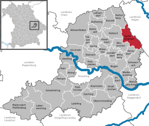
| Location of the municipality of Sankt Englmar in the Straubing-Bogen district | ||
  |
||


Sankt Englmar is a municipality in the Lower Bavarian district of Straubing-Bogen . The state-approved climatic health resort is also a well-known winter sports area .
geography
Sankt Englmar is located in the Danube Forest region in the Bavarian Forest .
Community structure
Sankt Englmar has 28 districts:
|
There is only the district Sankt Englmar.
history
Until the church is planted
According to tradition, the name of the place goes back to the hermit Engelmarus, who was born in 1060 in the Lüftlhof near Passau and, after training with the bishop, built a hermitage up the Danube. He was very popular with the population and was valued as a healer of animals. Probably because of his popularity, he was killed in the winter of 1100 by his envious “companion” and buried in the snow. It was not until Pentecost that a priest named “Ruodbertus” found the dead man, who still looked bright and fresh. He had him brought down to the valley and buried. A “stone church” was built over his grave in 1131. The valley was not settled until later and the “Ort Sankt Englmar” was created.
Engelmarus was beatified in 1188, and after the establishment of a parish in 1296, Sankt Englmar developed into a place of pilgrimage. The custom of the Englmari search on Whit Monday is maintained to this day.
A former place of summer hay is mentioned in the 19th century.
Englmar belonged to the Straubing Rent Office and to the Mitterfels Regional Court of the Electorate of Bavaria . In the course of the administrative reforms in Bavaria , today's municipality was created with the municipal edict of 1818 .
20th century
On June 1, 1959, the official name of the municipality was changed from Englmar to Sankt Englmar .
In the 1970s, the place was expanded to become a winter sports center. In November 1973, a holiday park with 440 apartments with 1150 beds and numerous hotels , shopping malls and sports facilities was opened at a height of over 900 m on an area of 52,000 m² , which the locals called “Schachterldorf”. In 1980 the community offered a capacity of 3,123 beds and 486,949 overnight stays.
Population development
In the period from 1988 to 2018, the municipality grew from 1,323 to 1,904 by 581 inhabitants or 43.9%.
- 1867: 1283 inhabitants
- 1970: 1278 inhabitants
- 1987: 1287 inhabitants
- 1991: 1426 inhabitants
- 1995: 1474 inhabitants
- 2000: 1545 inhabitants
- 2005: 1521 inhabitants
- 2010: 1514 inhabitants
- 2015: 1725 inhabitants
politics

Anton Piermeier (CSU) has been mayor since May 2008. In the 2020 election he was re-elected with 80.71%.
Culture and sights
Museums
- Getting to know natural phenomena with all your senses is the theme of the Bayerwald Xperium
Buildings

- The parish church of St. Engelmar, built in 1656 on the walls of the late Gothic choir of a previous building that had burned down, received its current tower in 1892, the nave was enlarged in 1901. In the high altar from the middle of the 17th century, the relics of St. Englmar. Under the organ gallery, six oil paintings from 1656 depict the life of the saint.
- The St. Leonhard Chapel on the southwestern edge of the village is a late Gothic building consecrated in 1480, making it the oldest building in the village. It was changed in the baroque period. The gallery and ceiling stucco date from the 18th century. Votive tablets from the 18th and 19th centuries show the former importance as a pilgrimage church.
Regular events
- The Englmarisuchen takes place on Whit Monday. The corpse of St. Englmar wanted.
- The Rauhnacht Sankt Englmar takes place annually on December 28th.
- In the winter time, qualified participants can compete in a duel on wooden skis in the strictly regulated nostalgia ski races.
Green spaces and recreation
- The Waldwipfelweg Sankt Englmar – Maibrunn, which opened on April 30, 2008, is 370 m long and leads through the treetops with several viewing platforms at a height of up to 30 m.
- In addition to the Goldsteig hiking trail, certified by the Association of German Mountain and Hiking Associations as a quality hiking trail in Germany , the Baierweg long-distance hiking trails and the Main-Danube Trail also lead through Sankt Englmar. The European long-distance hiking trail E8 and the Pandurensteig run in the immediate vicinity .
Economy and Infrastructure
education
- kindergarten
- Elementary school of the St.Englmar-Perasdorf School Association
traffic
The community is located on State Road 2139, which connects to Federal Road 85 and Federal Motorway 3 .
tourism
- Sankt Englmar toboggan and leisure paradise , a free-entry leisure park opened in 1998
- Waldwipfelweg Sankt Englmar – Maibrunn , a 370 meter long treetop path with other attractions
- Winter sports area with 13 T-bar lifts and 12 km of slopes (some with snow-making capabilities and floodlights), toboggan lift and two toboggan slopes, 105 km of cross-country ski trails and 50 km of cleared winter hiking trails
Personalities
- Josef Echinger (1841–1911), postman , mayor, member of the Reichstag and Landtag
- Walter Röhrl (* 1947), rally and racing driver, lives here
Others
On the south-western flank of the Hirschenstein near Rettenbach , BMW intended to use a 5.22-hectare area for off-road driving training, which was specially outsourced from the landscape protection area for this purpose . While environmental groups such as the Bund Naturschutz expressed concerns - among other things, a large part of the site should be sealed off - the proponents hoped for a positive effect on the region's economic development. The environmentalists prevailed.
Individual evidence
- ↑ "Data 2" sheet, Statistical Report A1200C 202041 Population of the municipalities, districts and administrative districts 1st quarter 2020 (population based on the 2011 census) ( help ).
- ↑ a b Local elections in the district of Straubing-Bogen. District Sraubing-Bogen, accessed on May 30, 2020 .
- ^ Community Sankt Englmar in the local database of the Bavarian State Library Online . Bavarian State Library
- ↑ District. Municipalities and districts. Bavarian Surveying Administration, archived from the original on April 11, 2013 ; accessed on March 31, 2015 .
- ^ Wilhelm Volkert (ed.): Handbook of Bavarian offices, communities and courts 1799–1980 . CH Beck, Munich 1983, ISBN 3-406-09669-7 , p. 437 .
- ↑ Kgl. Statistisches Bureau (Ed.): Directory of the municipalities of the Kingdom of Bavaria according to the status of the population in December 1867 . XXI. Issue of the contributions to the statistics of the Kingdom of Bavaria. Ackermann, Munich 1869, p. 52 ( digitized version ).
- ↑ Sankt Englmar in Bavaria. Retrieved November 17, 2017 .
- ↑ Primary school St.Englmar-Perasdorf in the school database of the Bavarian State Ministry for Education and Culture , accessed on August 6, 2017.
Web links
- Entry on the coat of arms of Sankt Englmar in the database of the House of Bavarian History

Aholfing | Aiterhofen | Ascha | Atting | Bow | Falkenfels | Feldkirchen | Geiselhöring | Haibach | Haselbach | Hunderdorf | Irlbach | Kirchroth | Konzell | Laberweinting | Leiblfing | Loitzendorf | Mallersdorf-Pfaffenberg | Mariaposching | Mitterfels | Neukirchen | Niederwinkling | Oberschneiding | Parkstetten | Perasdorf | Perkam | Rain | Rattenberg | Rattiszell | Salching | Sankt Englmar | Schwarzach | Stallwang | Steinach | Straßkirchen | Wiesenfelden | Windberg