
Main-Danube Way

The Main-Donau-Weg consists of four independent hiking routes that connect the two rivers Main and Danube . There is also a cross-connection between the Tauber-Wörnitz Line and the Rangau Line. The total length of all routes together is about 1158 kilometers.
Exact route information on the routes are completely recorded in OpenStreetMap on a separate page.
The Fichtelgebirgsverein , the Schwäbische Albverein , the Fränkische Albverein (FAV), the Franconian-Switzerland-Verein , the Frankenwaldverein and the Oberpfälzer Waldverein (OWV) share the care of the trails .
A continuous description of the paths including all lines can be found e.g. B. with Helmut Dumler.
mark
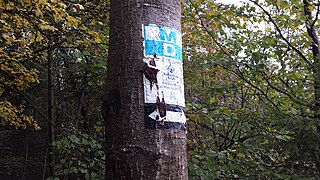
The hiking trails are marked with a white and blue MD.

Tauber-Wörnitz Line
| Tauber-Wörnitz Line | |
|---|---|
 Elevation profile |
|
| Data | |
| length | 235 km |
| location | Germany , Baden-Württemberg , Franconia |
| Starting point |
Wertheim 49 ° 44 ′ 59.8 ″ N , 9 ° 29 ′ 36.6 ″ E |
| Target point |
Donauwörth 48 ° 43 ′ 13.7 ″ N , 10 ° 46 ′ 19.5 ″ E |
| Type | Long-distance hiking trail |
The Tauber - Wörnitz line runs from Wertheim to Donauwörth and is around 235 kilometers long.
For the most part, the route coincides with the Romantic Road hiking trail from Rothenburg ob der Tauber to Nördlingen .
The Swabian Alb Association is responsible for the 95-kilometer section from Wertheim to Rothenburg ob der Tauber.
- Route
- Kreuzwertheim - Reicholzheim - Bronnbach - Gamburg - Tauberbischofsheim - Lauda-Königshofen - Bad Mergentheim - Igersheim - Weikersheim - Creglingen - Rothenburg ob der Tauber
The Franconian Albverein (FAV) is responsible for the 140-kilometer route from Rothenburg ob der Tauber to Donauwörth. The route has the number "12" in the route register of the FAV.
- Route
- Rothenburg ob der Tauber - Gebsattel - Bockenfeld - Faulenberg - Wohnbach - Schillingsfürst - Ziegelhütte - Sulz Monastery - Bortenberg - Vehlberg - Hinterbreitenthann - Vorderbreitenthann - Bronnenmühle - Glass furnace - Feuchtwangen - Herrnschallbach - Zehdorf - Köhlau - Dinkelsbühl - Oberklingenburg - - Tiefweg - Wilzenburg Bosacker - Fremdingen - Raustetten - Enslingen - Minderoffingen - Maihingen - Birkhausen - Wallerstein - Ehringen - Baldingen - Nördlingen - Nördlingen - Adlersberg - Hürnheim - Karlshof - Mönchsdeggingen - Waldschänke Eisbrunn - Bockberg - Harburg - Reismühle - Wörnitzstein - Felsheim - Donauwörth

Taubertal
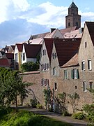
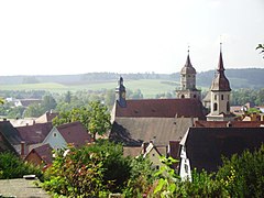
Donauwörth

In many places, like here at Dinkelsbühl , the character of the hiking trail is increasingly being changed by the installation of wind turbines. The trail markings on the left. The hiking trail then goes directly through the zone of a wind turbine that is threatened by ice shedding.
On the Feuchtwangen - Dinkelsbühl - Wilburgstetten route , the "Main-Danube-Weg" (Tauber-Wörnitz line) and Romantic Road hiking trails run parallel


.jpg)

Rangau line
| Rangau line | |
|---|---|
 Elevation profile |
|
| Data | |
| length | 277 km |
| location | Germany , Franconia , Upper Bavaria |
| Starting point |
Eltmann 49 ° 58 '13.3 " N , 10 ° 40' 3.6" E |
| Target point |
Neuburg on the Danube 48 ° 44 ′ 20.3 " N , 11 ° 10 ′ 51.9" E |
| Type | Long-distance hiking trail |
The Rangau Line runs from Eltmann to Neuburg an der Donau and is around 277 kilometers long. It leads from Mainfranken over the Steigerwald and the Aischgrund into the Altmühltal .
The Franconian-Switzerland Association is responsible for the 48-kilometer stretch from Eltmann to Höchstadt an der Aisch .
- Route
- Eltmann - Weisbrunn - Trossenfurt - Dankenfeld - Grub - Schönbrunn - Burgebrach - Dippach - Reichmannsdorf - Wachenroth - Weingartsgreuth - Höchstadt ad Aisch
The Franconian Alb Association is responsible for the 231-kilometer stretch from Höchstadt ad Aisch to Neuburg an der Donau. The route has the number 2 in the route register of the FAV.
- Route
- Höchstadt ad Aisch - Krausenbechhofen - Buch - Neuhaus - Röttenbach - Dechsendorf - Haundorf - Herzogenaurach - Burgstall - Veitsbronn - Siegelsdorf - Seckendorf - Greimersdorf - Cadolzburg - Ammerndorf - Fernabrünst - Wendsdorf - Bürglein - Bonnhof - Heilsbronn - Petersaurach - Herpersdorf - Lichtenau - Wolframs-Eschenbach - Selgenstadt - Theilenberg - Kalbensteinberg - Schnittlinger Loch - Spalt - Großweingarten - Stirn - Hohenweiler - Mandlesmühle - Pleinfeld - Lauterbrunnmühle - Ellingen - Weiboldshausen - Rohrberghaus - Gänswirthshaus - Kehl - Wülzburg - Weißenburg - Dettenheim - Schambach - Osterdorf - Pappenheim - Solnhofen - Eßlingen - Maxberg - Mörnsheim - Altendorf - Hagenacker - Dollnstein - Obereichstätt - Marienstein - Eichstätt - Moritzbrunn - Bergen - Gietlhausen - Laisacker - Bittenbrunn - Neuburg ad Donau

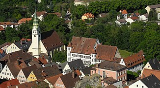
Rothenburg ob der Tauber
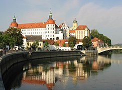
Neuburg on the Danube


Jura line
| Jurassic line | |
|---|---|
 Elevation profile |
|
| Data | |
| length | 234 km |
| location | Germany , Franconia , Upper Palatinate |
| Starting point |
Bad Staffelstein 50 ° 5 ′ 59.9 ″ N , 10 ° 59 ′ 59.2 ″ E |
| Target point |
Regensburg 49 ° 0 '31.8 " N , 12 ° 2' 21.4" E |
| Type | Long-distance hiking trail |
The 234 kilometer long Jura line begins in Bad Staffelstein and runs south through Franconian Switzerland , the Veldensteiner Forest , Hersbrucker Switzerland , the Altdorfer Land, the Upper Palatinate Jura and ends in Regensburg . Part of the hiking trail runs along the Ludwig-Danube-Main Canal .
The section from Bad Staffelstein to Neudorf is looked after by the Rennsteigverein 1896 eV local group Zapfendorf. The Franconian Switzerland Association is responsible for the Neudorf to Spies section .
- Route
- Bad Staffelstein - Burgellern - Scheßlitz - Neudorf near Scheßlitz - Oberleinleiter - Heiligenstadt - Aufseß - Wüstenstein - Tüchersfeld - Pottenstein - Bronn - Betzenstein - Spies
The Franconian Alb Association is responsible for the 107-kilometer route from Betzenstein to Beratzhausen . The route has the number "10" in the route register of the FAV.
- Route
- Spies Eibgrat - Hohe Reut - Schermshöhe - Hohenstein - Stöppach - Kleedorf - Hersbruck - Weiher - Engelthal - Steinerne Rinne am Buchenberg - Klingenhof - Hegnenberg - Altdorf, train station - Rasch - Unterölsbacher Kanal-Einschnitt - Unterölsbach - Berg - Loderbach - Labersricht - Schafhof - Wolfstein castle ruins - Höhenberg - Lengenbach - Oberbuchfeld - Harenzhofen - Lengenfeld - Velburg - Klapfenberg - Darshofen - Degerndorf - Wieselbruck - Beratzhausen
The Upper Palatinate Forest Association is responsible for the 34-kilometer route from Beratzhausen to Regensburg.
- Route

Staffelberg near Bad Staffelstein

Stone Bridge of Regensburg


East line
| East line | |
|---|---|
 Elevation profile |
|
| Data | |
| length | 326 km |
| location | Germany , Franconia , Upper Palatinate , Lower Bavaria |
| Starting point |
Bischofsgrün 50 ° 3 ′ 1.7 ″ N , 11 ° 47 ′ 43.8 ″ E |
| Target point |
Passau 48 ° 34 '33.3 " N , 13 ° 28' 21.4" E |
| Type | Long-distance hiking trail |
The east line of the Main-Danube-Weg is about 326 kilometers long and runs from Bischofsgrün to Passau . In 2014, the so-called green-white path between Armesberg and Rötz was closed . It is now continuously marked as the Main-Danube-Weg.
For the 160 km long section of Bischofsgrün to Rotz is Fichtelgebirge Club , Upper Palatinate Forest Club and Bavarian Forest Club responsible.
- Route
- Bischofsgrün - Nagel - Ebnath - Waldeck - Atzmannsberg - Hessenreuth - Parkstein - Steinfels - Dürnast - Massenricht - Kindlas - Schnaittenbach - Nabburg - Schwarzeneck - Neunburg vorm Wald - Thanstein - Rötz
The Bavarian Forest Association is responsible for the 165-kilometer section from Rötz to Passau.
- Route
- Rötz - Marketsried - Untertraubbach - Loifling - Traitsching - Sattelpeilnstein - Wies - St. Englmar - Weiherhäuser - Rusel - Lalling - Zenting - Lindau - Hundsruck - Saldenburg - Trautmannsdorf - Kalteneck - Fischhaus - Passau
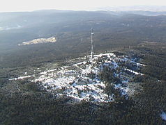
Ochsenkopf in the Fichtel Mountains

Dreiflüsse-Eck in Passau


Cross connection Feuchtwangen - Pappenheim
| Cross connection Feuchtwangen - Pappenheim | |
|---|---|
 Elevation profile |
|
| Data | |
| length | 86 km |
| location | Germany , Franconia , Upper Bavaria |
| Starting point |
Feuchtwangen 49 ° 10 ′ 4.5 ″ N , 10 ° 19 ′ 54.2 ″ E |
| Target point |
Pappenheim 48 ° 56 '4.6 " N , 10 ° 58' 30.1" E |
| Type | Long-distance hiking trail |
In addition to the 4 main routes of the Main-Danube-Weg, there is also the approximately 86 km long cross-connection between Feuchtwangen and Pappenheim .
The Franconian Alb Association is responsible for the section. The route has the number "15" in the route register of the FAV.
- Route
- Feuchtwangen - Rißmannschallbach - Oberahorn - Unterahorn - Jakobsmühle - Mittelschönbronn - Wieseth - Bruck - Waizendorf - Bechhofen - Heinersdorf - Burgstallmühle - Arberg - Goldbühl - Oberhambach - Unterhambach - Gunzenhausen - Gnotzheim - Spielberg - Heidenheim - Steinbühl - Windischhausen - Heumöderntal - Dietfurt - Treuchtfurt . Mfr. - Pappenheim
Wet cheeks
Pappenheim


Web links
Individual evidence
- ↑ As of March 2014 , measured in Openstreetmap
- ↑ Openstreetmap: Main-Donau-Weg
- ↑ Swabian Alb Association
- ^ Franconian Alb Association
- ^ Franconian Switzerland Association
- ^ Franconian Forest Association
- ↑ Upper Palatinate Forest Association
- ^ Helmut Dumler (1980), Main-Danube Paths. German hiking publisher Dr. Mair & Schnabel & Co. ISBN 3-8134-0070-0
- ^ Fränkischer Albverein, OSM hiking trails overview
HW 1: Swabian Alb North Edge Path | HW 2: Swabian Alb South Rim Trail | HW 3: Main-Neckar-Rhein-Weg | HW 4: Main-Danube-Bodensee-Weg | HW 5: Black Forest-Swabian-Alb-Allgäu-Weg | HW 6: Limes hiking trail | HW 7: Swabian-Alb-Upper Swabian Way | HW 8: Frankenweg | HW 9: Heuberg-Allgäu-Weg | HW 10: Stromberg-Swabian Forest Path | Georg-Fahrbach-Weg (GFW) | Württemberg Wine Trail (WWW) | Neckarweg | Lake Constance circular route | Main-Danube-Way | Upper Swabian Way of St. James | Franconian-Swabian Way of St. James