
Pappenheim
| coat of arms | Germany map | |
|---|---|---|

|
Coordinates: 48 ° 56 ' N , 10 ° 58' E |
|
| Basic data | ||
| State : | Bavaria | |
| Administrative region : | Middle Franconia | |
| County : | Weissenburg-Gunzenhausen | |
| Height : | 405 m above sea level NHN | |
| Area : | 64.32 km 2 | |
| Residents: | 4039 (Dec. 31, 2019) | |
| Population density : | 63 inhabitants per km 2 | |
| Postal code : | 91788 | |
| Area code : | 09143 | |
| License plate : | WUG, GUN | |
| Community key : | 09 5 77 158 | |
| City structure: | 14 districts | |
City administration address : |
Marktplatz 1 91788 Pappenheim |
|
| Website : | ||
| Mayor : | Florian Gallus ( SPD ) | |
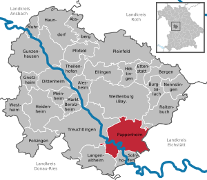
| Location of the town of Pappenheim in the Weißenburg-Gunzenhausen district | ||
  |
||

Pappenheim is a town in the central Franconian district of Weißenburg-Gunzenhausen in the Altmühltal, around 70 kilometers south of Nuremberg .
geography
Geographical location


The town of Pappenheim is located in the southeast of the Weißenburg-Gunzenhausen district in the Altmühltal in the West Central Franconia region . The Altmühl flows through the city and runs like a loop around the old town. In addition to the core city, the district ofzimmer is also on the river. The Schambach flows in the north . In addition, Pappenheim is in the Weißenburger Alb , a mountain range of the Franconian Alb . Elevations in the area of the city of Pappenheim are for example the Mühlberg (548 m), the Zimmerner Berg (548.4 m), the Fohrenbühl (568.3 m), the Zwieselberg (548.3 m) and the Zunderberg (532.6 m) m); Valleys are about the Pappenheimer Tal in the south and the Laubental in the north. The urban area is largely covered by forests. The state roads 2230 , 2387 and 2274 lead through Pappenheim . In the east Pappenheim borders on the Upper Bavarian district of Eichstätt . In the north of the urban area there are two exclaves belonging to Weißenburg .
The neighboring communities are:
| Treuchtlingen | Weißenburg in Bavaria | Raitenbuch |
| Treuchtlingen |
.svg)
|
Schernfeld |
| Langenaltheim | Langenaltheim , Solnhofen , Schernfeld | Schernfeld |
Community structure
The municipality of Pappenheim has 14 districts :
|
|
history
Until the 12th century
Traces of prehistoric settlement can be traced back to the early Neolithic on the hilltop settlement " Alte Bürg " located just to the west of the city and in the Niederpappenheim district below . Finds from the early Bronze and Hallstatt Ages also come from the “Alten Bürg” . A multi-tiered system of section walls is evidence of several phases of fortification. Another and probably more recent hilltop settlement from the late Hallstatt period existed on the "Schlossberg", on which the castle was later built. After a long break, Germanic tribes used the hill again for a fortification in the 4th or 5th century AD. It is assumed that at least in prehistoric periods there were also smaller settlements in the valley, as the Altmühl was easily passable there by a ford.
The foundation of the Pappenheim settlement can only be identified by name around 750. The earliest written mention as "Papinhaim im Sualafeld " contains a document from the year 802. Reginsind, the count's widow in Thurgau, donated assets and possessions "in and around Pappenheim" to the St. Gallen monastery . The Gallus Church , built in the 9th century, is evidence of this connection to St. Gallen and not only Pappenheim's oldest standing building, but also one of the oldest in Franconia . Above the St. Gallus Church there is another section fortification on the vineyard , which is probably a (perhaps not completed) fortification from the time of the Hungarian invasions in the 10th century, which was built to protect the St. Gall possessions could have been.
The early medieval settlement probably originated in the area around this church. Presumably at this time there was also a fortification on the "Alten Bürg", which, according to evidence of finds, lasted into the High Middle Ages . After it was destroyed, it was not rebuilt, but moved down the castle site on the spur in the Altmühlschlinge, which was in line with a general trend of the time. This Staufer castle complex was completed in 1175, as the consecration date of the castle chapel reveals. The complex was probably built as an imperial castle and initially given to the Calatine family of ministers, who now called themselves Marshals von Pappenheim , as a fiefdom , later as an allod . This family exercised its office at all imperial coronations for eight centuries.
13th to 17th centuries

As a residential city , Pappenheim became the regional center and, in addition to the many privileges of the Reichshermarschalls such as the Halsgericht and Judenregal , the city also had the right to asylum. In 1288 it was granted city rights based on the Weißenburg model. In 1634 Pappenheim was besieged by the Swedes during the Thirty Years' War , who were soon able to take the city. The castle only had to be handed over to the well room after an artillery hit. It played a brief role again in the War of the Spanish Succession in 1705 and was captured and damaged by French troops. It then fell apart and was transformed into a romantic ruin at the beginning of the 19th century, which was more in line with contemporary tastes.
The Reichsministeriales were elevated to the rank of imperial count in 1627 with Gottfried Heinrich .
Grafendörfer
In the second half of the 13th century, by order of Marshal Heinrich V. von Pappenheim, the so-called "Grafendörfer" Geislohe, Göhren, Neudorf and Osterdorf were created on the Alb plateau north of Pappenheim. They were created according to plan as clearing islands in the forest under the direction of a "Reutmeister" (clearing master ) according to a uniform scheme as street green villages : the properties are lined up on both sides of the elongated village green. Facing the field, the house with stable and outbuildings, behind it the garden and at the rear end of the property the flax crusher house - in this the flax was processed and dried. Because of the fire hazard from the drying oven, it was as far away as possible from the other buildings. The corresponding fields were lined up on this tubular plot. The Anger housed the community facilities, the " Hüll ", in which rainwater was collected, and partly also the church and cemetery. This structure can still be seen particularly well in Neudorf.
Incorporations
On April 1, 1971, the previously independent community of Übermatzhofen was incorporated into Pappenheim. On May 1, 1978, the communities of Bieswang, Geislohe, Göhren, Neudorf, Osterdorf and Zimmer were added.
saying
The name of the city is best known for the saying: “I know my Pappenheimers.” The quote goes back to Schiller's drama Wallenstein's death , in which the general Albrecht von Wallenstein says: “This is how I recognize my Pappenheimers.” He says it Appreciative to a delegation of the cuirassiers of the Gottfried Heinrich Graf zu Pappenheim regiment , who in turn asked Wallenstein beforehand whether the rumor was true that he was negotiating with the enemy Swedes behind the back of the emperor and thus practicing treason. Wallenstein does not say the famous sentence in a derogatory manner, but rather acknowledges the loyalty of the Pappenheimers because they do not believe the rumors and do not automatically turn against him, but want to hear from him for himself "what's the matter".
In the course of time the usage became blurred, the saying now has something derogatory (for example in the sense of “I know my rascals ”) or an ironic meaning. Sewer cleaners in Nuremberg have also been known as "Pappenheimer" since the late Middle Ages . This designation is due to the task of the marshals to cleanse the cities before the visit of the emperor. This task was not taken over by the Pappenheimers themselves, but by local employees, to whom the name has been transferred.
politics
City council
The distribution of the 19 seats in the city council since the local elections in 2014 is as follows:
- CSU 6 seats
- SPD 5 seats and First Mayor
- Free voters 4 seats
- Citizens' list 3 seats
Town twinning
-
 City partnership with the French community of Coussac-Bonneval
Sponsorship
-
 In 1955 a sponsorship for the expelled Sudeten Germans from the Czech city of Buchau in the former Luditz district was taken over.
Tablighi Jamaat
The local mosque in Bavaria is a center of the radical Muslim Tablighi Jamaat, along with Munich .
Culture and sights


Pappenheim is a climatic health resort and worth seeing because of the well-preserved old town. There is a hunting museum on the castle hill . There is a Buchau home parlor in the old castle.
Buildings
- Pappenheim Castle (1050)
- St. Galluskirche from the 9th century
- Romanesque " Upper Gate "
- Jewish cemetery from the 12th century
- Former Augustinian hermit monastery (founded in 1372) with the “Holy Spirit” monastery church from 1493 (the church has served exclusively as the crypt church of the marshals of Pappenheim since 1700 ), see Pappenheim monastery
- late Gothic Protestant town church St. Marien (completed in 1476)
- So-called " Old Castle ", Renaissance building from 1593
- Pappenheim Town Hall (1595)
- New Palace , built by Leo von Klenze in 1819/1820 in the classical style
- Catholic Church of the Assumption from the 19th century
- Willow Church of Protestant Youth (2007)
- Büchelehaus

City Church St. Marien, interior view


Architectural monuments

heraldry
The city coat of arms of Pappenheim shows a Moor's head with curled hair and a forehead band. The Pappenheim marshals included this figure in their crest. The head of Hieron II of Syracuse can be found on the oldest (1251) seals of the marshals . A coin with this male head from pre-Christian times served as a model. She wears a forehead band on a city seal in 1335. Due to an imprecise reproduction, the original depiction, which was taken as the emperor's head and because its colors were black on gold, turned into a Moor's head, as shown on a seal in 1378, with a tall three-pointed crown on the rather grimaceous face. It is interesting that in the 15th century - in accordance with the legend transmitted by the Brothers Grimm - a female (!) Upper body was added to this head, which in the 16th century had a plait or two protruding plaits and later became a Mohrin.
traffic
Pappenheim's station on the Ingolstadt – Treuchtlingen railway line is served by the Regional Express every hour. The public transport is carried out by the Verkehrsverbund Großraum Nürnberg (VGN).
Through the village leading state road in 2230 , the Federal Highway 2 runs about four kilometers west.
Personalities
literature
- Pleikard Joseph Stumpf : Pappenheim . In: Bavaria: a geographical-statistical-historical handbook of the kingdom; for the Bavarian people . Second part. Munich 1853, p. 748-750 ( digitized version ).
- A. von Wilke: Pappenheim . With twelve illustrations. In: Vom Fels zum Meer , 22nd year, Vol. 2, 1903, pp. 1150–1155
Web links
- Map of the urban area of Pappenheim on: BayernAtlas of the Bavarian State Government ( information )
- Official tourism website of the city of Pappenheim
- Entry on the coat of arms of Pappenheim in the database of the House of Bavarian History
- Pappenheim.info - information portal about Pappenheim
- Pappenheim: Official statistics of the LfStat
- Pappenheim from above - ANTENNA BAYERN "Bavaria from above"
Individual evidence
- ↑ "Data 2" sheet, Statistical Report A1200C 202041 Population of the municipalities, districts and administrative districts 1st quarter 2020 (population based on the 2011 census) ( help ).
- ↑ Parish Pappenheim in the local database of the Bavarian State Library Online . Bayerische Staatsbibliothek, accessed on December 25, 2019.
- ↑ M. Schußmann: A newly discovered hilltop settlement from the Hallstatt period in southern Central Franconia . In: Contributions to Archeology in Middle Franconia 3 , 1997, pp. 97-108
- ^ Pappenheim.info: History - Geislohe
- ^ Kulturwanderungen.de: To the "Pappenheimer Grafendörfern" PDF file
- ^ Town center of Neudorf. In: BayernAtlas . Retrieved May 25, 2020 .
- ^ Wilhelm Volkert (ed.): Handbook of Bavarian offices, communities and courts 1799–1980 . CH Beck, Munich 1983, ISBN 3-406-09669-7 , p. 593 .
- ^ Federal Statistical Office (ed.): Historical municipality directory for the Federal Republic of Germany. Name, border and key number changes in municipalities, counties and administrative districts from May 27, 1970 to December 31, 1982 . W. Kohlhammer, Stuttgart / Mainz 1983, ISBN 3-17-003263-1 , p. 731 .
- ↑ Hartmut Hallek: Two thousand hold the position. In: FAZ.net . June 20, 2015, accessed October 13, 2018 .
- ↑ Pappenheimer, m.. In: Jacob Grimm , Wilhelm Grimm (Hrsg.): German dictionary . tape 13 : N, O, P, Q - (VII). S. Hirzel, Leipzig 1889, Sp. 1447 ( woerterbuchnetz.de ).
- ^ City of Pappenheim: Composition of the city council. (No longer available online.) March 16, 2014, archived from the original on March 4, 2016 ; accessed on January 21, 2015 . Info: The archive link was inserted automatically and has not yet been checked. Please check the original and archive link according to the instructions and then remove this notice.
- ↑ Islamism in Bavaria - Small Towns in Fear , SZ from May 17, 2010
- ↑ P. Prusakow: Why is the Mohr in the Pappenheim coat of arms? ( Memento of the original from February 16, 2015 in the Internet Archive ) Info: The archive link was inserted automatically and has not yet been checked. Please check the original and archive link according to the instructions and then remove this notice. , Pappenheim, accessed July 6, 2015
Bieswang | Flemmühle | Geislohe | Goehren | Grafenmühle | Mittelmarterhof | Neudorf | Niederpappenheim | Ox hard | Easter Village | Paper mill | Pappenheim | Übermatzhofen | Rooms

Absberg | Alesheim | Mountains | Burgsalach | Dittenheim | Ellingen | Ettenstatt | Gnotzheim | Gunzenhausen | Haundorf | Heidenheim | Höttingen | Langenaltheim | Berolzheim market | Meinheim | Muhr am See | Nennslingen | Pappenheim | Pfofeld | Pleinfeld | Polsingen | Raitenbuch | Solnhofen | Theilenhofen | Treuchtlingen | Weißenburg in Bavaria | Westheim