
Burgsalach
| coat of arms | Germany map | |
|---|---|---|

|
Coordinates: 49 ° 2 ' N , 11 ° 6' E |
|
| Basic data | ||
| State : | Bavaria | |
| Administrative region : | Middle Franconia | |
| County : | Weissenburg-Gunzenhausen | |
| Management Community : | Nennslingen | |
| Height : | 583 m above sea level NHN | |
| Area : | 19.3 km 2 | |
| Residents: | 1156 (Dec. 31, 2019) | |
| Population density : | 60 inhabitants per km 2 | |
| Postal code : | 91790 | |
| Area code : | 09147 | |
| License plate : | WUG, GUN | |
| Community key : | 09 5 77 120 | |
| LOCODE : | DE GUV | |
| Community structure: | 3 parts of the community | |
| Association administration address: | Schmiedgasse 1 91790 Nennslingen |
|
| Website : | ||
| First Mayor : | Friedrich Amler ( village community ) | |
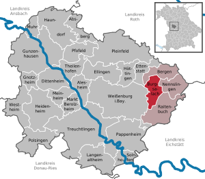
| Location of the municipality of Burgsalach in the Weißenburg-Gunzenhausen district | ||
  |
||

Burgsalach is a municipality in the central Franconian district of Weißenburg-Gunzenhausen and a member of the Nennslingen administrative community .
geography
Geographical location

The community is located in the northeast of the Weißenburg-Gunzenhausen district in the West Central Franconia region . Burgsalach is located on a plateau of the Weißenburger Alb , a partial mountain range of the Franconian Alb low mountain range , almost directly on the Limes . The Raetian Limes , the former northern border of the Roman province of Raetia , crosses the plateau. The Burgus Burgsalach , a small fort from the late Limes period, is a special building that can only be found in a similar form in North Africa . The foundation walls of this burgus, the foundations of a stone watchtower and a replica wooden watchtower bear witness to the time of Roman rule.
As one of the few bodies of water in the municipality, the Anlauter flows past in the northeast and is fed by the Aschbach in the municipality . State roads 2227 and 2228 meet in Burgsalach . To the south of Burgsalach is the Wildhau forest area , and to the north is the Büchelberg mountain .
The neighboring communities are:
| Mountains | ||
| Weißenburg in Bavaria , Ettenstatt |
.svg)
|
Nennslingen |
| Weißenburg in Bavaria | Raitenbuch |
Community structure
There are three officially named parts of the municipality (the type of place is given in brackets ):
- Burgsalach ( parish village )
- Indian book ( village )
- Pfraunfeld (parish village)
history
Until the church is planted
The Principality of Ansbach and the von Geyern taverns shared rulership rights in the village . In 1796 Prussia sequestered Geyer's rights. In the Treaty of Paris (February 1806), Burgsalach and the Principality of Ansbach, which had become Prussian in 1792, fell to the Kingdom of Bavaria through exchange, like other parts of Franconia . In the course of the administrative reforms in Bavaria, the municipality of Burgsalach was created with the municipal edict of 1818 .
Incorporations
On January 1, 1971, the municipality-free area Raitenbucher Forst was dissolved and the smaller northern part with an area of 94 hectares was incorporated into Burgsalach (the southern part came to Raitenbuch). On July 1, 1971, the previously independent community of Indernbuch was incorporated into Burgsalach. Pfraunfeld joined this voluntarily on May 1, 1978.
Parish parts
- Burgsalach (former spelling Salach )
- First mentioned at a church consecration by Bishop Gundekar II of Eichstätt in 1070. In 1281 Conrad and Hanricus von Salach handed over the patronage rights over the church of Salach to the Wülzburg monastery . In 1545 the village belongs to the von Geyern tavern. In 1551 it was called Salach near Raitenbuch . The castle was built in 1744 on the foundations of the school house. In 1913 the place received the power supply and in 1951 it was connected to the water supply.
- Indian book
- The place was probably founded in the 12th century - "in the interior of the forest", as the name suggests. Probably the first documentary mention comes from the year 1119, there the place is called Unnternpuch . At that time the church in Eichstätt received income from a farm in Indernbuch. This income was used to finance the church built in the center of the village in 1473, which was destroyed by lightning in 1674. In their place there is now a bus stop with a bell tower.
- Pfraunfeld
- The first historical data come from a Wicpert von Pfrumveld , who gave away an estate in Höbing to Berchtesgaden in 1179 . In the Thirty Years War the place was completely destroyed except for the church. Ore mining from 1693 to 1863. This floor ore was smelted in Obereichstätt. The entrance to the former ore mine can still be seen today. In the church, built in 1910 by the townspeople in the center of the village, you can see a processional pole for miners from the 18th century.
Population development
- 1961: 970 inhabitants
- 1970: 976 inhabitants
- 1987: 998 inhabitants
- 1991: 1119 inhabitants
- 1995: 1145 inhabitants
- 2000: 1178 inhabitants
- 2005: 1208 inhabitants
- 2010: 1163 inhabitants
- 2015: 1150 inhabitants
politics
Mayor and City Council
The first mayor is Friedrich Amler (village community). He was elected from Siegfried Satzinger's successor (village community) in 2002 and confirmed in office in 2008 and 2014.
There were three lists in the municipal elections in Bavaria in 2014 . The Burgsalach village community received six seats, the Pfraunfeld village community four seats and the Indernbuch free voter community two seats.
coat of arms
|
|
Blazon : “Split; in the front five times split by black and silver, in the back a silver limestorm emerging in blue with a golden roof and golden interior. " |
Architectural monuments
Soil monuments
Economy and Infrastructure
Economy including agriculture and forestry
In 1998, according to official statistics, there were 36 employees at the place of work in the manufacturing sector and 39 in trade and transport. There were a total of 383 employees at the place of residence subject to social security contributions. There were two companies in the manufacturing sector and one company in the main construction sector. In addition, in 1999 there were 57 farms with an agricultural area of 1359 hectares, of which 1027 hectares were arable land and 332 hectares were permanent green space.
traffic
In Burgsalach of the runs as a portion German Limes trail of Limes trail .
education
In 1999 the following institutions existed:
- Kindergartens: 50 kindergarten places with 44 children
- Primary school: In 2006 110 children from the community attended the school of the school association, in 2007 there were 104; closed since 2013.
telecommunications
- To the east of Indernbuch there is a 158 meter high telecommunications tower of the Deutsche Funkturm GmbH (DFMG) made of reinforced concrete (49 ° 2'42 "north latitude and 11 ° 5'14" east longitude).
Personalities
- Johann Balthasar Bernhold (1687–1769), Protestant clergyman and rector of the University of Altdorf
literature
- Johann Kaspar Bundschuh : Burgsalach . In: Geographical Statistical-Topographical Lexicon of Franconia . tape 1 : A-egg . Verlag der Stettinische Buchhandlung, Ulm 1799, DNB 790364298 , OCLC 833753073 , Sp. 510 ( digitized version ).
Web links
- Burgsalach community
- Limestower and small fort Burgsalach - Antikefan
- Burgsalach: Official statistics of the LfStat
Individual evidence
- ↑ "Data 2" sheet, Statistical Report A1200C 202041 Population of the municipalities, districts and administrative districts 1st quarter 2020 (population based on the 2011 census) ( help ).
- ↑ https://www.vg-nennslingen.de/verzeichnis/index.php?ategorie=63
- ↑ Burgsalach community in the local database of the Bavarian State Library Online . Bayerische Staatsbibliothek, accessed on December 25, 2019.
- ^ Wilhelm Volkert (ed.): Handbook of Bavarian offices, communities and courts 1799–1980 . CH Beck, Munich 1983, ISBN 3-406-09669-7 , p. 593 .
- ↑ a b c Federal Statistical Office (ed.): Historical municipality directory for the Federal Republic of Germany. Name, border and key number changes in municipalities, counties and administrative districts from May 27, 1970 to December 31, 1982 . W. Kohlhammer, Stuttgart / Mainz 1983, ISBN 3-17-003263-1 , p. 731 .
- ↑ Local elections on March 16, 2014. Allocation of seats. Burgsalach community, archived from the original on May 13, 2014 ; accessed on May 14, 2014 .
- ↑ Entry on the coat of arms of Burgsalach in the database of the House of Bavarian History

Absberg | Alesheim | Mountains | Burgsalach | Dittenheim | Ellingen | Ettenstatt | Gnotzheim | Gunzenhausen | Haundorf | Heidenheim | Höttingen | Langenaltheim | Berolzheim market | Meinheim | Muhr am See | Nennslingen | Pappenheim | Pfofeld | Pleinfeld | Polsingen | Raitenbuch | Solnhofen | Theilenhofen | Treuchtlingen | Weißenburg in Bavaria | Westheim