
Alesheim
| coat of arms | Germany map | |
|---|---|---|

|
Coordinates: 49 ° 3 ' N , 10 ° 52' E |
|
| Basic data | ||
| State : | Bavaria | |
| Administrative region : | Middle Franconia | |
| County : | Weissenburg-Gunzenhausen | |
| Management Community : | Altmuehltal | |
| Height : | 427 m above sea level NHN | |
| Area : | 20.45 km 2 | |
| Residents: | 956 (Dec. 31, 2019) | |
| Population density : | 47 inhabitants per km 2 | |
| Postal code : | 91793 | |
| Area code : | 09146 | |
| License plate : | WUG, GUN | |
| Community key : | 09 5 77 113 | |
| LOCODE : | DE AAU | |
| Community structure: | 5 districts | |
| Address of the municipal administration: |
Kirchgasse 1 91793 Alesheim |
|
| Website : | ||
| First Mayor : | Manfred Schuster, First Mayor, ( Free Association of Voters ) | |
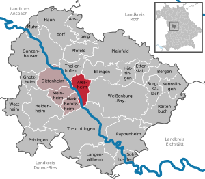
| Location of the municipality of Alesheim in the Weißenburg-Gunzenhausen district | ||
  |
||

Alesheim is a municipality in the central Franconian district of Weißenburg-Gunzenhausen with almost 1000 inhabitants and a member of the Altmühltal administrative community .
geography

.jpg)
Alesheim is located in the Altmühltal in the West Central Franconia region , eight kilometers west of the district town of Weißenburg in Bavaria . The western border of the municipality forms the Altmühl , on which Trommetsheim and Lengenfeld lie in the municipality and flow into streams such as the Störzelbach and the Lüßgraben . In the south lies the wooded Trommetsheimer Berg . The geographical center of the Weißenburg-Gunzenhausern district, which is calculated from the mean values of the four extreme coordinates of the district, is located in the municipality of Alesheim between Trommetsheim and Lengenfeld in the Heidenburg corridor.
The neighboring communities are:
| Dittenheim | Theilenhofen , Ellingen | Ellingen |
| Meinheim , market Berolzheim |
.svg)
|
Weißenburg in Bavaria |
| Treuchtlingen |
Community structure
There are 5 officially named parts of the municipality:
- Alesheim ( parish village )
- Lengenfeld ( hamlet )
- Störzelbach ( village )
- Trommetsheim (parish village)
- Wachenhofen ( Kirchdorf )
There is also the Fischerhaus residential area . There are the districts of Alesheim, Trommetsheim and Wachenhofen.
history
Until the church is planted
In 1214 the place was first mentioned as "Olofsheim" or "Olafsheim". In 1540 the church of St. Emmeram was built. Alesheim is a former office of the Deutschordenskommende Ellingen , which belonged to the Ballei Franken and was taken over by Prussia in 1796 . In the Treaty of Paris (February 1806), the village and the Prussian Principality of Ansbach were swapped to the Kingdom of Bavaria like other parts of Franconia . In the course of the administrative reforms in Bavaria, today's municipality was created with the municipal edict of 1818 .
Incorporations
On April 1, 1971, the previously independent communities Störzelbach and Wachenhofen were incorporated. Trommetsheim was added on May 1, 1978.
Population development
- 1961: 977 inhabitants
- 1970: 953 inhabitants
- 1987: 949 inhabitants
- 1991: 969 inhabitants
- 1995: 972 inhabitants
- 2000: 990 inhabitants
- 2005: 1025 inhabitants
- 2010: 991 inhabitants
- 2015: 953 inhabitants
mayor
The honorary mayor Manfred Schuster was elected for the first time in 2008, confirmed again in 2014 with 93.15 percent and in 2020 with 63.6% of the votes.
Architectural monuments
Soil monuments
Economy including agriculture and forestry
The municipal tax revenue amounted to the equivalent of 324,000 euros in 1999, of which 13,000 euros (net) was accounted for by trade tax. In 1998 there were no employees in the field of agriculture and forestry, 21 in the manufacturing sector and no employees in the field of trade and transport at the place of work. In the other economic sectors there were 22 people. There were 342 employees at the place of residence subject to social security contributions. There were none in manufacturing (as well as mining and quarrying of stones and earth), and there were four in the construction industry. In addition, in 1999 there were 74 farms with an agricultural area of 1772 hectares. Of this, 1,188 hectares were arable land and 583 hectares were permanent green space.
coat of arms
The coat of arms description reads: “Divided by gold and blue; a red spear and an obliquely left blue wave beam crossed at the top; below six three to two to one set silver iron hats. "
education
The community runs a kindergarten with 50 places. In the primary school, 127 pupils are taught by eight teachers (as of 1999).
Personalities
- Karl Dunz (born February 2, 1917 in Lengenfeld), German homeland researcher
- Antonia Katheder (* 1993 in Störzelbach), silver medalist at the 2010 Summer Youth Olympic Games
literature
- Johann Kaspar Bundschuh : Ahlesheim . In: Geographical Statistical-Topographical Lexicon of Franconia . tape 1 : A-egg . Verlag der Stettinische Buchhandlung, Ulm 1799, DNB 790364298 , OCLC 833753073 , Sp. 24 ( digitized version ).
- Gottfried Stieber: Alesheim . In: Historical and topographical news from the Principality of Brandenburg-Onolzbach . Johann Jacob Enderes, Schwabach 1761, p. 185 ( digitized version ).
Web links
- Homepage
- Alesheim: Official statistics of the LfStat
- Entry on the coat of arms of Alesheim in the database of the House of Bavarian History
Individual evidence
- ↑ "Data 2" sheet, Statistical Report A1200C 202041 Population of the municipalities, districts and administrative districts 1st quarter 2020 (population based on the 2011 census) ( help ).
- ^ Community> community council. Community of Alesheim, accessed on May 10, 2020 .
- ^ Community of Alesheim in the local database of the Bavarian State Library Online . Bayerische Staatsbibliothek, accessed on December 25, 2019.
- ^ Wilhelm Volkert (ed.): Handbook of Bavarian offices, communities and courts 1799–1980 . CH Beck, Munich 1983, ISBN 3-406-09669-7 , p. 592 .
- ↑ a b c Federal Statistical Office (ed.): Historical municipality directory for the Federal Republic of Germany. Name, border and key number changes in municipalities, counties and administrative districts from May 27, 1970 to December 31, 1982 . W. Kohlhammer, Stuttgart / Mainz 1983, ISBN 3-17-003263-1 , p. 730 .
- ↑ Results of local elections 2020. In: alesheim.de. Community of Alesheim, March 10, 2020, accessed on May 21, 2020 .

Absberg | Alesheim | Mountains | Burgsalach | Dittenheim | Ellingen | Ettenstatt | Gnotzheim | Gunzenhausen | Haundorf | Heidenheim | Höttingen | Langenaltheim | Berolzheim market | Meinheim | Muhr am See | Nennslingen | Pappenheim | Pfofeld | Pleinfeld | Polsingen | Raitenbuch | Solnhofen | Theilenhofen | Treuchtlingen | Weißenburg in Bavaria | Westheim