Gnotzheim
| coat of arms | Germany map | |
|---|---|---|

|
Coordinates: 49 ° 4 ' N , 10 ° 43' E |
|
| Basic data | ||
| State : | Bavaria | |
| Administrative region : | Middle Franconia | |
| County : | Weissenburg-Gunzenhausen | |
| Management Community : | Cockscomb | |
| Height : | 473 m above sea level NHN | |
| Area : | 12.48 km 2 | |
| Residents: | 824 (Dec. 31, 2019) | |
| Population density : | 66 inhabitants per km 2 | |
| Postal code : | 91728 | |
| Area code : | 09833 | |
| License plate : | WUG, GUN | |
| Community key : | 09 5 77 133 | |
| LOCODE : | DE GZM | |
| Market structure: | 5 parts of the community | |
Market administration address : |
Spielberger Str. 15 91728 Gnotzheim |
|
| Website : | ||
| Mayor : | Jürgen Pawlicki (independent) | |
| Location of the Gnotzheim market in the Weißenburg-Gunzenhausen district | ||

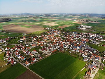
Gnotzheim is a market in the central Franconian district of Weißenburg-Gunzenhausen and a member of the administrative community Hahnenkamm based in Heidenheim .
geography
location
Gnotzheim is located in the west of the Weißenburg-Gunzenhausen district at the foot of the Hahnenkamm , a mountain range of the Franconian Alb , in the West Central Franconia region , about seven kilometers southwest of the city of Gunzenhausen . The place is at an altitude of 473 meters above sea level . In the west, the border with the Ansbach district runs . Gnotzheim is crossed by the federal highway 466 from Gunzenhausen to Nördlingen . The Wurmbach , a tributary of the Altmühl, flows through the village . The municipality is characterized by an open landscape with meadows and fields, only in the south and the extreme northeast are forest areas. The highest elevation of the community is the Spielberg , on which the district of the same name partially extends. To the west of it rises the Hagbuck with Spielberg Castle . At 12.48 square kilometers, Gnotzheim is the second smallest municipality in the Weißenburg-Gunzenhausen district.
Community structure
There are 5 officially named parts of the municipality (the type of place is given in brackets ):
- Gnotzheim (main town)
- Letzleinsmühle ( wasteland )
- Simonsmühle (wasteland)
- Spielberg ( Kirchdorf )
- Weilerau ( hamlet )
The market consists of the districts Gnotzheim and Spielberg. Some individual farms have gone, such as the Rangmühle in the 19th century and the Offenbeunder Hof .
history
Until the church is planted
Gnotzheim was first mentioned as "Gnozesheim" in a deed of donation from 1053. But the area was already settled in Roman times. "On the Weil" are the remains of the Roman cohort fort Mediana and the associated camp village. The fort was probably built around 90 AD as a wood and earth system. The expansion in stone is documented for the year 144 AD with an inscription stone. The fort was systematically researched by Heinrich Eidam in 1878. After the Romans withdrew, the Franks came , which is evidenced by row graves in the early Middle Ages . These date from the second half of the 5th century to the end of the 7th century.
From the 12th century in a document from 1122 with Pertold von Gnotzheim a noble family is handed down. After the Lords of Truhendingen ruled Gnotzheim and Spielberg in the 13th century, rule came to the Counts of Oettingen through marriage and sale in the 14th century . In 1388 Gnotzheim was granted market rights and jurisdiction. The former office of the Principality of Oettingen-Spielberg fell during border adjustments in 1796 to the Principality of Ansbach , which was taken over by Prussia in 1792 , with which it became the Kingdom of Bavaria in the Treaty of Paris in February 1806, like other parts of Franconia . In 1818 the political municipality was established.
Incorporations
On April 1, 1971, the previously independent municipality of Spielberg was incorporated.
Population development
| year | 1961 | 1970 | 1987 | 1991 | 1995 | 2000 | 2005 | 2010 | 2015 |
| Residents | 708 | 722 | 718 | 774 | 822 | 859 | 881 | 862 | 822 |
Gnotzheim is the smallest municipality in the Weißenburg-Gunzenhausen district in terms of population.
politics
The market town council consists of eight members, all of whom belong to the “ CSU / Free Citizens” list .
(Status: municipal council election on March 16, 2014 )
First mayor is Jürgen Pawlicki. This was chosen from the list.
coat of arms
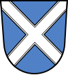
| Blazon : "A continuous silver tray in blue." | |
Economy and Infrastructure
economy
In 2014, according to official statistics, there were three in the field of agriculture, forestry and fishing, none in the manufacturing sector and 26 in the field of trade and transport at the place of work. Seven people were employed in other economic sectors subject to social security contributions. There were a total of 323 employees at the place of residence subject to social insurance contributions. There was no company in the manufacturing sector and two companies in the main construction sector. In 2010 there were also 22 farms with an agricultural area totaling 696 hectares, of which 470 hectares were arable land and 216 hectares were meadows and pastures.
education
- The kindergarten offers 39 kindergarten places (2015).
- The local elementary school is named after the Swedish writer Astrid Lindgren and has four classes with 58 students.
Attractions
- Spielberg Castle
- Catholic Parish Church of St. Michael
- Catholic Church of St. Georg , a Baroque building built between 1725 and 1727 by the builder Franz de Gabrieli from Graubünden
- Baroque John of Nepomuk monument
- Arma-Christi-Cross
Protected areas
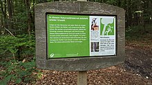
To the east of Spielberg is the 16 hectare Spielberger Leiten natural forest reserve . A stone channel has formed in the municipality south of Buckmühle . The community is located in the Ries Geopark .
Born in Gnotzheim
- Andreas Weiß (* 1954), Catholic clergyman and lawyer
literature
- Johann Kaspar Bundschuh : Gnotzheim . In: Geographical Statistical-Topographical Lexicon of Franconia . tape 6 : V-Z . Verlag der Stettinische Buchhandlung, Ulm 1804, DNB 790364328 , OCLC 833753116 , Sp. 753 ( digitized version ).
- Pleikard Joseph Stumpf : Gnotzheim . In: Bavaria: a geographical-statistical-historical handbook of the kingdom; for the Bavarian people . Second part. Munich 1853, p. 725 ( digitized version ).
Web links
Individual evidence
- ↑ "Data 2" sheet, Statistical Report A1200C 202041 Population of the municipalities, districts and administrative districts 1st quarter 2020 (population based on the 2011 census) ( help ).
- ^ Community Gnotzheim in the local database of the Bavarian State Library Online . Bayerische Staatsbibliothek, accessed on December 25, 2019.
- ^ Wilhelm Volkert (ed.): Handbook of Bavarian offices, communities and courts 1799–1980 . CH Beck, Munich 1983, ISBN 3-406-09669-7 , p. 477 .
- ↑ Municipal Council. Gnotzheim community, accessed on August 2, 2020 .
- ↑ CSU / Free Citizens
- ^ Entry on the coat of arms of Gnotzheim in the database of the House of Bavarian History
- ↑ Gnotzheim: Official statistics of the LfStat
- ^ Astrid Lindgren School
- ↑ Gnotzheim: Official statistics of the LfStat
- ↑ https://www.lwf.bayern.de/biodiversitaet/naturwaldreservate/065550/index.php
- ↑ https://www.geopark-ries.de/karte/


