Heidenheim (Middle Franconia)
| coat of arms | Germany map | |
|---|---|---|

|
Coordinates: 49 ° 1 ' N , 10 ° 45' E |
|
| Basic data | ||
| State : | Bavaria | |
| Administrative region : | Middle Franconia | |
| County : | Weissenburg-Gunzenhausen | |
| Management Community : | Cockscomb | |
| Height : | 529 m above sea level NHN | |
| Area : | 52.3 km 2 | |
| Residents: | 2564 (Dec. 31, 2019) | |
| Population density : | 49 inhabitants per km 2 | |
| Postal code : | 91719 | |
| Area code : | 09833 | |
| License plate : | WUG, GUN | |
| Community key : | 09 5 77 140 | |
| Market structure: | 20 parish parts | |
| Association administration address: | Ringstrasse 12 91719 Heidenheim, Germany |
|
| Website : | ||
| Mayoress : | Susanne Feller ( CSU / PWG ) | |
| Location of the Heidenheim market in the Weißenburg-Gunzenhausen district | ||
Heidenheim (also: Heidenheim am Hahnenkamm ) is a market in the central Franconian district of Weißenburg-Gunzenhausen and the seat of the administrative community Hahnenkamm .
geography
Geographical location
The market is located in the west of the Weißenburg-Gunzenhausen district in the West Central Franconia region and is located on the Hahnenkamm , a ridge of the Franconian Alb . Near the place is the 656.4 meter high Dürrenberg , the highest elevation in the district and the second highest in Middle Franconia. Further surveys in the area of the market town are the Rechenberg , the Heidenheimer Buck , the Rote Berg , the Efferaberg and the Hungerberg . The area is characterized by meadows and fields as well as forests. There are several sources in the area of the municipality, including the Rohrach , a tributary of the Wörnitz that flows through the Hahnenkammsee in the south of the municipality . Several state roads lead through Heidenheim . In the northeast the community borders on the Yellow Mountain , in the southeast on the Berolzheimer Wald .
The neighboring communities are:
| Gnotzheim | Dittenheim | My home |
| Westheim |

|
Berolzheim market |
| Pole singing | Treuchtlingen |
Community structure
There are 20 officially named parts of the municipality (the type of place is given in brackets ):
|
|
|
There are the districts Degersheim, Hechlingen am See , Heidenheim and Hohentrüdingen .
nature
There are six geotopes awarded by the Bavarian State Office for the Environment in the municipality .
- The former quarry northeast of Stahlmühle (577A006)
- The ravine north of Hechlingen (577A006)
- The iron sandstone outcrop east of Hohentrüdingen (577A015)
- The spring outlet seven springs southwest of Heidenheim (577Q001)
- The stone channel north of Hechlingen (577R005)
- The Steinerne Rinne northwest of Heidenheim or Käsrinne (577R018)
- The hollow stone northwest of Stahlmühle (577R019)
See also: List of geotopes in the Weißenburg-Gunzenhausen district
history
Until the 19th century
Heidenheim Monastery, founded in 752 by St. Wunibald , was the place of work of St. Walburga . Guardians were initially the Counts of Truhendingen (Altentrüdingen), later the Dukes of Bavaria , then the Burgraves of Nuremberg ( Hohenzollern ). Subsequently, the monastery and settlement passed to the Margraves of Ansbach . The monastery was dissolved in the course of the Reformation in 1537 , Heidenheim is still evangelical today. After the Thirty Years' War , the area became the new home of numerous exiles from Austria, who, as religious expellees, found opportunities to settle there and helped overcome the economic and demographic consequences of the war. Heidenheim belonged to the Principality of Ansbach , which was acquired by Prussia in 1791, and from 1500 was part of the Franconian Empire . As part of Ansbach, Heidenheim fell in the Treaty of Paris (February 1806) by exchange to the Kingdom of Bavaria . In the course of the administrative reforms in Bavaria, the municipality was created with the municipal edict of 1818 . As early as 1808, the market in Heidenheim became the seat of a regional court of the older order and was thus comparable to a today's district town. The Heidenheim district court initially belonged to the Altmühlkreis , from 1810 to the Oberdonaukreis and from 1817 to the Rezatkreis , which was renamed Middle Franconia in 1838 . In 1862 the Heidenheim and Gunzenhausen district courts were merged to form the Gunzenhausen district office (from 1939 Gunzenhausen district ). Heidenheim thus lost its status as the district capital and seat of a lower state administrative authority.
The place name was spoken 50 years ago by the local population about "Hoirna", today "Hoidna".
Incorporations
On July 1, 1972, the previously independent municipality of Degersheim was incorporated as part of the Bavarian municipal reform. On May 1, 1978, Hechlingen and Hohentrüdingen were added.
Population development
| year | 1840 | 1900 | 1925 | 1950 | 1961 | 1970 | 1987 |
| Residents | 3314 | 2808 | 2623 | 3148 | 2597 | 2404 | 2538 |
| year | 1991 | 1995 | 2000 | 2005 | 2010 | 2015 | 2017 |
| Residents | 2849 | 2978 | 2735 | 2536 | 2364 | 2607 | 2529 |
politics
Market council
The municipal council of Heidenheim consists of 14 members; the directly elected mayor also belongs to it. After the local elections on March 16, 2014 , the distribution of seats was as follows:
| list | Seats |
|---|---|
| CSU -PWG / Free Voters Heidenheimer List | 6th |
| Citizens for Citizens | 2 |
| Free voter community Hechlingen am See | 2 |
| List Degersheim / Rohrach | 1 |
| Civic bloc | 1 |
| Voting community Hohentrüdingen | 2 |
| total | 14th |
First mayor is Susanne Feller.
Community finances
In 2009, the municipal tax revenue amounted to 1,801,000 euros, of which (net) 737,000 euros were trade tax revenues.
coat of arms
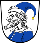
| Blazon : "Argent, a blue-clad, bearded Heide hull with blue stocking cap over silver turban." | |
Culture and sights
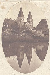
The Romanesque cathedral is a three-aisled pillar basilica from the 12th century. It was built on the foundations of an older church and has a large Gothic choir .
The modern St. Walburga church was built by the Munich architect Alexander von Branca between 1975 and 1977 on the western edge of the market on a small ridge. The church keeps elements of Heidenheim's church tradition alive. At the same time, modern people encounter central ideas of Benedictine spirituality, redesigned and in the language of a modern sacred building.
The synagogue was built by Eduard Bürklein in 1853 on the site of an older synagogue that burned down in 1851 and burned down in November 1938. The building was later used as a warehouse and demolished in the 1980s and replaced with a bank building.
Soil monuments
Economy and Infrastructure
economy
In 1998, according to official statistics, there were six in the field of agriculture and forestry, 72 in the manufacturing sector and 74 in the trade and transport sector at the place of work. In other sectors of the economy 165 people were employed subject to social security contributions. There were a total of 868 employees at the place of residence subject to social security contributions. There were none in the manufacturing sector and four in the construction sector. In 2007 there were 92 agricultural holdings with an agricultural area of at least two hectares, which farmed a total of 2329 hectares; 1438 hectares of which were arable land and 891 hectares of permanent green space.
The Hahnenkamm wind farm near Heidenheim-Degersheim, established in 1996, has consisted of twelve wind turbines since 2011.
garrison
From the 1970 Heidenheim was with the newly built Hahnenkamm barracks site of the Army of the Armed Forces . The barracks was associated with the training area a few kilometers outside of the village on a ridge, and represented a significant economic factor on the Hahnenkamm. Recently there were stationed two tank battalions and an armored engineer company. In 2003 the barracks were closed as part of the Bundeswehr reform, the tank battalions dissolved, the tanks sold to Poland and the tank pioneer company relocated to Külsheim . After the site lay fallow for a few years, a local entrepreneur bought the site and is now producing heating systems there.
education
In 2010 there were three kindergartens with a total of 150 places that were attended by 94 children. In the school year 2009/2010, 325 pupils were taught by 22 teachers in the primary school.
leisure
At the Heidenheim sports field there is a natural outdoor pool with a children's pool, a kiosk, a sunbathing lawn, a beach volleyball court and table tennis. Admission is free.
Personalities
- Wunibald (701–761), Anglo-Saxon missionary and first abbot of Heidenheim
- Walburga (around 710–779), Abbess of Heidenheim
- Hugeburc (* 730 to 740, † unknown), nun in the Heidenheim monastery, author of the saints' lives by Wunibald and Willibald von Eichstätt
- Lorenz Christoph Mizler (1711–1778), philosophical scholar and writer
- Wolf Heidenheim (1757–1832), German-Jewish scholar and printer
- Johann Heinrich Keerl (1759–1810), lawyer and writer
- Johann Christoph Henzold (1787–1858) District Court Physician
- Lazarus Bergmann (1799–1852) Scholar, rabbi and entrepreneur, son of the Heidenheim rabbi Joseph Bergmann
- Friedrich Lutz (1852–1918), brewery owner, farmer and member of the German Reichstag
- Moses Gutmann (1894–1961), doctor and allergist, 1936 emigrated to Palestine, founder of the Israeli Society for Allergology
- Waldemar Klink (1894–1979), choir director and composer
- Fritz Dietrich (* 1998), German e-athlete at Alternate Attax
literature
- Johann Kaspar Bundschuh : Heidenheim . In: Geographical Statistical-Topographical Lexicon of Franconia . tape 2 : El-H . Verlag der Stettinische Buchhandlung, Ulm 1800, DNB 790364298 , OCLC 833753081 , Sp. 543-547 ( digitized version ).
- Gottfried Stieber: Heydenheim . In: Historical and topographical news from the Principality of Brandenburg-Onolzbach . Johann Jacob Enderes, Schwabach 1761, p. 472-487 ( digitized version ).
- Pleikard Joseph Stumpf : Heidenheim . In: Bavaria: a geographical-statistical-historical handbook of the kingdom; for the Bavarian people . Second part. Munich 1853, p. 724 ( digitized version ).
Web links
- Heidenheim market
- Hechlingen am See
- Hohentrüdingen
- Heidenheim (Middle Franconia): Official statistics of the LfStat
Individual evidence
- ↑ "Data 2" sheet, Statistical Report A1200C 202041 Population of the municipalities, districts and administrative districts 1st quarter 2020 (population based on the 2011 census) ( help ).
- ↑ Heidenheim community in the local database of the Bavarian State Library Online . Bayerische Staatsbibliothek, accessed on December 25, 2019.
- ^ Gerhard Beck: Austrian exiles in the Evang.-Luth. Deanery areas Oettingen and Heidenheim. Nuremberg 2002 (sources and research on Franconian family history, 10). ISBN 3-929865-05-X .
- ^ Wilhelm Volkert (ed.): Handbook of Bavarian offices, communities and courts 1799–1980 . CH Beck, Munich 1983, ISBN 3-406-09669-7 , p. 477 .
- ^ Federal Statistical Office (ed.): Historical municipality directory for the Federal Republic of Germany. Name, border and key number changes in municipalities, counties and administrative districts from May 27, 1970 to December 31, 1982 . W. Kohlhammer, Stuttgart / Mainz 1983, ISBN 3-17-003263-1 , p. 731 .
- ^ Bavarian State Office for Statistics and Data Processing: Local elections in Bavaria on March 16, 2014. Retrieved on April 24, 2016 .
- ↑ Marktgemeinderat Heidenheim from May 2020 to April 2026. Municipality of Heidenheim (Middle Franconia), accessed on August 15, 2020 .
- ^ Entry on the coat of arms of Heidenheim (Middle Franconia) in the database of the House of Bavarian History
- ↑ Heidenheim outdoor pool (accessed on March 22, 2016)


