
Hohlweg (Hechlingen)

The ravine in Hechlingen is a canyon-like ravine near Hechlingen , a district of Central Franconia market town of Heidenheim in the district of Weissenburg-Gunzenhausen in Bavaria .
location
The ravine is located in the Altmühltal Nature Park and leads from the eastern outskirts of Hechlingen up to the Kapellenberg.
description
The Hechlinger Hohlweg is also called "Schafgasse". Over a length of around 250 meters, the path cuts up to 9 meters deep into the surrounding landscape. This makes it one of the largest and most impressive ravines in the Hahnenkamm region.
The path was created over thousands of years. Masses of water first rinsed the soil and cut into the sandstone . Cattle drive, carts and use as a footpath then created today's ravine. The path used to be one of the main routes from Hechlingen to the fields and pastures on the Kapellenberg and the Katharinenkapelle .
geology
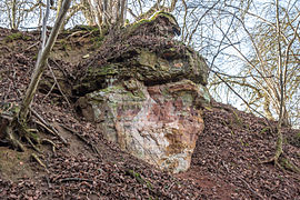
Geologically, the path offers a clearly visible outcrop of Great Dane sandstone with different ore horizons of manganese and iron ores . In its course, disturbances parallel to the slope displace the sequence of layers several times. The area is designated as a geotope (577A014) and classified as significant.
About 150 million years ago, at the time of the Malm in the Upper Jurassic , southern Germany was covered by a shallow subtropical shelf sea . A forerunner of today's Mediterranean Sea bordered this in the south. In the north there were islands and larger land masses. At the same time, rivers washed clayey material from the northern mainland into the sea. Depending on the prevalence of one or the other type of sedimentation , a characteristic alternation of different layers was created in the lower and middle Malm. The Brown Jura and the White Jura come to light in Hechlingen . In the lower and middle Malm there was a characteristic alternation of Opalinus Clay and limestone and marl stones. After that, the terrain was raised and the current landscape of the Hahnenkamm was created through erosion .
Access
The ravine is accessible for tourists with an approximately 1.8 km long local and natural history educational trail that was laid out in 2010. At the beginning and the end of the path there were two wooden gates. Some information boards accompany him up to the Katharinenkapelle.
photos

The entrance to the ravine

In the lower part
Exposure of the layers

Outcrop with vegetation


Individual evidence
- ↑ Geotope: Hohlweg near Hechlingen (accessed on January 18, 2016)
- ↑ nordbayern.de: Everything new on the "Hechlinger Hohlweg" (accessed on January 18, 2016)
- ↑ OpenStreetMap, Hechlinger Hohlweg educational trail (accessed on January 18, 2016)
Web links
Coordinates: 48 ° 58 ′ 51.8 " N , 10 ° 44 ′ 5.4" E