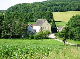
Cherry mill
|
Cherry mill
Heidenheim market
Coordinates: 49 ° 1 ′ 28 " N , 10 ° 43 ′ 44" E
|
||
|---|---|---|
| Height : | 535 m above sea level NN | |
| Residents : | 3 (Jun 30, 2011) | |
| Incorporation : | 1808 | |
| Postal code : | 91719 | |
| Area code : | 09833 | |
|
Location of Kirschenmühle in Bavaria |
||
|
Cherry mill
|
||
The cherry mill is a district of the market in Heidenheim in the central Franconian district of Weißenburg-Gunzenhausen ( Bavaria ).
location
The wasteland is in the part of the Franconian Alb called Hahenkamm in the uppermost Rohrach valley, northwest of Heidenheim and a little west of the state road 2218. Neighboring properties are Heidenheim districts in the immediate vicinity in the northeast of the Krämershof , in the northwest of the Gärtnershof and in the southwest of the one above the valley Kohlhof .
Surname
The name of the mill is interpreted as “Mühle zu Kirschenlohe;” Kirschenlohe has been the general name for the wasteland Gärtnershof , Kirschenmühle, Kohlhof , Krämershof and Obelshof since the 16th century .
history
The mill is first mentioned in a document in 1391. Heidenheim Monastery was the landlord of the mill . The mill not only had riches to give to the monastery and, after its secularization in 1537, to the Brandenburg-Ansbach monastery administrator's office in Heidenheim, but also to the Nuremberg-castlegrave , later Brandenburg-Ansbach office of Hohentrüdingen, which the bailiwick exercised over the mill. The spelling of the mill name changes to the documents and Salbüchern : Mül to Kyrsenloch (1391), Kürsche Müller (16th century) Mul to Kirschennloch (1535), mill Kirsaloch (1544), Kürschen Mühln (1616) mill Kirschenlohe ( 1682), Kirschen Mühl (1732), Kirschenmühl (1801).
In the Heidenheimer Klostersalbuch from 1400, under the heading "Kyrsenloch", it is stated: 2 farms and 1 mill. Copies of letters of inheritance for a Hans Müllner have survived for 1410, 1421 and 1447. For 1714 it is mentioned that a “cattle house” belongs to the mill with two grinding courses and one tanning course. In 1833 the cherry mill also consisted of two grinding cycles and one tanning cycle; The property included 10.6 hectares of arable land, 0.7 hectares of meadows and 5.4 hectares of forest.
At the end of the Holy Roman Empire , the mill was subject to the high court of the Prussian, formerly Margravial Oberamt Hohentrüdingen since 1792 and the former Margravial Monastery Administrator Heidenheim. Ecclesiastically it is assigned to the Protestant parish of Hechlingen.
The mill, which became royal Prussian with the Margraviate of Ansbach, became royal Bavarian as a result of the Reichsdeputationshauptschluss 1806. When tax districts were formed in 1808 , the cherry mill with other mills and wastelands came from the property of the former Heidenheim monastery to the Heidenheim tax district in the Heidenheim district court . Two years later, the tax district became the somewhat smaller rural community of Heidenheim. By the community edict of 1818, Heidenheim was again a community in the district court of the same name in 1808. In 1862 the district court of Heidenheim became part of the district office (later the district) of Gunzenhausen , which was transformed into the larger district of Weißenburg-Gunzenhausen during the regional reform in Bavaria in 1971/72.
In 1933 an accident struck the mill: the mill building burned down as the warehouse overheated. It was immediately rebuilt. The mill wheel was replaced by a turbine ; it was ground by means of two roller mills and a grist mill. In 1967 the business was deregistered and the mill continued to grind only for private use, especially grist for the mill's agriculture.
Population numbers
- 1818: 6 inhabitants
- 1824: 8 inhabitants, 1 property
- 1831: 6 inhabitants
- 1950: 16 inhabitants, 2 properties
- 1961: 8 residents, 2 residential buildings
- 1987: 5 inhabitants
- 2011: 3 residents
literature
- Joseph Anton Eisenmann and Karl Friedrich Hohn: Topo-geographical-statistical lexicon of the Kingdom of Bavaria. 1st volume. Erlangen: Joh. Jac. Palm and Ernst Enke 1831, p. 932. [1]
- Hanns Hubert Hofmann: Historical Atlas of Bavaria, Franconia Series I, Issue 8: Gunzenhausen-Weissenburg. Munich 1960.
- Official city directory for Bavaria 1964 with statistical information from the 1961 census. Munich 1964, column 785.
- Robert Schuh: Gunzenhausen. Former district of Gunzenhausen . Series of Historical Place Name Book of Bavaria. Middle Franconia, Volume 5: Gunzenhausen. Munich: Commission for bayer. Landesgeschichte 1979, especially No. 146, p. 158f.
- 1250 years Heidenheim am Hahnenkamm. Heidenheim: Historischer Verein 2002, esp. P. 100, 410f.
Web links
Individual evidence
- ↑ Schuh, p. 157f.
- ↑ 1250 years Heidenheim, pp. 104, 410
- ↑ Name information from Schuh, p. 158
- ↑ 1250 years Heidenheim, p. 38
- ↑ Historical Atlas, p. 134
- ↑ a b c d Historical Atlas, p. 235
- ↑ Historical Atlas, p. 223
- ↑ 1250 years Heidenheim, p. 100, 410f.
- ↑ Eisenmann / Hohn, p. 932
- ↑ Official Directory of places, Col. 785
- ↑ According to the Bavarian municipal parts file
- ^ Website of the Heidenheim market


