Hohentrüdingen
|
Hohentrüdingen
Heidenheim market
|
||
|---|---|---|
| Coordinates: 48 ° 59 ′ 53 ″ N , 10 ° 41 ′ 56 ″ E | ||
| Height : | 583 (501-588) m | |
| Area : | 5.98 km² | |
| Residents : | 250 (Feb 11, 2009) | |
| Population density : | 42 inhabitants / km² | |
| Incorporation : | May 1, 1978 | |
| Postal code : | 91719 | |
| Area code : | 09833 | |
|
Location of Hohentrüdingen in Bavaria |
||
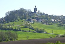
Hohentrüdingen is a district of the Heidenheim market in the Hahnenkamm administrative community in the Weissenburg-Gunzenhausen district in Middle Franconia .
location
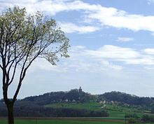
The place is located in the Hahnenkamm in the West Central Franconia region near Gunzenhausen between Heidenheim in the northeast and Westheim in the west. A connecting road to Hohentrüdingen branches off from the WUG 29 district road in a south-westerly direction, which continues to Westheim and where it joins the WUG 30 district road .
The Jakobus Pilgrimage III of the Camino de Santiago to Santiago de Compostela leads through the village on a high route . The Frankenweg , Altmühltal-Panoramaweg , Westliche Albrandweg and Fritz-Linnert-Weg lead through Hohentrüdingen . There are also several marked local hiking trails.
Hohentrüdingen is located on the 49th parallel.
Place name interpretation
The place name can be interpreted as "To the high Trüdingen;" the Lords of Trüdingen as builders of Hohentrüdingen Castle will have brought their name from Altentrüdingen at the foot of the Hesselberg. Trüdingen means "to the people of a Druhtmōd."
history
The development of the place Hohentrüdingen cannot be separated from the history of the Hohentrüdingen Castle. This was built by the Lords of Truhendingen in the 12th century. The village of Hohentrüdingen is consequently a manorial hill settlement that was cleared from the old royal forest (since 1035 episcopal-Eichstätt). The nobles of Truhendingen are mentioned for the first time in 1129 in a Eichstätter deed, the place name Hohentrüdingen appeared for the first time in 1298 with the Willingen von Hohentrüdingen. From the first half of the 15th century one learns that 9 houses, 16 Selden , 14 farmsteads, 2 estates, 2 ponds as well as a number of field goods were subject to duty to the Nuremberg castle counts office of Hohentrüdingen; The Nuremberg burgraves had finally come into Truhendingen's possession in 1404 and had probably divided the land of the building yard of Hohentrüdingen Castle among small farmers, the Seldners. In 1427 the monastery of Heidenheim came into possession in Hohentrüdingen through a judgment; it had owned wood and meadows below Hohentrüdingen since 1364 and the right to present the chaplain of the castle chapel by 1480 at the latest. In 1535 the number of Hohentrüdingen village estates, which were now subordinate to the Hohentrüdingen office of the margraves of Brandenburg, was thirty selden, two farms, a shepherd's house and a house. In 1608, five subjects of Hohentrüdingen were subordinate to the Brandenburg monastery administration office in Heidenheim, which administered the Hohentrüdingen property of the monastery which was secularized as a result of the Reformation . At the end of the Holy Roman Empire in 1800, 50 former Ansbach subjects, and since 1792 Prussian subjects, lived in Hohentrüdingen.
Hohentrüdingen, consisting of the castle, a game master's apartment, the parsonage, the school, three quarter courtyards, an inn, fifteen Selden, around thirty small estates and the community shepherd's house, came to the Kingdom of Bavaria in 1806 with the Prussian former Principality of Ansbach. In 1808 the village became part of the Hüssingen tax district in the Heidenheim district court . In 1810 Hohentrüdingen was an independent rural community to which the Kreuthof still belonged. With the parish edict of 1818, the parish lost the Kreuthof. In 1966 the community area is 597.58 hectares . The independence lasted until May 1, 1978, when the municipality was incorporated into Heidenheim as part of the regional reform in Bavaria .
Castle
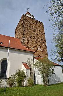
The castle Hohentrüdingen was projected on a westward built the Hahnenkamm on three sides steep mountain cone. It was considered to be the largest medieval fortification between the middle Wörnitz and Altmühl . Only the keep from the middle of the 12th century has survived; the old entrance is about nine meters high on the east side of the tower. The cuboids of the strong walls consist of Ries breccia ( Bunte Breccia ), Jura limestone and iron sandstone. The keep had been used as a church tower since the 18th century and was therefore not demolished like the rest of the castle in 1812. In the village you can still find the remains of ramparts and trenches, which suggest an extensive fortification.
Population development
- 1818: 278
- 1824: 290 inhabitants, 58 buildings
- 1867: 276 inhabitants, 109 buildings
- 1910: 285
- 1933: 244
- 1939: 227
- 1950: 331 inhabitants, 51 buildings
- 1961: 233, 46 residential buildings
- 1966: 251
- 1970: 245
- 2009: 250
Culture and sights
church
Evangelical Lutheran parish church of St. John the Baptist , simple hall church with four window axes, built in 1817/19, with the approximately 27 m high humpback keep of the former Hohentrüdinger Castle as a church tower with a polygonal tower from the 18th century and one on the south side of the Tower attached sacristy . The new building replaced the castle chapel, which was expanded for the second time from 1711 to 1720 and demolished in the early 19th century, and which the local parish, which had been parish to Westheim from time immemorial (until 1722, then its own parish), had used for worship purposes. Five-part organ case with acanthus panels from 1720. Furniture from the construction period; What is remarkable is the rectangular pulpit as a balcony over two columns, at the same time framing the sacristy door behind it. Today a new ambo-like pulpit is used on the north wall. Several aristocratic graves with coats of arms have been preserved from the 18th century. Moving the altar to the north side in 1966 resulted in a new spatial structure as a transverse hall construction.
literature
- 1250 years Heidenheim am Hahnenkamm. Heidenheim: Historical Association 2002.
- Johann Kaspar Bundschuh : Hohentrüdingen . In: Geographical Statistical-Topographical Lexicon of Franconia . tape 2 : El-H . Verlag der Stettinische Buchhandlung, Ulm 1800, DNB 790364298 , OCLC 833753081 , Sp. 741-742 ( digitized version ).
- Karl Gröber and Felix Mader (editor): The art monuments of Middle Franconia. VI. District Office Gunzenhausen. Munich: R. Oldenbourg 1937.
- Historical Atlas of Bavaria. Francs . Row I, Issue 8: Gunzenhausen-Weißenburg . Edited by Hanns Hubert Hofmann. Munich 1960.
- Hohentrüdingen. In: Georg Dehio: Handbook of German Art Monuments. Bavaria I: Franconia. 2nd, revised and supplemented edition, Munich: Deutscher Kunstverlag 1999, p. 480.
- Robert Schuh: Gunzenhausen. Former district of Gunzenhausen . Series of Historical Place Name Book of Bavaria. Middle Franconia, Vol. 5: Gunzenhausen. Munich: Commission for bayer. Landesgeschichte 1979, esp. No. 132, pp. 142–144.
- Johann Schrenk / Karl Friedrich Zink: God's houses. Church leader in the district of Weißenburg-Gunzenhausen. Treuchtlingen / Berlin: wek-Verlag 2008, p. 106f.
- Gottfried Stieber: Hohentrüdingen . In: Historical and topographical news from the Principality of Brandenburg-Onolzbach . Johann Jacob Enderes, Schwabach 1761, p. 492-497 ( digitized version ).
- Pleikard Joseph Stumpf : Hohentrüdingen . In: Bavaria: a geographical-statistical-historical handbook of the kingdom; for the Bavarian people . Second part. Munich 1853, p. 726 ( digitized version ).
- Martin Winter: Hohentrüdingen community. In: Gunzenhausen district. Munich / Assling: Publishing house for authorities and economy RA Hoeppner 1966, S. 214f.
Web links
- Entry on the coat of arms of Hohentrüdingen in the database of the House of Bavarian History
- History: Martin Winter, essays on local history [1]
- Administrative community: market town of Heidenheim [2]
- Nature conservation and landscape management: Schäferei Schmidt [3]
Individual evidence
- ↑ Schuh, pp. 143f.
- ^ Gunzenhausen district, p. 215
- ↑ 1250 years Heidenheim, p. 106
- ↑ This section mainly based on Schuh, pp. 142f.
- ↑ Historical Atlas, p. 130
- ↑ a b c d Historical Atlas, p. 235
- ↑ a b Landkreis Gunzenhausen, p. 214
- ↑ a b c Federal Statistical Office (ed.): Historical municipality directory for the Federal Republic of Germany. Name, border and key number changes in municipalities, counties and administrative districts from May 27, 1970 to December 31, 1982 . W. Kohlhammer GmbH, Stuttgart and Mainz 1983, ISBN 3-17-003263-1 , p. 731 .
- ↑ Gröber / Mader, p. 169
- ↑ Martin Winter: Essays on home history
- ↑ J. Heyberger and others: Topographical-statistical manual of the Kingdom of Bavaria together with an alphabetical local dictionary. Munich 1867, column 1038
- ↑ http://www.ulischubert.de/geografie/gem1900/gem1900.htm?mittelfranken/gunzenhausen.htm
- ^ Michael Rademacher: German administrative history from the unification of the empire in 1871 to the reunification in 1990. Gunzenhausen district. (Online material for the dissertation, Osnabrück 2006).
- ^ Official register of places for Bavaria 1964 with statistical information from the 1961 census. Munich 1964, column 785.
- ↑ Gröber / Mader, p. 166; Schrenk / Zink, p. 106
- ↑ Schrenk / Zink. P. 106f.
- ↑ Gröber / Mader, p. 167f .; Dehio, p. 480


