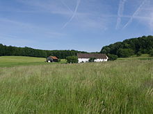
Obelshof
|
Obelshof
Heidenheim market
Coordinates: 49 ° 2 ′ 3 ″ N , 10 ° 43 ′ 16 ″ E
|
|
|---|---|
| Height : | 562 m above sea level NN |
| Residents : | 2 (Jun 30, 2011) |
| Postal code : | 91719 |
| Area code : | 09833 |
The Obelshof is a district of the Markt Heidenheim in the central Franconian district of Weißenburg-Gunzenhausen ( Bavaria ).
location
The wasteland is in the Franconian Alb northwest of Heidenheim on the district road WUG 25.
history
The settlement “Obelshof” belongs to an area that has been called “Kyrsenloch / Kirschenloh” (forest in which wild cherry trees stood) since the 11th century at the latest and consisted of several individual farms (1537: four farms: Kohlhof and three farms not named; 1732: Krämershof , Kohlhof , Gärtnershof , Kirschenmühle and Obelshof), which belonged to Heidenheim Abbey . After the secularization of the monastery, the Obelshof was, as is reported in 1616, valid and vogtable to the margravial monastery office in Heidenheim. As a result of the Thirty Years' War it was deserted in 1650, the buildings were “a little bit still”. It was then rebuilt and run by exiles from Upper Austria; In 1682 two "Obelß farmers" are named. Also in 1732 the "Obelshoff" is a double-crewed yard of the now margravial administration office of Heidenheim; the bailiwick and high Fraisch held the margravial Oberamt Hohentrüdingen at this time . This will remain so until the end of the Holy Roman Empire .
The wasteland that became royal- Prussian with the margraviate of Ansbach in 1792 became royal-Bavarian as a result of the Reichsdeputation Hauptschluss in 1806. When the tax districts were formed in 1808, the farm with other wastelands and mills, which were subject to interest from the property of the former Heidenheim monastery, was transferred to the Heidenheim district court in the Heidenheim district court . In 1810 the tax district was transformed into the somewhat smaller rural community of Heidenheim, to which the Obelshof belonged. Through the municipal edict of 1818, Heidenheim became a municipality in the district court of the same name from 1808. In 1833 the Obelshof consisted of 36.8 hectares of arable land, 5.6 hectares of meadows and 3.7 hectares of forest.
On July 1, 1862, the district court of Heidenheim became part of the district office (later the district) of Gunzenhausen , which was transformed into the larger district of Weißenburg-Gunzenhausen during the regional reform in Bavaria in 1971/72.
A dirt road leading to the east leads to a quarry, which was closed in the 1960s and where fossils (including rare ammonites ) were found. In the 19th century, an iron ore mine field extending northeast to the Obelshof was found, but it was never exploited.
Population numbers
- 1818: 3 inhabitants
- 1824: 9 inhabitants, 1 building
- 1867: 6 inhabitants, 2 buildings
- 1950: 12 inhabitants, 1 building
- 1961: 6 residents, 2 residential buildings
- 1979: 6 inhabitants
- 1987: 2 inhabitants
- June 30, 2011: 2 residents
Place name interpretation
The name of the wasteland is interpreted as “Hof eines Ōbel”, possibly as a short form of the full name “Ōtbert / Ōtbold”.
literature
- Johann Caspar Bundschuh : Geographical Statistical-Topographical Lexicon of Franconia; 4th volume, Ulm 1801, column 148.
- J. Heyberger and others: Topographical-statistical manual of the Kingdom of Bavaria with an alphabetical local dictionary. Munich 1867, column 1038.
- Hanns Hubert Hofmann: Historical Atlas of Bavaria, Franconia Series I, Issue 8: Gunzenhausen-Weissenburg. Munich 1960, p. 235.
- Official city directory for Bavaria 1964 with statistical information from the 1961 census. Munich 1964, column 785.
- Lotte Meyer-Andreae: The old stone house Obelshof near Heidenheim. Gunzenhausen: Verlag Riedel 1966.
- Robert Schuh: Gunzenhausen. Former district of Gunzenhausen . Series of Historical Place Name Book of Bavaria. Middle Franconia, Volume 5: Gunzenhausen. Munich: Commission for bayer. Landesgeschichte 1979, especially No. 192 (Obelshof), p. 201f.
- 1250 years Heidenheim am Hahnenkamm. Heidenheim: Historical Association 2002.
Individual evidence
- ↑ a b Schuh, p. 201
- ↑ 1250 years Heidenheim, pp. 261, 267
- ↑ Schuh, pp. 201f.
- ↑ Bundschuh IV, Col. 148
- ↑ a b c d Historical Atlas, p. 235
- ↑ 1250 years Heidenheim, p. 38
- ↑ Historical Atlas, p. 223
- ↑ Stuttgart Contributions to Natural History, Series B, No. 16 of July 15, 1964, see [1]
- ↑ 1250 years Heidenheim, p. 440
- ↑ Heyberger, Col. 1038
- ↑ Official Directory of places, Col. 785
- ↑ according to the Bavarian municipal parts file
- ^ Website of the Heidenheim market
- ↑ Schuh, p. 202

