Hussingen
|
Hussingen
Municipality West Home
|
|
|---|---|
| Coordinates: 48 ° 58 ′ 20 ″ N , 10 ° 41 ′ 10 ″ E | |
| Height : | 513 (490-529) m |
| Residents : | 259 (Jun 30, 2009) |
| Incorporation : | May 1, 1978 |
| Postal code : | 91747 |
| Area code : | 09082 |
|
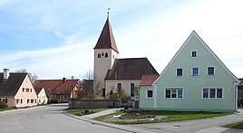
Center of Hüssingen
|
|
Hüssingen is part of the Westheim community in the Weißenburg-Gunzenhausen district in Central Franconia .
geography
The parish village is located in the Hahnenkamm , about six kilometers as the crow flies from Oettingen . To the north lies the Hüssinger Berg at a height of 554 meters above sea level . The remains of a Roman villa rustica can be found southeast of the village . To the south, the medieval desert of Hettelsberg was discovered.
State road St 2216 leads through Hüssingen, which connects the town with Steinhart and state road St 2384 near Hechlingen . The district road WUG 30 leads to Zirndorf and Unterappenberg .
history
Archaeological finds indicate that there was a settlement here as early as prehistoric times. Remains of a "villa rustica" from the 3rd century have been found from Roman times .
The place name is possibly derived from the Huosi , the name of a Bavarian noble family, who were first mentioned in 635 in the Lex Baiuvariorum . It is noticeable that there is a similar derivation possibility in the neighboring town of Hechlingen (tracing back to the noble family of the Hahilinga ). The place name ending -ingen shows that the name comes from earlier times and indicates Alemannic origins.
Already in the 12th century the place had its own church , today's Evangelical Lutheran. Filial church of St. Leonhard and Nikolaus , which belonged to the parish of Hainsfarth until 1470 and was then raised to an independent parish. During the Thirty Years War , Hüssingen was plundered several times, and the number of inhabitants decreased considerably. Between 1640 and 1660, numerous exiles from the "Ländlein ob der Enns " came to Franconia and the village, which gave the place new life.
In the Middle Ages, Hüssingen belonged to the cathedral chapter of Eichstätt , and after the Reformation it belonged to the Margraviate of Ansbach . With the community edict, Hüssingen became a political community at the beginning of the 19th century. On May 1, 1978, this was incorporated into Westheim on the occasion of the municipal reform.
Population development
Hüssingen community
- 1910: 288 inhabitants
- 1933: 266 inhabitants
- 1939: 247 inhabitants
- 1961: 254 inhabitants
- 1970: 261 inhabitants
District of Hüssingen
- 1987: 256 inhabitants
- 2009: 259 inhabitants
literature
- Johann Kaspar Bundschuh : Hüsingen . In: Geographical Statistical-Topographical Lexicon of Franconia . tape 2 : El-H . Verlag der Stettinische Buchhandlung, Ulm 1800, DNB 790364298 , OCLC 833753081 , Sp. 773 ( digitized version ).
- Gottfried Stieber: Hüsingen . In: Historical and topographical news from the Principality of Brandenburg-Onolzbach . Johann Jacob Enderes, Schwabach 1761, p. 506-507 ( digitized version ).
Web links
Individual evidence
- ^ Wilhelm Störmer: The Baiuwaren. From the Great Migration to Tassilo III ..: From the Great Migration to Tassilo III (paperback). CHBeck; Edition: 1st edition (February 20, 2002)
- ↑ Beck, Gerhard: Austrian Exulanten in the Evang.-Luth. Deanery areas Oettingen and Heidenheim . Ed .: Society for Family Research in Franconia. Self-published, Nuremberg 2002, ISBN 3-929865-05-X , p. 591 .
- ↑ a b c Federal Statistical Office (ed.): Historical municipality directory for the Federal Republic of Germany. Name, border and key number changes in municipalities, counties and administrative districts from May 27, 1970 to December 31, 1982 . W. Kohlhammer GmbH, Stuttgart and Mainz 1983, ISBN 3-17-003263-1 , p. 731 .
- ↑ Municipal directory Germany 1900 - Kingdom of Bavaria - District Middle Franconia - District Office Gunzenhausen. On: gemeindeververzeichnis.de
- ^ Michael Rademacher: German administrative history from the unification of the empire in 1871 to the reunification in 1990. Gunzenhausen district. (Online material for the dissertation, Osnabrück 2006).


