
Altmühltal Panorama Trail
| Altmühltal Panorama Trail | |
|---|---|
 Waymarks |
|
| map | |
.png)
|
|
| Data | |
| length | 201 km |
| location | Germany , Bavaria |
| Markers |

|
| Starting point |
Gunzenhausen 49 ° 6 ′ 34.5 " N , 10 ° 45 ′ 15.8" E |
| Target point |
Kelheim 48 ° 54 ′ 41.6 " N , 11 ° 52 ′ 49" E |
| Type | Long-distance hiking trail |
| The highest point | 630 m, near Degersheim |
| Lowest point | 344 m, Kelheim |
| particularities | Prädikatswanderweg |

The Altmühltal-Panoramaweg is an approximately 200 kilometer long hiking trail from Gunzenhausen to Kelheim .
description
The Altmühltal-Panoramaweg is a quality hiking trail in Bavaria . It leads from Gunzenhausen via Treuchtlingen , Eichstätt and Beilngries to Kelheim .
The route leads through the districts ( Weißenburg-Gunzenhausen , Eichstätt , Neumarkt in der Oberpfalz and Kelheim ) and the cities and communities ( Gunzenhausen , Treuchtlingen , Pappenheim , Solnhofen , Mörnsheim , Dollnstein , Eichstätt , Walting , Kipfenberg , Kinding , Beilngries , Dietfurt the Altmühl , Riedenburg , Essing and Kelheim ). In addition to the main route, there are 27 loop trails.
The path leads along the Altmühl past juniper heaths and rocky landscapes. The Twelve Apostles are a rock formation between Solnhofen and Mörnsheim. Around Solnhofen, Langenaltheim , Mörnsheim, Schernfeld and Eichstätt there are quarries of the Solnhofen limestone limestone . Animal and plant species from the Jurassic period such as specimens of the ancient bird Archeopteryx were located along the way . The path also touches the Main-Danube Canal , which later takes up the natural Altmühl near Dietfurt. The wooden bridge near Essing is considered to be the longest wooden bridge in Europe. Along the way are the remains of a Celtic ring wall, Weltenburger Enge , Pappenheim Castle , the baroque and episcopal city of Eichstätt, fossil quarries, the Limes UNESCO World Heritage Site , Prunn Castle and Weltenburg Abbey with the Danube breakthrough .
The Altmühltal-Panoramaweg was a founding member of the Top Trails of Germany association in 2009.
Main route
Gunzenhausen - Spielberg - Treuchtlingen - Dollnstein - Eichstätt - Kipfenberg - Beilngries - Riedenburg - Kelheim.
Stages
The following stage recommendation is aimed at experienced and well-trained hikers.
- Stage 1: Gunzenhausen (Stadthallensteg) - Spielberg, length: 11.3 km
- Stage 2: Spielberg - Gelber Berg - Wolfsbronn - Steinbühl - Auernheim - Freihardt - Heumöderntal - Treuchtlingen, length: 29.8 km
- Stage 3: Treuchtlingen - Dietfurt i.MFr. - Pappenheim - Solnhofen - Eßlingen - Mörnsheim - Altendorf - Dollnstein, length: 30 km
- Stage 4: Dollnstein - Obereichstätt - Blumenberg - Wintershof - Eichstätt, length: 14.2 km
- Stage 5: Eichstätt - Buchenhüll Mammoth Cave - Rieshofen - Isenbrunn - Gungolding - Arnsberg - Arnsberger Leite - Böhming - Kipfenberg, length: 29.8 km
- Stage 6: Kipfenberg - Kinding - Unteremmendorf - Kratzmühle - Pfraundorf - Badanhausen - Hirschberg - Beilngries, length: 25.3 km
- Stage 7: Beilngries - Töging - Deising - Altmühlmünster - Obereggersberg - Gundlfing - Jachenhausen - Riedenburg, length: 31.9 km
- Stage 8: Riedenburg - Nusshausen - Prunn Palace - Weihermühle - Altessing - Keltenwall - Klösterl - Kelheim, length: 22.1 km
mark

The entire route is well marked with yellow-red signs, with additional directions, signs with kilometer information and location information. Some narrow paths, especially through nature reserves, are closed to cyclists. There are mostly designated diversion routes on site.
Loop paths
- Loop path 1, Teufelsmauer-Weg: Gunzenhausen - Unterwurmbach - Gunzenhausen, length: 15 km
- Loop path 3, Hahnenkamm: Spielberg - Heidenheim - Hechlingen am See - Degersheim, length: 17 km
- Loop path 6, Altmühlblick: Treuchtlingen - Wettelsheim - Bubenheim - Graben - Treuchtlingen, length: 16 km
- Loop path 7, Reichsstadtweg: Weißenburg - Suffersheim - Geislohe - Pappenheim, length: 17 km
- Loop path 8, Pappenheim: circular route around Pappenheim, length: 8 km
- Loop path 9, Solnhofen - Mörnsheim: Solnhofen - Langenaltheim - Mörnsheim, length: 18 km
- Loop path 11, Dollnstein - Wellheim: Dollnstein - Konstein - Wellheim - Dollnstein, length: 17 km
- Loop path 12, Schernfeld: Schönfeld - Schernfeld - Rupertsbuch - Wegscheid - Obereichstätt, length: 17.5 km
- Loop path 14, Eichstätt: Eichstätt - Landershofen - Buchenhüll - Eichstätt, length: 14.8 km
- Loop path 15, Walting: Pfünz - Mammuthöhle - Buchenhüll - Walting - Pfünz, length: 18.8 km
- Loop path 16, Mühlenweg: Arnsberg - Schambach - Attenzell - Kipfenberg - Grösdorf, length: 18.4 km
- Loop path 17, knight and roman path: Erlinghofen - Erkertshofen - Titting - Emsing - Altdorf - Erlinghofen, length: 22.5 km
- Loop path 18, romantic path in the Anlautertal: Erlinghofen - Eibwang - Enkering - Erlinghofen, length: 15 km
- Loop path 19, Schwarzachtal – Panoramaweg: Greding - Heimbach - Enkering - Kinding - Greding, length: 23.5 km
- Loop path 22, Sulztal hiking path: Beilngries - Plankstetten - Berching - Beilngries, length: 22.5 km
- Loop path 23, Labertalweg: Lassoweg: Dietfurt - Unterbürg - Voglmühle - Dürn - Breitenbrunn - Dietfurt, length: 26.5 km
- Loop path 24, Schambachtal Hiking path: Riedenburg - Hattenhausen - Altmannstein - Hexenagger - Fraunberghausen - Riedenburg, length: 23 km
- Loop path 25, Riedenburg: Riedenburg - Jachenhausen - Riedenburg, length: 12.8 km
- Loop path 26, Essing – Ihrlerstein: Essing - Altessing - Schulerloch - Ihrlerstein - Kelheim, length: 12.8 km
- Loop path 27, Weltenburger Höhenweg: Kelheim - Hohenpfahl - Weltenburg - Weltenburg Abbey, length: 6.4 km
Awards
The Altmühltal-Panoramaweg was released in 2005 and one year later it was certified as a quality hiking trail with the seal of approval of the German Hiking Association .
The German hikers chose the Altmühltal-Panoramaweg as the hiking trail of the year 2007, and in 2012 it was named Germany's most beautiful hiking trail.
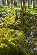
photos
Stone channel near Wolfsbronn

Arnsberger Leite rock group near Kipfenberg

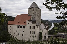
Kipfenberg Castle

Peat rocks near Unteremmerndorf
Prunn Castle

Danube breakthrough near Kelheim


Individual evidence
- ↑ http://www.wanderbaren-deutschland.de: Altmühltal-Panoramaweg (accessed on January 21, 2017)
- ↑ Award 2012 as the most beautiful hiking trail in Germany ( Memento from February 28, 2014 in the Internet Archive ) (accessed on November 22, 2019)
Web links
- Altmühltal – Panoramaweg in Openstreetmap . Course and known loops
- Homepage of the Altmühltal-Panoramaweg