
District of Eichstätt
| coat of arms | Germany map |
|---|---|

|

Coordinates: 48 ° 54 ' N , 11 ° 22' E |
| Basic data | |
| State : | Bavaria |
| Administrative region : | Upper Bavaria |
| Administrative headquarters : | Eichstatt |
| Area : | 1,214.06 km 2 |
| Residents: | 132,881 (Dec. 31, 2019) |
| Population density : | 109 inhabitants per km 2 |
| License plate : | EGG |
| Circle key : | 09 1 76 |
| NUTS : | DE219 |
| Circle structure: | 30 parishes |
| Address of the district administration: |
Residenzplatz 1 85072 Eichstätt |
| Website : | |
| District Administrator : | Alexander Anetsberger ( CSU ) |
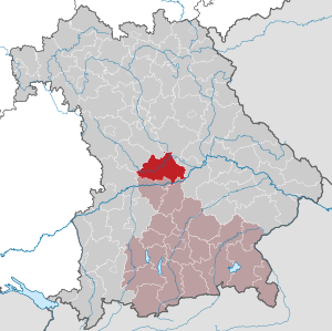
| Location of the Eichstätt district in Bavaria | |
  |
|

The Eichstätt district is the northernmost district of the Upper Bavaria administrative district and belongs to the Ingolstadt planning region .
geography
location
The area of the district of Eichstätt essentially comprises the Eichstätter Alb in the southern Franconian Alb with the core area of the Altmühltal . The Altmühl reaches the district in the west near Solnhofen , then flows through it in an easterly, later in a north-easterly direction, and leaves it again east of Beilngries . In the extreme south the Danube grazes , in the northeast the Main-Danube Canal briefly touches the district area. This makes the Eichstätt district the only one in Upper Bavaria that is mostly or almost exclusively north of the Danube. In the district is close to the market Kipfenberg the geographic center of the State of Bavaria .
Neighboring areas
The district borders clockwise in the north, starting with the districts of Roth , Neumarkt in der Oberpfalz , Kelheim and Pfaffenhofen an der Ilm , the independent city of Ingolstadt and the districts of Neuburg-Schrobenhausen , Donau-Ries and Weißenburg-Gunzenhausen .
Protected areas
There are eight nature reserves , one landscape protection area , ten FFH areas and at least 85 geotopes designated by the Bavarian State Office for the Environment in the district . (As of August 2016)
See also
- List of nature reserves in the Eichstätt district
- List of landscape protection areas in the Eichstätt district
- List of FFH areas in the Eichstätt district
- List of geotopes in the Eichstätt district
history
Regional courts
Before 1800 the area of the district of Eichstätt belonged to the Hochstift Eichstätt , the southern part belonged to Bavaria early on. In 1803 the district court of Ingolstadt was established. After the incorporation of the Hochstift Eichstätt into the Kingdom of Bavaria in 1806, the regional courts of Eichstätt and Kipfenberg were established. From 1808 all three regional courts belonged to the Altmühlkreis , whose capital was Eichstätt. In 1809 Eichstätt and Ingolstadt became urban districts . After the dissolution of the Altmühlkreis in 1810, the three regional courts belonged to the Oberdonaukreis , the capital of which was initially Eichstätt and from 1817 Augsburg . From 1817 to 1833, the Eichstätt and Kipfenberg regional courts belonged to the Principality of Eichstätt within Bavaria as rulership courts . After the reorganization in 1838, the two regional courts Eichstätt and Kipfenberg belonged to the district of Middle Franconia , the regional court of Ingolstadt to the district of Upper Bavaria .
District Offices
The Eichstätt district office was formed in 1862 through the merger of the older district courts Eichstätt and Kipfenberg. The Ingolstadt district office followed the Ingolstadt district court of the same area. The Ingolstadt district office underwent a change in 1880 when it had to hand over ten municipalities to the Neuburg adDonau district office.
Counties
On January 1, 1939, as everywhere in the German Reich, the designation district was introduced. Thus the district offices became the districts of Eichstätt and Ingolstadt. On April 1, 1940, the city of Eichstätt was incorporated into the Eichstätt district, which was reversed on April 1, 1948. On April 1, 1951, the district of Eichstätt was enlarged to include the municipality of Sornhüll in the district of Hilpoltstein .
District of Eichstätt
During the regional reform in Bavaria , the district of Eichstätt was significantly enlarged on July 1, 1972. New to the district came
- until then independent city of Eichstatt, the status of a county for the loss of freedom district town received
- the municipalities of Amtmannsdorf , Aschbuch , Beilngries, Biberbach , Eglofsdorf , Grampersdorf , Hirschberg , Kevenhüll , Kottingwörth , Litterzhofen , Oberndorf , Paulushofen and Wiesenhofen of the Upper Palatinate district of Beilngries
- the communities Altdorf , Emsing , Erkertshofen , Großnottersdorf , Kaldorf , Kesselberg , Mantlach , Morsbach , Petersbuch , Stadelhofen and Titting of the Middle Franconian district of Hilpoltstein
- the communities of Appertshofen, Demling , Eitensheim , Ettling, Gaimersheim , Großmehring , Hepberg , Kasing , Kösching , Lenting , Oberdolling , Pförring , Stammham , Theißing , Unterdolling , Wackerstein and Wettstetten in the Upper Bavarian district of Ingolstadt
- the community of Gaden near Pförring in the Upper Bavarian district of Pfaffenhofen an der Ilm and
- the communities Altmannstein , Berghausen , Bettbrunn , Forchheim, Hagenhill , Hexenagger , Hiendorf , Hüttenhausen , Laimerstadt , Lobsing , Mendorf , Mindelstetten , Neuenhinzenhausen , Pondorf , Sandersdorf , Schafshill , Schamhaupten , Steinsdorf , Tettenwang , Winden and Wolfsbuch of the Upper Palatinate district of Riedenburg .
The new district of Eichstätt was assigned to the administrative district of Upper Bavaria , to which the communities that had been added from the districts of Ingolstadt and Pfaffenhofen an der Ilm already belonged. The expiring license plate of the Altlandkreis Eichstätt used since 1956 was EIH.
On May 1, 1978, the Ensfeld community moved from the Donau-Ries district to the Eichstätt district and was incorporated into Mörnsheim .
During the COVID-19 pandemic , a provisional central test station for the entire district was set up in Eichstätt from the end of March 2020.
Population development
The district of Eichstätt gained over 25,500 inhabitants between 1988 and 2008 or grew by approx. 26%. Between 1988 and 2018 the district grew from 99,290 to 132,341 by 33,051 inhabitants or 33.3%.
The following figures refer to the territorial status on May 25, 1987.
| Population development | ||||||||||||||
|---|---|---|---|---|---|---|---|---|---|---|---|---|---|---|
| year | 1840 | 1900 | 1939 | 1950 | 1961 | 1970 | 1987 | 1991 | 1995 | 2000 | 2005 | 2010 | 2015 | |
| Residents | 49.113 | 57,539 | 62.179 | 84.045 | 77,693 | 85,585 | 97,347 | 106,438 | 112,844 | 119,561 | 123.233 | 125.015 | 128,805 | |
Economy and Infrastructure
In the Future Atlas 2016 , the Eichstätt district was ranked 26th out of 402 districts, municipal associations and independent cities in Germany, making it one of the regions with “very high future prospects”.
Economic structure
In October 2017, the unemployment rate in the Eichstätt district was 1.3%. The district thus had the lowest unemployment rate in the Federal Republic of Germany. Eichstätt also has the lowest unemployment rate of any regional authority in the European Union . For years there has been a high density of employees subject to social security contributions in the district, which means that the region has had full employment for years .
This full employment also means that the district has the lowest rate of debtors at 3.71%.
The district town of Eichstätt has had an unemployment rate in some cases below 1% or slightly above since 2008, making it the “most productive German district town”. The economic growth of the city of Eichstätt is estimated at around 7.0% and is thus well above the national average.
The economic structure is mostly from industry (Eichstätt / Ingolstadt), but also from services (in the district town of Eichstätt there are large authorities, e.g. the Catholic University of Eichstätt-Ingolstadt or the diocese of Eichstätt) as well as the focus within the five Bavarian ones Major centers (distances from Eichstätt) Munich (101 km), Nuremberg (82 km), Ansbach (78 km), Augsburg (77 km), Regensburg (98 km) and Ingolstadt (25 km). The rural areas also have enough jobs thanks to renewable energies and increasingly better rural structures.
Another important industry is tourism. The district lies in the middle of the "Altmühltal Nature Park" with the district town of Eichstätt as its center.
While Eichstätt is more of the administrative center, the communities around Ingolstadt, such as B. Gaimersheim, a higher industrial share. In addition, Beilngries, as the center of the Middle Altmühltal, is both a tourist center, but also has some metal processing companies in the city and thus represents another economic center that also has an impact on the neighboring districts of Neumarkt and Kelheim .
traffic
Street
The A 9 motorway running from Nuremberg to Ingolstadt crosses the district in a north-south direction. In the west, the federal highway 13 coming from Weißenburg leads via Eichstätt to Ingolstadt. In the east of the district the federal road 299 runs from Neumarkt via Beilngries to Neustadt an der Donau .
train
The district-free city of Ingolstadt, which is adjacent to the district, is an important railway junction. Here the north-south route Nuremberg – Treuchtlingen – Munich, opened in 1867 by the Bavarian State Railway to Ingolstadt and completed in 1870, crosses with the Regensburg –Ingolstadt– Donauwörth line, which has been in the Danube valley since 1874 .
In addition, there was the connection to Augsburg in 1875 and in 1903/04 the local railway to Riedenburg, which began in Ingolstadt's north station .
The city of Eichstätt has been connected to the Treuchtlinger Hauptbahn since 1885 by a branch line that was narrow-gauge until 1934 , which from 1898 onwards continued down the Altmühltal to Kipfenberg and in 1929/30 in Beilngries was connected to the railway that came there from Neumarkt in 1888; this was extended to Dietfurt in 1909.
From 1916 the Dollnstein – Rennertshofen branch line ran from Dollnstein in the Altmühltal on the Treuchtlingen – Ingolstadt line via Wellheim to Rennertshofen an der Donau, which was also used as a tourist railway at times.
The majority of these local railway lines - 95 km - were shut down between 1954 and 1987:
- 1954: Kipfenberg - Kinding - Beilngries 17 km
- 1960: Eichstätt town - Kipfenberg 24 km
- 1960: Dollnstein - Wellheim - Rennertshofen 11 km
- 1966: Beilngries - Kottingwörth - Dietfurt 6 km
- 1972: Ingolstadt North - Dolling - Riedenburg 35 km
- 1987: Neumarkt - Beilngries 30 km
- 2009: Neumarkt - Bögl-Werke Sengenthal 7 km
As a result, the rail network has shrunk from a length of 164 km by more than half to 69 km.
In 2006 the high-speed line Nuremberg – Ingolstadt – Munich was opened. Since then, the Munich-Nuremberg Express has been running to the Kinding (Altmühltal) stop every two hours.
Culture and sights
Stone crosses
There are numerous stone crosses in the district , most of which are also listed as architectural monuments .
politics
District administrators
- 1945 to 1948: Otto Betz
- June 1, 1948 to April 30, 1970: Hans Pappenberger
- May 1, 1970 to April 30, 1996: Konrad Regulator ( CSU )
- May 1, 1996 to April 30, 2008: Xaver Bittl (CSU)
- May 1, 2008 to April 30, 2020: Anton Knapp (CSU)
- since May 1, 2020: Alexander Anetsberger (CSU)
District council - distribution of seats
| year | CSU | SPD | FUW / FW | GREEN | ödp | FDP | left | JFW | JU | total |
| 2002 | 34 | 13 | 9 | 2 | 2 | 0 | 0 | 0 | 0 | 60 |
| 2008 | 31 | 11 | 12 | 3 | 2 | 1 | 0 | 0 | 0 | 60 |
| 2014 | 30th | 11 | 12 | 3 | 3 | 1 | 0 | 0 | 0 | 60 |
| 2020 | 24 | 8th | 11 | 6th | 2 | 1 | 1 | 3 | 4th | 60 |
Mayor of the municipalities
coat of arms
 |
Blazon : “Above the shield base with the Bavarian diamonds in gold, a red stake covered with a growing silver bishop's staff; in front a red torch on a black pipe, behind a vertical black stag pole. " |
Communities
(Residents on December 31, 2019)
|
Other communities
|
  |
Municipalities of the district before the territorial reform 1971/78
In the north, the Middle Franconian district of Eichstätt bordered the district of Hilpoltstein , in the northeast on the district of Beilngries , in the east on the district of Riedenburg , in the southeast on the district of Ingolstadt , in the south on the district of Neuburg an der Donau , in the south-west on the district of Donauwörth and in the northwest to the district of Weißenburg in Bavaria . The city of Eichstätt was independent.
Before the territorial reform in 1971/78, the Eichstätt district had 77 municipalities (see list below). Until 1951 it was one less: the municipality of Sornhüll , which was only founded in 1950, moved to the Eichstätt district in 1951. Before that, their area was part of the municipality of Altdorf in the Hilpoltstein district .
The communities of the Eichstätt district before the community reform in the 1970s (communities that still exist today are written in bold ):
License Plate
On July 1, 1956, the district was assigned the distinctive sign EIH when the vehicle registration number that is still valid today was introduced . On February 12, 1979, it was replaced by the EI, which is still valid today, as part of the regional reform .
Former letter combinations could be requested from the Federal Minister of Transport in 2013 ( license plate liberalization ). However, the district of Eichstätt did not use this for BEI , EIH and RID .
Others
In March 2014, the district was named Germany's most livable region by Focus magazine .
literature
- Gerhard Hirschmann: Eichstätt. Beilngries-Eichstätt Greding (= Historical Atlas of Bavaria, part of Franconia . I, 6). Komm. Für Bayerische Landesgeschichte, Munich 1959, DNB 452034655 ( digitized version ).
Web links
- Literature from and about the district of Eichstätt in the catalog of the German National Library
- Entry on the coat of arms of the district of Eichstätt in the database of the House of Bavarian History
Individual evidence
- ↑ "Data 2" sheet, Statistical Report A1200C 202041 Population of the municipalities, districts and administrative districts 1st quarter 2020 (population based on the 2011 census) ( help ).
- ^ Wilhelm Volkert (ed.): Handbook of Bavarian offices, communities and courts 1799–1980 . CH Beck, Munich 1983, ISBN 3-406-09669-7 , p. 455 .
- ^ Wilhelm Volkert (ed.): Handbook of Bavarian offices, communities and courts 1799–1980 . CH Beck, Munich 1983, ISBN 3-406-09669-7 , p. 97 .
- ^ Ordinance on the reorganization of Bavaria into rural districts and independent cities of December 27, 1971
- ^ Federal Statistical Office (ed.): Historical municipality directory for the Federal Republic of Germany. Name, border and key number changes in municipalities, counties and administrative districts from May 27, 1970 to December 31, 1982 . W. Kohlhammer GmbH, Stuttgart / Mainz 1983, ISBN 3-17-003263-1 , p. 599 .
- ^ "Safer than with a family doctor" , Eichstätter Kurier of March 30, 2020; Accessed April 7, 2020
- ↑ Future Atlas 2016. (No longer available online.) Archived from the original on October 2, 2017 ; accessed on March 24, 2018 . Info: The archive link was inserted automatically and has not yet been checked. Please check the original and archive link according to the instructions and then remove this notice.
- ↑ Current figures from the employment agency for the Eichstätt district
- ↑ Susanne Pfaller, Tessa Siebenhüner: Eichstätt helps unemployed Spaniards. Bayerischer Rundfunk, May 14, 2013, archived from the original on January 7, 2014 ; accessed on November 27, 2015 .
- ↑ boniversum.de: “Creditreform - Debtors' Atlas 2013”, arranged by district. Responsible for Boniversum Creditreform GmbH, Neuss, 2013. ( Memento of the original from June 10, 2015 in the Internet Archive ) Info: The archive link has been inserted automatically and has not yet been checked. Please check the original and archive link according to the instructions and then remove this notice. (accessed on November 18, 2013; PDF. 218 kB)
- ↑ Local election on March 15 , 2020 - 176 Eichstätt, district , kommunalwahl2020.bayern.de of March 17, 2020; Accessed March 19, 2020
- ↑ Overall result of the elections for the district council in the district of Eichstätt 2020 , landkreis-eichstaett.de; Accessed March 28, 2020
- ↑ Entry on the coat of arms of the district of Eichstätt in the database of the House of Bavarian History , accessed on September 5, 2017 .
- ↑ "Data 2" sheet, Statistical Report A1200C 202041 Population of the municipalities, districts and administrative districts 1st quarter 2020 (population based on the 2011 census) ( help ).
- ↑ Michael Rademacher: German administrative history from the unification of the empire in 1871 to the reunification in 1990. City and district of Eichstätt. (Online material for the dissertation, Osnabrück 2006).
- ↑ BayernViewer of the Bavarian Surveying Administration
- ↑ Eichstätt: old license plates remain outside. Donaukurier, July 12, 2013, accessed on July 7, 2019 .
- ↑ FOCUS title: District of Eichstätt is the most liveable region in Germany , Focus Online from March 16, 2014; Accessed March 17, 2014
Districts:
Aichach-Friedberg |
Altötting |
Amberg-Sulzbach |
Ansbach |
Aschaffenburg |
Augsburg |
Bad Kissingen |
Bad Toelz-Wolfratshausen |
Bamberg |
Bayreuth |
Berchtesgadener Land |
Cham |
Coburg |
Dachau |
Deggendorf |
Dillingen on the Danube |
Dingolfing-Landau |
Danube Ries |
Ebersberg |
Eichstätt |
Erding |
Erlangen-Höchstadt |
Forchheim |
Freising |
Freyung-Grafenau |
Fürstenfeldbruck |
Fürth |
Garmisch-Partenkirchen |
Gunzburg |
Hatred Mountains |
Yard |
Kelheim |
Kitzingen |
Kronach |
Kulmbach |
Landsberg am Lech |
Landshut |
Lichtenfels |
Lindau (Lake Constance) |
Main-Spessart |
Miesbach |
Miltenberg |
Mühldorf am Inn |
Munich |
Neuburg-Schrobenhausen |
Neumarkt in the Upper Palatinate |
Neustadt an der Aisch-Bad Windsheim |
Neustadt an der Waldnaab |
Neu-Ulm |
Nuremberg Country |
Oberallgäu |
Ostallgäu |
Passau |
Pfaffenhofen an der Ilm |
Rain |
Regensburg |
Rhön-Grabfeld |
Rosenheim |
Roth |
Rottal-Inn |
Schwandorf |
Schweinfurt |
Starnberg |
Straubing Arch |
Tirschenreuth |
Traunstein |
Unterallgäu |
Weilheim-Schongau |
Weißenburg-Gunzenhausen |
Wunsiedel in the Fichtel Mountains |
Wurzburg
Independent cities:
Amberg |
Ansbach |
Aschaffenburg |
Augsburg |
Bamberg |
Bayreuth |
Coburg |
Erlangen |
Fürth |
Hof (Saale) |
Ingolstadt |
Kaufbeuren |
Kempten (Allgäu) |
Landshut |
Memmingen |
Munich |
Nuremberg |
Passau |
Regensburg |
Rosenheim |
Schwabach |
Schweinfurt |
Straubing |
Willows in the Upper Palatinate |
Wurzburg