Pförring
| coat of arms | Germany map | |
|---|---|---|

|
Coordinates: 48 ° 48 ' N , 11 ° 41' E |
|
| Basic data | ||
| State : | Bavaria | |
| Administrative region : | Upper Bavaria | |
| County : | Eichstatt | |
| Management Community : | Pförring | |
| Height : | 356 m above sea level NHN | |
| Area : | 43.51 km 2 | |
| Residents: | 3849 (Dec. 31, 2019) | |
| Population density : | 88 inhabitants per km 2 | |
| Postal code : | 85104 | |
| Primaries : | 08403, 09445 | |
| License plate : | EGG | |
| Community key : | 09 1 76 153 | |
| LOCODE : | DE AQ2 | |
| Market structure: | 12 parts of the community | |
Market administration address : |
Marktplatz 1 85104 Pförring |
|
| Website : | ||
| Mayor : | Dieter Müller ( CSU ) | |
| Location of the Pförring market in the Eichstätt district | ||
Pförring is a market in the Upper Bavarian district of Eichstätt and a member of the administrative association of the same name .
geography
location
The place is in the Hallertau in the plains of the Danube floodplains , at their oxbow lakes , which are fed by the Kelsbach . The Danube flows past the place immediately south. The gently undulating hills of the beginning of the Jura extend to the north . Pförring is 25 kilometers from Ingolstadt and 95 kilometers from Munich and lies on the border with Lower Bavaria .
structure
The municipality has twelve officially named municipal parts (the type of settlement is given in brackets ):
|
Neighboring places and communities
| Mindelstetten | Altmannstein | |
| Oberdolling |

|
Neustadt an der Donau |
| Vohburg on the Danube | Münchsmünster |
history

Until the church is planted
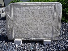
The Castrum Celeusum , one of the 80 forts that secured the Limes between the Rhine and the Danube, stood about 1.3 kilometers northeast of the current village . It was built in 141 AD and probably destroyed in the Alemannic storms in 233 AD . In "loco Faringa" the highway crossed Paris to Byzantium the Danube .
The place is said to have already been mentioned in the Nibelungenlied . In Pförring, the old Faringa or Vergen , the farm of Fergen , d. H. of the ferryman whom Hagen killed for refusing to cross the Danube with the Nibelung. The nearby marching is said to have been the Möringen mentioned in the Nibelungenlied , in which the Nibelungs finally crossed the Danube on their journey to the Hunnenland. Others consider the town of Großmehring near Ingolstadt to be the Möringen mentioned in the Nibelungenlied .
In Pförring, Charlemagne gathered his army, with which he defeated the renegade Bavarian Duke Tassilo III. defeated, and crossed the Danube here.
In later medieval times Pförring was first mentioned in a document as "Faringa" in 787 by Einhard and belonged to the Kelsgau . The name "Faringa" is used as a settlement on the "far", i. H. explained at the crossing. After being elevated to the market in 1318, the Wittelsbach family granted Pförring the privilege of building bridges over the Danube in 1367. On November 1, 1007, King Heinrich II, who was born in nearby Bad Abbach , gave his possessions in Pförring to the newly founded diocese of Bamberg . The "Bambergische Propstei Pförring" emerged from this donation . The provost office, which at times owned up to 23 properties on site, exercised landlord and judicial power in Pförring for many centuries. In 1560 the Bamberg Monastery sold its possessions to Georg von Gumppenberg.
The place belonged to the Rentamt München and to the district court Vohburg of the Electorate of Bavaria . Pförring had a market court with its own magistrate rights. In the course of the administrative reforms in Bavaria , today's municipality was created with the municipal edict of 1818 . The market belonged to the district office of Ingolstadt and later the district of Ingolstadt .
Incorporations
On April 1, 1971, the previously independent communities Ettling and Wackerstein were incorporated. On July 1, 1972, the places Gaden bei Pförring and Forchheim, Riedenburg district , were added. Lobsing followed on May 1, 1978.
Religions
The population is predominantly Roman Catholic. There are two Catholic churches and a Catholic cemetery on site. Pförring belongs to the diocese of Regensburg.
Population development
Between 1988 and 2018 the market grew from 2,783 to 4,023 by 1,240 inhabitants or 44.6%.
| year | population |
|---|---|
| 1961 | 2684 |
| 1970 | 2881 |
| 1987 | 2766 |
| 1991 | 2934 |
| 1995 | 3132 |
| 2000 | 3383 |
| 2005 | 3494 |
| 2010 | 3522 |
| 2015 | 3639 |
| 2018 | 4023 |
politics
Market council
The municipality council of Pförring has 16 members.
- CSU : 5 seats
- Independent voters e. V .: 4 seats
- Free Voters Bavaria / Young Independent Voters e. V .: 2 seats
- SPD : 1 seat
- Center Christian Union: 3 seats
- Free voters Pförring: 1 seat
The turnout was 69.86%.
(Status: local election on March 15, 2020 )
mayor
Dieter Müller ( CSU ) has been mayor since May 1, 2020 . He was elected for the first time on March 15, 2020 with 59.89% of the vote. His predecessor was Bernhard Sammiller (CSU) from March 25, 1996 to April 30, 2020.
town hall
The town hall was built between 1984 and 1987 according to plans by the Munich architect Theodor Hugues .
Culture and sights
theatre
- Theater of the Kolping family Pförring (www.theater-pfoerring.de); takes place annually
Museums
- Pförring Small House Museum
- Pförring War Museum
- Craftsman u. Pförring Farm Museum
Architectural monuments
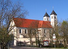
- Catholic parish church St. Leonhard
Sports
The TSV Pförring 1911 e. V. (founded November 15, 1911) has around 1,000 members. It offers tennis, badminton, unicycle, volleyball, children's gymnastics, apparatus gymnastics, gymnastics, aerobics and football for senior and junior areas. The sports halls of the school of the market in Pförring are used by the departments. The association is the organizer of the annual folk festival, which has been held since 1973. In addition to the sporting activities, many other events and trips are offered. The TSV Pförring has two large and one small court, as well as a beach volleyball court and a club house with a terrace. There are also four tennis courts with their own clubhouse and changing rooms, as well as a tool shed. Six tepee tents were procured for leisure activities, five of which have been set up. Two more small field pitches are being planned.
Regular events
- Open Air Pförring
- Georgi market
- Leonhardi ride
- Radi festival
- children Party
- Fishing festival
- Carnival parade (every two years)
Economy and Infrastructure
Economy including agriculture and forestry
The municipal tax revenue in 1999 was the equivalent of € 3,908,000, of which the equivalent of € 2,389,000 (net) was trade tax income.
According to official statistics, there were no employees subject to social security contributions at work in 1998 in the manufacturing sector 104 or in the trade and transport sector. In other economic sectors 125 people were employed at the place of work subject to social security contributions. There were a total of 1140 employees at the place of residence subject to social security contributions. There were two companies in the manufacturing sector and nine in the construction sector. In addition, in 1999 there were 118 farms with an agricultural area of 3244 hectares, of which 2921 hectares were arable land and 322 hectares were permanent green space.
Pförring is the headquarters of the electronics mail order company Pollin Electronic GmbH, one of the top 100 Internet retailers in Germany.
traffic
The place is connected to the national road network by the federal highways B299 and B16a . Lines 25 and 26 of the Ingolstädter Verkehrsgesellschaft connect the community to the greater Ingolstadt area .
education
In 1999 the following institutions existed:
- Kindergartens: 125 kindergarten places with 128 children
- Elementary schools: one with 21 teachers and 405 students
Web links
- The website of the market in Pförring
- Entry on the coat of arms of Pförring in the database of the House of Bavarian History
Individual evidence
- ↑ "Data 2" sheet, Statistical Report A1200C 202041 Population of the municipalities, districts and administrative districts 1st quarter 2020 (population based on the 2011 census) ( help ).
- ^ Parish Pförring in the local database of the Bavarian State Library Online . Bavarian State Library, accessed on September 14, 2019.
- ↑ a b c d e f Hubert Freilinger: Historical Atlas of Bavaria. Issue 46, pp. 234–237, Ed. Commission for Bavarian State History, Munich, 1977.
- ↑ Georg Rieger, Kelheimer Heimatbuch for the city and the district of Kelheim, pages 209 and 399, ed. 1953
- ^ Wilhelm Volkert (ed.): Handbook of Bavarian offices, communities and courts 1799–1980 . CH Beck, Munich 1983, ISBN 3-406-09669-7 , p. 490 .
- ^ Federal Statistical Office (ed.): Historical municipality directory for the Federal Republic of Germany. Name, border and key number changes in municipalities, counties and administrative districts from May 27, 1970 to December 31, 1982 . W. Kohlhammer, Stuttgart / Mainz 1983, ISBN 3-17-003263-1 , p. 599 .
- ↑ TOP 100 of the top-selling online shops in Germany 2017


