Praising
|
Praising
Pförring municipality
Coordinates: 48 ° 51 ′ 17 ″ N , 11 ° 41 ′ 31 ″ E
|
|
|---|---|
| Height : | 385 m above sea level NN |
| Residents : | 401 |
| Incorporation : | May 1, 1978 |
| Postal code : | 85104 |
| Area code : | 08403 |
Lobsing is a district of the municipality of Pförring in the Upper Bavarian district of Eichstätt .
Geographical location
Lobsing is located in the southern Franconian Alb on the Alb plateau at 385 m above sea level on the Dettenbach and on the state road 2232 north of the Pförring municipality.
history
Remains of a late Celtic square hill can be found southwest of the village .
A first written mention of Lobsing comes from 1109, when the Benedictine Prüfening by Bishop Otto of Bamberg received a Hofgut to Lobsing. A local nobility is proven in the 12th to 14th centuries. The residence of these gentlemen of "singing praises" has gone; it was probably located near the parish church, where in 1844 remnants of the wall (stone stairs and vaults) were found. Ulrich de Lobesingen can be traced back to 1133 as a monk of the newly built Rohr monastery , and Wilwig von Lobsing rebuilt the monastery that burned down in 1257 as abbess of Niedermünster in Regensburg .
In the Thirty Years' War Lobsing was destroyed; it was rebuilt towards the end of the 17th century. The place also suffered during the War of the Austrian Succession from 1740 to 1745, when it was looted.
From 1953 a land consolidation was carried out. Until 1968 Lobsing had its own school (it was rebuilt in 1806 on the site of the former seat of the Lords of Lobesingen); The village children attended school in Altmannstein until 1982, and since then they have been going to school in Pförring. When the Upper Palatinate district of Riedenburg was dissolved during the territorial reform in 1972 , Lobsing and its district of Pirkenbrunn became part of the former Central Franconian, now Upper Bavarian district of Eichstätt. The incorporation into the market Pförring took place on May 1, 1978. In 1983 20 full-time agricultural and 15 part-time farms were resident in the place with 220 inhabitants. There is a quarry operation.
Lobsing in the 19th century
“The place has good cultivation of fields and meadows, but the former beautiful forests are largely destroyed, hail damage is not uncommon. With a few exceptions, the population cannot be called wealthy. Imbath and Schwabstetten are the parishes after Lobsing , then the so-called villages: Tödtenacker, Hirtenhausen, Mitter- and Oberoffendorf, which have to be provided with all parish provisions by an assistant priest; the total population of the parish is only 668 souls. The parish priory has a sizeable widum with some handsome and rock-solid tithe, but the parish forest has come down very much. ”Quotation from a description by Franz Xaver Mayer, pastor in Riedenburg, from 1838.
Buildings
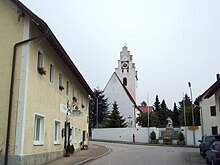
- A local church is mentioned as early as 1301. Today's Catholic parish church of St. Martin was rebuilt at the beginning of the 18th century.
- On the road to Laimerstadt there is an approximately one meter high stone atonement cross from 1594, with a leather knife and prief in relief on the front.
literature
- The Eichstätter area past and present. Sparkasse Eichstätt, Eichstätt 1984, p. 240 (there further references)
- Friedrich Hermann Hofmann, Felix Mager (editor): The art monuments of Upper Palatinate & Regensburg. XIII District Office Beilngries. II. District Court Riedenburg. Oldenbourg, Munich 1908, reprint 1982, pp. 81-83
Individual evidence
- ^ Federal Statistical Office (ed.): Historical municipality directory for the Federal Republic of Germany. Name, border and key number changes in municipalities, counties and administrative districts from May 27, 1970 to December 31, 1982 . W. Kohlhammer GmbH, Stuttgart and Mainz 1983, ISBN 3-17-003263-1 , p. 599 .
