
Eitensheim
| coat of arms | Germany map | |
|---|---|---|

|
Coordinates: 48 ° 49 ' N , 11 ° 19' E |
|
| Basic data | ||
| State : | Bavaria | |
| Administrative region : | Upper Bavaria | |
| County : | Eichstatt | |
| Management Community : | Eitensheim | |
| Height : | 403 m above sea level NHN | |
| Area : | 15.71 km 2 | |
| Residents: | 3055 (Dec. 31, 2019) | |
| Population density : | 194 inhabitants per km 2 | |
| Postal code : | 85117 | |
| Area code : | 08458 | |
| License plate : | EGG | |
| Community key : | 09 1 76 124 | |
| LOCODE : | DE EM8 | |
| Address of the municipal administration: |
Eichstätter Str. 8 85117 Eitensheim |
|
| Website : | ||
| Mayor : | Manfred Diepold (CSU) | |
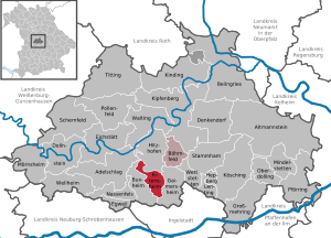
| Location of the municipality of Eitensheim in the Eichstätt district | ||
  |
||

Eitensheim is a municipality in the Upper Bavarian district of Eichstätt and the seat of the administrative association of the same name . The place of the same name is both the capital and the seat of the municipal administration.
geography
The community lies on the plateau of the southern Franconian Jura between Eichstätt and Ingolstadt in the Altmühltal nature park . There is only the Eitensheim part of the municipality .
Neighboring places and communities
| Hitzhofen | Lippertshofen (Gaimersheim) | |
| Tauberfeld (Buxheim) |
.svg)
|
Gaimersheim |
| Buxheim |
Place name interpretation
The oldest place name "Itensheim" probably means "home of the Itis", the noble, venerable woman.
history
Until the church is planted
In 1998 the grave of a man, probably a farmer, who died 7000 years ago in the Middle Neolithic , was uncovered in the “Breitenstückl” building area in Eitensheim . Relics from the ribbon ceramics found in this area are 1000 years older. Finds have also been made in the Eitensheimer Flur from the Bronze , Hallstatt and Latène Ages. In the hallway "Raitschaft" there are burial mounds , and Roman settlement could be in the Sebastian Chapel and southeast evidence of Eitensheim. An extensive villa rustica stood south of the Hessenhof .
Eitensheim, located on the Roman trading route Manching - Pfünz , was part of the basic equipment of the Eichstätter diocese, which was founded in the 8th century and endowed by the noble Suidger with the Meierhöfen of Eitensheim, Möckenlohe , Buxheim and Adelschlag as its own . First mentioned in 908 as "Itensheim" in a document from King Ludwig IV for the Eichstätter Bishop Erchanbald , the place was closely connected to the Eichstätter cathedral chapter for centuries: in 1179 the cathedral chapter was given to the cathedral chapter by Pope Alexander III. and again in 1186 by Pope Urban III. two thirds of the new fractional toe confirmed in "Itensheim". 1122 is called "Hezel et Regenhere de Itenesheim" a local nobleman as a Eichstättischer Ministeriale . On the “Mayrhoff” sat sealable, so low-nobility people, of whom from the 14./15. Century some are known by name. In 1305 the place was awarded to the Eichstätt Monastery in the dispute over the Hirschberg legacy. In 1433 28 whole and 18 half hooves as well as 2 “fire yards”, which were probably created by clearing, belonged to the cathedral chapter. In 1460 Eitensheim was plundered by Ludwig the Rich in his war against the Margrave of Ansbach and the Bishop of Eichstätt. The place was the ambulatory court seat of the office of the Eichstätter Landvogtei with its own marriage detention order from the 14th century.
At the end of the Old Kingdom the place consisted of 101 mostly rural properties. After the introduction of stable feeding in the 18th century, the number of livestock in the Principality of Eichstätt had risen sharply; In the 1790s there were 350 to 400 horned cattle in Eitensheim alone. Up to 1801, 21 farms, 2 half farms, 16 Köbler estates and 31 Selden estates paid interest to the Eichstätt court box office ; In addition, the Hofkastenamt owned 20 empty houses . The cathedral chapter Eichstätt had to pay 1 yard and 4 Seldengüter dues; 1 house was empty. The Eichstätter Heilig-Geist-Spital had 2 courtyards. Eitensheim also had the church, the rectory, the Frühmeßhaus, the schoolhouse, the servant house, the common smithy, the bathhouse and the shepherd's house.
With the Hochstift Eichstätt Eitensheim came to the Grand Duke Ferdinand of Tuscany in 1802 . In the new Kingdom of Bavaria (1806) , 546 people lived in the parish village of Eitensheim, which formed its own tax district in 1808/10 and was assigned to the Eichstätt district court. In the district court and rent office Ingolstadt since 1817, in 1818 the tax district became an independent rural community with 124 families.
19th and 20th centuries
Eitensheim, on the Ingolstadt- Treuchtlingen railway line , has had a train stop since 1889 .
1913 and 1923/24 one in 1297 was hectares comprehensive land consolidation carried out - the first in Upper Bavaria ; a stone monument, probably erected in 1924, with a figure of a boy with grain sheaves commemorates them. In 1954 a central water supply was installed; In 1971 the town was drained. In 1969 a new school with a gym was built, which from 1973 was run as elementary and partial secondary school I.
District affiliation
Eitensheim belonged to the district of Ingolstadt until the regional reform in 1972 . At that time, the district of Ingolstadt was dissolved and the communities were distributed to the districts of Eichstätt or Pfaffenhofen an der Ilm or declared a district of Ingolstadt . Eitensheim has therefore been part of the Eichstätt district since 1972 .
Population development
Between 1988 and 2018, the municipality grew from 1,822 to 3,028 by 1,206 inhabitants or 66.2% - the highest percentage increase in the district in the period mentioned.
|
|
|
|
|
|
* 2004: June 30th, otherwise December 31st
politics
Municipal council
The town council of Eitensheim has 16 members.
- CSU 8 seats
- SPD 4 seats
- Free voters Bavaria 4 seats
mayor
The mayors since 1876:
- 1876–1895: Willibald Dier
- 1895–1905: Sebastian Trini
- 1905–1924: Anton Wagner
- 1924–1933: Josef Knörr
- 1933–1946: Andreas Bauer
- 1946–1948: Ludwig Bernecker
- 1948–1966: Andreas Meyer
- 1966–1978: Franz Bernecker
- 1978–1990: Günter Lachnit
- 1990–2002: Josef Funk (SPD)
- 2002–2020: Michael Stampfer (CSU)
- since 2020: Manfred Diepold (CSU)
coat of arms
Blazon : Under a silver shield head, inside a blue St. Andrew's cross , in red a striding golden lion.
Der Löwe ist aus dem Wappen des Eichstätter Domkapitels übernommen. Das Andreaskreuz im Schildhaupt erinnert an den Kirchenpatron Sankt Andreas. Die Gemeinde nahm mit Beschluss des Gemeinderates vom 8. Februar 1983 nebenstehendes Wappen an (Wappenentwurf: Theodor Goerge). Die Regierung von Oberbayern stimmte der Annahme des Wappens am 10. Juni 1983 zu.
Culture and sights


Churches
- Catholic parish church St. Andreas : Between 1182 and 1196 a church was consecrated in "Itensheim" by the Eichstätter Bishop Otto in Eitensheim. In 1499 a major structural change was made, as an indulgence was granted . In 1742 Franz Xaver Horneis stuccoed the ceiling. This church was demolished in 1859 and replaced by a neo-Gothic building in 1859/60 , which was consecrated in 1867. An extension in the west and a complete redesign of the nave resulted in today's sacred building according to plans by Ingolstadt architect Ludwig Geith. He has older pieces of equipment. The church tower, which was damaged after a barn fire in the neighboring Meierhof on December 8, 1959, was rebuilt and is also called "God's Pencil" because of its slim design with a pointed helmet.
- Catholic St. Salvator Chapel : The present cemetery chapel , which was rebuilt in 1589/90, is a steep roof building with an onion dome roof turret attached in 1708 . The former pilgrimage chapel contains a miracle painting that refers to a pilgrimage in connection with a sacrilege . The original ceiling and wall painting is whitewashed.
- Catholic St. Sebastian Chapel: The field chapel east of Eitensheim and south of the road to Gaimersheim is a steep-roofed building with a two-tower roof turret, which was built in 1713. It contains a wooden sculpture of the Coronation of Mary from the 2nd half of the 16th century. Due to a severe storm on July 7, 2015, the chapel was severely damaged by a fallen willow tree and had to be renovated.
- Field Chapel St. Magdalena , built in 1865.
- The legendary land monument "Three Crosses" , mentioned in 1602 and recorded in a map in 1722 and standing near Bundesstraße 13, still contains traces of a Pankratius pilgrimage chapel . There is also the obelisk-like boundary stone No. 184 from 1818 between Bavaria and the Principality of Eichstätt (and until 1972 between the districts of Eichstätt and Ingolstadt).
Museums
- Eitensheim local history museum
music
- Men's choir
- church choir
Sports
- SV Eitensheim (7 departments: football, tennis, table tennis, volleyball, gymnastics, ju-jutsu, bowling)
- Schützomania Eitensheim (Carnival Guard)
- Shooting club "Orient" Eitensheim
Regular events
- March: Strong beer festival
- July: Bonfires (parish youth Eitensheim), Village Festival (Young Union Eitensheim)
- August: Delacher Festival
- November: Hoagarten, Christmas market
- December: Advent singing
traffic
-
B 13
- three exits:
- Eitensheim-North
- Eitensheim-Mitte
- Eitensheim-Süd
- three exits:
- BAB 9 (accessible from exit 60 Lenting)
- Ingolstadt – Treuchtlingen railway line with Eitensheim station
literature
- Andreas Hirsch: Eitensheim . Edited by the municipality of Eitensheim. Eitensheim 2000.
- Gerhard Hirschmann: Historical Atlas of Bavaria. Part of Franconia. Row I, Issue 6. Eichstätt. Beilngries-Eichstätt-Greding. Munich 1959.
- Hubert Freilinger: Historical Atlas of Bavaria. Part of old Bavaria. Ingolstadt . Munich 1977.
- The Eichstätter area past and present. 2nd expanded edition, Eichstätt 1984.
Web links
Individual evidence
- ↑ "Data 2" sheet, Statistical Report A1200C 202041 Population of the municipalities, districts and administrative districts 1st quarter 2020 (population based on the 2011 census) ( help ).
- ↑ Mayor. Congregation, accessed June 14, 2020 .
- ^ Community Eitensheim in the local database of the Bavarian State Library Online . Bavarian State Library, accessed on September 14, 2019.
- ↑ Hirsch, p. 7
- ↑ Eichstätter Kurier from 21./22. May 1998; Hirsch, p. 231
- ↑ Eichstätter Raum, p. 188
- ↑ Hirschmann, pp. 19 f., 62
- ↑ Hirsch, p. 74 f.
- ↑ Collective sheet Historischer Verein Eichstätt 92/93 (1999/2000), p. 290
- ↑ Hirsch, p. 78
- ↑ Eichstätter Raum, p. 187
- ↑ Hirschmann, p. 50; Hirsch, pp. 90, 106 ff.
- ↑ Hirschman, p. 61
- ↑ Hirschmann, p. 101
- ↑ Hirsch, p. 158; Freilinger, p. 323
- ↑ Freilinger, p. 311 f.
- ↑ Freilinger, p. 310
- ↑ Hirschmann, pp. 172, 201; Hirsch, p. 160
- ↑ Hirsch, p. 201
- ↑ Eichstätter Kurier of August 7, 2003
- ↑ Eichstätter Raum, p. 187, Hirsch, p. 227 ff.
- ^ Entry on the coat of arms of Eitensheim in the database of the House of Bavarian History
- ^ Church newspaper for the diocese of Eichstätt from March 20, 2011; Eichstätter Kurier from June 18, 1998 and December 15, 2009
- ↑ Hirsch, p. 103 f.
- ↑ Eichstätter Kurier of May 13, 1997
- ↑ Eichstätter Raum, p. 187; Hirsch, p. 137 f.
- ↑ Eichstätter Raum, p. 187
- ↑ Information board of the home, warrior and soldier association Tauberfeld at the "Three Crosses"; Hirsch, pp. 189-193

Adelschlag | Altmannstein | Beilngries | Böhmfeld | Buxheim | Denkendorf | Dollnstein | Egweil | Eichstätt | Eitensheim | Gaimersheim | Großmehring | Hepberg | Hitzhofen | Kinding | Kipfenberg | Koesching | Lenting | Mindelstetten | Mörnsheim | Nassenfels | Oberdolling | Pförring | Pollen field | Schernfeld | Stammham | Titting | Walting | Wellheim | Wettstetten
Non-parish areas in the Eichstätt
Haunstetter Forst district