
Treuchtlingen
| coat of arms | Germany map | |
|---|---|---|

|
Coordinates: 48 ° 57 ' N , 10 ° 55' E |
|
| Basic data | ||
| State : | Bavaria | |
| Administrative region : | Middle Franconia | |
| County : | Weissenburg-Gunzenhausen | |
| Height : | 412 m above sea level NHN | |
| Area : | 103.42 km 2 | |
| Residents: | 12,952 (Dec. 31, 2019) | |
| Population density : | 125 inhabitants per km 2 | |
| Postal code : | 91757 | |
| Area code : | 09142 | |
| License plate : | WUG, GUN | |
| Community key : | 09 5 77 173 | |
| City structure: | 54 parts of the community | |
City administration address : |
Hauptstrasse 31 91757 Treuchtlingen |
|
| Website : | ||
| Mayoress : | Kristina Becker ( CSU ) | |
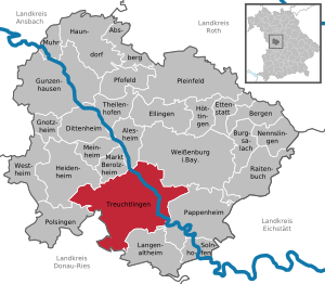
| Location of the city of Treuchtlingen in the Weißenburg-Gunzenhausen district | ||
  |
||

Treuchtlingen is a town with around 13,100 inhabitants in the southern part of the central Franconian district of Weißenburg-Gunzenhausen . Treuchtlingen is known for the Treuchtlingen marble . The railway town was once the central express train crossroads in Bavaria.
geography
Geographical location
Treuchtlingen is located in the south of the Weißenburg-Gunzenhausen district in the West Central Franconia region in the Altmühltal Nature Park at the southern end of the Hahnenkamm , a mountain range of the Franconian Alb , and is traversed by the Altmühl , which forms a valley floodplain to the south . It is a state-approved resort with a mineral spring spa ( Altmühltherme ). In the East the lead federal highway 2 over. In the southwest near Auernheim are the foothills of the Monheimer Alb , in the north of the Weißenburger Alb .
In addition to the core town of Treuchtlingen, the districts of Bubenheim, Zollmühle, Ziegelmühle and Dietfurt are located on the Altmühl. In the area of the city, the Lohgraben , the Eastern Rohrach , the water-rich Schambach , the meandering Möhrenbach and the Hungerbach flow into the Altmühl. To the north of Treuchtlingen, the European main watershed separates the Rhine and Danube catchment areas. In the Graben district there is a considerable remnant of the Fossa Carolina , a canal built across the watershed by Charlemagne in the early Middle Ages. In the urban area there are several wetlands, some quarries with Treuchtlinger marble and the Schambachried nature reserve .
While the northern third of the municipal area is taken up by a wide open landscape with meadows and fields, in the south there are vast forests such as the Grottenhof and wooded mountains such as the Patrich , the Viersteinberg , the Mühlberg and the Uhlberg , the Kirschbühl , the Moselstein and the Nagelberg . Other significant elevations are the Bubenheimer Berg , the Gehäubichel , the Geißberg , the Schmalenberg , the Schellenberg , the Ecklestein , the Hausberg , the Hirschberg , the Holzberg , the Kühberg , the Lämmerberg and the Lenzbühel . With 103 square kilometers, Treuchtlingen is the largest municipality in the Weißenburg-Gunzenhausen district.
Neighboring communities
The neighboring communities are:
.svg)
Community structure
The political municipality of Treuchtlingen has 54 officially named parts of the municipality (the type of place is given in brackets ):
|
|
|
|
There are the districts Auernheim, Bubenheim, Dietfurt in Middle Franconia, Grönhart, Haag near Treuchtlingen, Schambach, Wettelsheim and Windischhausen. There are also the following residential areas that are not recognized as official districts: Melchershof , Maierhof , Untermühle , Hartschuster and the Patrich estate .
Larger districts are:

- Auernheim is located on the Hahnenkamm (634 meters above sea level) and has about 700 inhabitants. This former free farming village was likely to have originated in the 6th to 8th centuries, but it was first mentioned in 1057/75. Auernheim is the highest town in Middle Franconia. The Evangelical Lutheran Church of St. Georg on the Kirchberg, which offers a panoramic view of the Weißenburger Bay , the Altmühlalb , the Ries and, on Föhnt days, as far as the Alps, is one of the most beautiful churches in the area. It has extraordinary peasant baroque gallery paintings with scenes from the life of Jesus, which the painter Johann Jakob Brenner created in 1680.
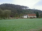
- Bubenheim is located directly on the Altmühl (420 to 440 meters above sea level) and stretches around the Bubenheimer Berg , on which types of rock from the Ries ejection ( meteorite impact fifteen million years ago) can be found. The place has around 410 inhabitants. It was mentioned as early as the 8th century, because in 792 Charlemagne visited Bubenheim on the occasion of the construction of the Carolina fossa . There is an airfield near the village .
- Dietfurt in Middle Franconia has around 450 inhabitants, forms the entrance to the Altmühltal and is at an altitude of 400 meters above sea level. The place was mentioned for the first time in 802, when Reginsind, the daughter of a Franconian nobleman, handed over her possessions to the St. Gallen monastery . In the Middle Ages, the marshals of Pappenheim were among the most important landlords .
- Falbenthal lies at an altitude of 520 m above sea level. NHN and was first mentioned in 1250 as "Walwental" owned by the Wülzburg monastery . Since the name of the place can be explained as a field name ("Siedlung ifdasm pale valley"), it was probably not founded before the 12th century. With the Wülzburg monastery, the place also came into the possession of the Margraves of Brandenburg-Ansbach at the end of the 14th century . In 1608 they enfeoffed Hans von Buchholz zu Helfenberg with Falbenthal. In 1642 the estate was acquired by Colonel Johann von Leubelfing . Today the former manor house only serves as a residential building.
- Graben : Das kleine (about 200 inhabitants), 410 m above sea level. NHN located village takes its name from the Karlsgraben ( Fossa Carolina ), of which earth walls and excavations still testify here today. In addition, a Karlsgraben exhibition is housed in the Hüttinger barn, which vividly reconstructs the building from over 1200 years ago. Also worth seeing is the Evangelical Lutheran Church of St. Kunigund , which has well-preserved late-Gothic frescoes . The village lies at the foot of the Nagelberg , on the plateau of which there is a so-called witch's dance place.
- Grönhart lies at an altitude of 425 m above sea level. NHN on a height of alluvial sand, from which the place derives its name (settlement on the sandy forest). Since this is also a field name, the place is likely to have originated in the 11th or 12th century. It was first mentioned in documents in 1251. The local knight family died out in the 13th century. In the following centuries, the Wülzburg Monastery, the Wiriche von Treuchtlingen and the Marshals von Pappenheim were well off there. The main European watershed is in the immediate vicinity of the village . A fountain was set up there in 1984, which discharges its water into two rivulets. One flows over the Altmühl to the Danube , the other over the Swabian Rezat to the Main and Rhine .
- Gundelsheim has about 500 inhabitants and is located in the Möhrenbachtal (460 to 480 meters above sea level). The place was first mentioned in 1065 and has a small church with baroque furnishings. The marble quarry is geologically interesting. There, ejecta rocks from the Ries are visible on the limestone, which at the time prompted American astronauts to pay a visit to Gundelsheim during their geological training in the Nördlinger Ries in August 1970. This marble was used, for example, in Berlin's Tempelhof Airport .
- Haag lies at an altitude of 515 m above sea level. NHN and was first mentioned in 1214 as a property of Marshal von Pappenheim. Since 1360 the goods but the monastery of St. Walburg in Eichstaett heard and the marshals only the Bailiwick law exercised, it is probably because of this ownership that the place in the 12th century was established by the monastery of St. Walburg. The name means "at the enclosed place". On a ledge lie the remains of a castle that is said to have been destroyed by Ludwig the Strict in 1263 .

- Möhren is located in the Möhrenbach valley ( 455 m above sea level ) and has around 580 inhabitants. The former castle of the Counts of Pappenheim and the Roman Catholic parish church of the Assumption of Mary with its rich baroque furnishings are worth seeing .
- Oberheumödern lies at an altitude of 500 m above sea level. NHN . The place was mentioned in documents in 1403 when Wirich and Jobst von Treuchtlingen pledged it. In 1596 the marshals of Pappenheim-Treuchtlingen were the owners, from whom the place passed to the margraves of Brandenburg-Ansbach. The school building from 1813, in which teaching was carried out until 1932, is worth seeing.

- Schambach is located near Treuchtlingen at the entrance to the scenic Schambachtal (411 to 520 meters above sea level) and has around 700 inhabitants. Excavations have shown that people have always settled at this conveniently located location. "Scammaha" was first mentioned in a document in 802. The church goes back to a Willibald church that already existed in the 8th century . Its compact structure barely towers above the houses in the town center.
- Schlittenhart was first mentioned in 1306 when Count Ulrich von Truhendingen sold the place "Slitenhart" to the knight Konrad von Rechenberg. Since 1486 the hamlet belonged to the monastery Heidenheim and with this later the margraves of Brandenburg-Ansbach.
- Unterheumödern , probably originated in the 12th century, was first mentioned in 1286 when the Wülzburg monastery granted Ulrich von Mittelburg income from the Möhrenberg, Wolfhausen and "haemedern" estates, which it had previously received from him. Later it belonged to the Teutonic Order in Ellingen , then Wirich and Ulrich von Treuchtlingen. In the 15th century the hamlet was pledged to the St. Klara monastery in Nuremberg . In 1596 the Marshal von Pappenheim-Treuchtlingen, and later the Margrave of Brandenburg-Ansbach, owned two farms and a house to "Vndterheumödern". Today there are only two full-time businesses in the village.
.png)
- Wettelsheim is located at the foot of the Hahnenkamm Mountains Patrich and Viersteinberg ( 450 m above sea level ) and has around 1500 inhabitants. The place is probably already in the 5th / 6th Century originated. The oldest church in the village is the Martinskirche at the foot of the Patrichberg. It was assigned to the Wülzburg monastery in the 13th century. During the renovation in 1958, frescoes from around 1058 came to light. The shrine altar from 1515 is worth seeing.

- Windischhausen is embedded in the delightful eastern Rohrbach valley ( 480 m above sea level ) and has around 150 inhabitants. It was first mentioned in documents in 1057 when the first church was consecrated. Over time, the Counts of Treuchtlingen, Wülzburg Monastery, Rebdorf Monastery and Heidenheim were wealthy there. The place name is probably derived from the ethnic group of the Slavs (Windisch = Slavic).
Dialect geography
Treuchtlingen is located in an area in which East Franconian and Bavarian dialect features mix. To the west of Treuchtlingen, the East Franconian and Bavarian dialects also meet Swabian , which is why the three-tribe corner is often used . To the west of Treuchtlingen, traffic communities gradually cleared into the woods, whose linguistic peculiarities only arose after the so-called migration of peoples in the Middle Ages and in the early modern period.
history
Until the 19th century
The village is one of the oldest settlements in the Treuchtlingen area. The Celts , Romans and Franks have left their cultural traces. Interdisciplinary research by the Technical University of Berlin from 2010 sees the Setuacotum, historically documented by Claudius Ptolemy , as the predecessor of Treuchtlingen. Under Carolingian rule, the Karlsgraben was built north of the city center in the district of Graben in 793 as the first waterway between the Rhine / Main and the Danube . The city itself was first mentioned in 899 (as Drutelinga ). In 1044 Agnes was married to Emperor Heinrich III. mentioned. The first castle, also known as the Upper Veste , was built around the middle of the 12th century . The castle ruins have been preserved since the mid-1970s by the Fördergemeinschaft Burg Treuchtlingen e. V. supervised. Around the year 1400 Treuchtlingen was raised to market , in 1495 it was largely destroyed by a major fire. After the death of Gottfried Heinrichs Graf zu Pappenheim in the battle of Lützen in 1632 and the extinction of the Treuchtlinger line after the death of his son Wolf Adam in a duel with Martin Maximilian von der Goltz , Treuchtlingen fell to the Margraves of Ansbach in 1647 , after mediation it became in 1809 Part of the Kingdom of Bavaria .


Until the 19th century, Treuchtlingen was a handicraft-oriented market town. The Treuchtlinger Hafner were known, the "Treuchtlinger crockery" was of national importance. Furthermore, the "Leonische Tressen - und Seidenmanufaktur " existed since 1774 and sold their goods worldwide. The construction of the first railway line Munich - Ingolstadt -Treuchtlingen - Gunzenhausen in 1869 and the associated infrastructure brought about a rapid upswing and made Treuchtlingen a railway town . The first hospital was built around 1875. The population increased by 2,000 this year to more than 3000 in 1895. 1898 Treuchtlingen received by Prince Regent Luitpold the city charter .
20th and 21st centuries
From 1917, the meritorious, non-party mayor Emil Sommer , a son of the printing company owner of the same name, was in office in Grünstadt . He was expelled in 1933 because of his partial Jewish descent. On February 23, 1945 at around 11:00 a.m. there was an air raid on Treuchtlingen train station ( Operation Clarion ), in which the SF 2046 front holiday train stopped. The passengers of the train fled into the platform underpass, which received a direct hit. 300 people died in the platform underpass, a total of almost 600 people were killed and another 900 injured in the station and the surrounding area. Most of the bomb victims are buried in the Memorial of the War Graves Commission on the Nagelberg . A marble plaque commemorates the victims in the underpass, which has been tunneling under the tracks at a different location since the station was renovated in 2004. In a second attack on April 11, 1945, no people were killed, but among other things a Bavarian G 3/4 H steam locomotive was destroyed. Part of the wreck was found during the renovation and is now in the Bavarian Railway Museum in Nördlingen .
Incorporations
On April 1, 1971, the previously independent communities of Bubenheim and Graben were incorporated. On July 1, 1971, Grönhart and Schambach joined them. Part of the dissolved municipality of Haag near Treuchtlingen followed on January 1, 1972. From the dissolved district of Gunzenhausen , Auernheim, Wettelsheim and Windischhausen were finally added on July 1, 1972, and Gundelsheim and Möhren from the dissolved district of Donauwörth . Dietfurt completed the series of incorporations on May 1, 1978.
To the origin of the place name
According to an older thesis, the personal name Truhtilo is in the place name Treuchtlingen . The reason students were therefore used to learn the little verse: "From Truhtilo the Alemanni (also Alamanni ) has Treuchtlingen . His name" Legend has it that after the Limes breakthrough of the Alemanni around 233 AD Alemanni groups at a ford of the.. Altmühl have settled. This later became "The village of Truhtilo ", Truhtiolingen and finally Treuchtlingen .
This personal name is nowhere used. According to Joachim Grzega , it can be assumed that the originally unknown form of the name was based on the word * truht 'Bündnis' and later on the word triu 'treu' (such forms of folk etymology can also be found in other place names).
The Jewish community

Jews lived in Treuchtlingen from the Middle Ages to the 20th century (1939). A first mention is made in connection with the persecution during the plague time of 1348/49, which also affected the local Jews. The development of the modern community goes back to the 17th / 18th centuries. Century back. In the course of the 18th century, one of the most important Jewish communities in Bavaria came into being in Treuchtlingen . The number of Jewish residents peaked in 1837 with 288 people (17.7 percent of a total of 1,590 inhabitants). Around 1925 there were 115 parishioners. Several Jewish associations shaped the community life. The Jewish families owned numerous commercial and industrial enterprises with considerable economic importance for the city. Today, almost only the Jewish cemetery is a reminder of centuries of Jewish history in the city, especially the memorial stone that has been erected there since 1990 and commemorates the local Jewish victims of the Shoah . Since 2009, a memorial stele next to the former Judenstadel , today's city library, has been commemorating all Jewish families who once lived in Treuchtlingen.
politics

City council
The 24 seats of the city council are distributed as follows:
| CSU | SPD | FDP | FW / UFW | Treuchtlinger Citizen List | Young community citizens | total | |
| 2002 | 10 | 9 | 1 | 2 | 2 | - | 24 seats |
| 2008 | 10 | 9 | - | 3 | 2 | - | 24 seats |
| 2014 | 8th | 9 | - | 3 | 2 | 2 | 24 seats |
| 2020 | 9 | 6th | - | 4th | 3 | 2 | 24 seats |
mayor
- Friedrich Grahl , 1894–1907
- Jacob Aurnhammer, 1888 to 1894 and 1907 to 1909
- Ludwig Staudinger, 1909–1912
- Karl Kraft, 1912–1918
- Emil Otto Sommer , 1918–1933
- Andreas Güntner, 1933–1945
- Friedrich Korn, 1946–1956
- Hans Döbler, 1956–1984
- Wolfgang Herrmann (CSU), 1984-2008
- Werner Baum jun. (SPD), 2008-2020
- Kristina Becker (CSU), elected on March 15, 2020
Partnerships
Treuchtlingen has partnerships with the Italian Ponsacco (since 2003) and with the Hungarian Bonyhád (since 2011).
Culture and sights
Buildings

- The city palace from the 16th century is a former moated palace of the Pappenheimers and Ansbachers. The future Marshal in the Thirty Years' War , Gottfried Heinrich Graf zu Pappenheim, was born there on May 29, 1594 . He fell in the Battle of Lützen in 1632. The quote from the drama Wallenstein's Death by Friedrich von Schiller is coined on him : “ This is how I recognize my Pappenheimers ”. In the city park of Treuchtlingen there is a replica of a torture cross that the count had erected at the former western entrance to the market town at that time.
- The castle ruin Obere Veste , Treuchtlingen Castle , from the first half of the 12th century was sponsored by the Fördergemeinschaft Burg Treuchtlingen e. V. has been refurbished in numerous actions since 1974. The finds uncovered during excavations can be viewed in the local museum. The castle ruins are freely accessible; on weekends when the castle parlor is open, the keep can also be climbed. From there you have a good overview of the city.
- The Folklore Museum Treuchtlingen is a former trimmings factory and is located opposite the former castle. Here you can see a permanent exhibition about the Treuchtlingen castle ruins and interesting finds from excavations dating back to Celtic history.
- Villa Rustica . On the southeastern slope of the Nagelberg, in the immediate vicinity of the Weinberghof, are the remains of a manor from Roman times.
- Lambertus Chapel (Catholic). It was first built in the 9th or 10th century, but destroyed several times. The current building dates from 1733/1734.
- Marienkirche (Catholic), built in 1933/34 from local Jura rubble.
- Margrave Church . After the death of the last Pappenheimer Gottfried Heinrich, the Treuchtlingen market fell to the Margraves of Brandenburg-Ansbach , later Brandenburg-Ansbach-Bayreuth, whoadhered tothe Reformation . In 1757 the Margrave of Ansbach had the Protestant church built near the Altmühl. The church was renovated from 1998 to 2002.
- War cemetery on the Nagelberg . Around 400 dead in the bombingof the Treuchtlingen train station on February 23, 1945 as well as around 2,100 other fallen soldiers and civilian victims of the Second World War are buried here.
- Jewish cemetery . The cemetery, which was laid out in 1773 and is now closed, is a reminder of the Jewish community that existed in Treuchtlingen for centuries and was one of the most important in the region. The preserved Tahara house , some of the sometimes elaborately designed tombstones and a memorial by the local artist Franz Peter Burger, which commemorates the Jewish victims of the tyranny from 1933 to 1945, canbe seen from outside.
Architectural monuments
Events
- Castle Festival
- Every year on the third weekend in June, the castle festival takes place on the square below the castle ruins. On special occasions, in 1998 (100 years of town elevation - 1000 years of Treuchtlingen), 2000 (25 years of the Burgverein), the castle festival is presented in a historical guise. A historical castle festival took place on June 23 and 24, 2007 ; The occasion was the 30th Castle Festival.
- Treuchtlinger Volksfest
- It starts on the second Friday in July. The festival lasts ten days. The venue is the fairground.
- Eber-Hart Festival On the first weekend in September there will be an open air for newcomer bands in the marble factory near Treuchtlingen
Parks
Sculptures and sculptures can be seen in the spa gardens.

Treuchtlingen spa gardens
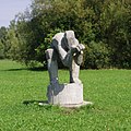
Lurking by Christian Rösner

Treuchtlingen spa gardens
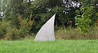
Treuchtlingen spa gardens


Photo gallery
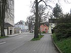
Bahnhofstrasse, Catholic Church

Center, Bahnhofstrasse
Sawmill

War cemetery Treuchtlingen
.jpg)
.jpg)

Economy and Infrastructure
traffic

The Federal Highway 2 runs east around 2 kilometers away at Treuchtlingen over. The state roads St 2216 , St 2217 and St 2230 connect the city with the surrounding communities.
The station Treuchtlingen is an important railway junction . This is where the lines from Treuchtlingen to Würzburg and Ingolstadt – Munich (Altmühlbahn) intersect with the Donauwörth – Treuchtlingen and Treuchtlingen – Nuremberg lines . After the opening of the new Nuremberg – Ingolstadt line , it lost its importance for long-distance passenger transport, but is still a hub for national freight transport. The station belongs to the transport association for the greater Nuremberg area . It has been extensively modernized and is currently served by regional trains in BayernTakt as well as by individual InterCity and InterCityExpress trains (as of July 2011). The station has lost its original meaning in local freight traffic; for years it has only been used to park block trains, mainly car transport wagons and tank wagons, which are called up from Ingolstadt ( Audi works and refineries) as required. Gravel is currently only loaded irregularly in Treuchtlingen.
The Nuremberg Airport is around 75 kilometers away; there is also a landing site in Treuchtlingen-Bubenheim .
Education and Research
The Senefelder School in Treuchtlingen, which bears the name in honor of Alois Senefelder , is a state cooperative comprehensive school with middle school, secondary school and grammar school. It is home to around 1,300 students from the entire Weißenburg-Gunzenhausen district.
The University of Applied Management started operations in October 2010 . The first course is sports management .
health care
The Treuchtlingen city hospital was founded in 1898 as an in-patient clinic. The facility specialized in geriatrics (acute geriatrics and geriatric rehab) and was renamed the Treuchtlingen Health Center together with care for the elderly . Operations will be discontinued in 2018. The district clinics of Middle Franconia set up a specialist clinic for psychosomatics with 140 beds.
Established businesses
- Altmühltaler mineral fountain , mineral water bottler
- Strong. Paint shop, supplier to the automotive industry
- Treuchtlinger Marble Works, Haag district. Quarry
- Alfmeier Präzision SE , supplier to the automotive industry
- Franken-Schotter, districts Dietfurt and Möhren. Quarry
- Jura marble works pond, district Gundelsheim. Quarry
- Hans Hirschmann KG Bauunternehmung GmbH & Co, road, canal and building construction
- KraussMaffei Technologies GmbH , manufacturer of plastic machines
Former companies
- VC Limonadenfabrik Pledl (end of production October 31, 2014)
- KB plastic coating, surface coating and mold making
media
- The daily newspaper Treuchtlinger Kurier , a local edition of the Nürnberger Nachrichten and the weekly newspaper Stadtzeitung Weißenburg .
Personalities
IT infrastructure with free software
In 2001, the city administration of Treuchtlingen, with Heinz-Markus Gräsing as IT manager, became the first city in Germany to convert its infrastructure to free software . At this point in time, the switch was still very difficult because the IT industry was not prepared for it. Three years later, on November 24, 2004, the companies involved celebrated the three-year existence of the new infrastructure under the title 1000 Days of Tux . At this point in time, the mayor, as one of the greatest critics , admitted for the first time that he would take the step again and support the migration from now on. From the migration efforts of the city of Treuchtlingen and the resulting open government platform, many collaborations developed with which other city administrations could be supported in this step.
literature
- Johann Kaspar Bundschuh : Treuchtling . In: Geographical Statistical-Topographical Lexicon of Franconia . tape 5 : S-U . Verlag der Stettinische Buchhandlung, Ulm 1802, DNB 790364328 , OCLC 833753112 , Sp. 577-578 ( digitized version ).
- Daniel Burger , Birgit Friedel: Castles and palaces in Middle Franconia. ars vivendi Verlag, Cadolzburg 2003, ISBN 3-89716-379-9 , pp. 125–128.
- Jörg and Rolf Frank: Treuchtlingen Railway Cross. BUFE Verlag, Munich.
- Walter E. Keller: Treuchtlingen. (= Series of yellow paperback guides). wek-Verlag , Treuchtlingen / Berlin 2006, ISBN 3-934145-31-0 .
- Walter E. Keller (Ed.): The village of Schambach. wek-Verlag, Treuchtlingen 2002, ISBN 3-934145-15-9 .
- Gotthard Kießling: Weissenburg-Gunzenhausen district. (= Monuments in Bavaria. 70/1). Munich 2000, ISBN 3-87490-581-0 .
- Josef Lidl : Heimatbuch Treuchtlingen. Ed .: Heimat- u. Bäderverein Treuchtlingen eV 1984.
- Arthur Rosenbauer : Forgotten secrets, rediscovered ... wek-Verlag, Treuchtlingen / Berlin 2010, ISBN 978-3-934145-81-8 .
- Arthur Rosenbauer, A village saves its dialect- The language island of Auernheim; wek-Verlag: Treuchtlingen / Berlin 2015; ISBN 978-3-934145-95-5
- Werner Somplatzki: Churches in Altmühlfranken. (= Series of yellow paperback guides). wek-Verlag, Treuchtlingen 1990, ISBN 3-924828-34-2 , pp. 70-73 and 76-85.
- Gottfried Stieber: Trainees . In: Historical and topographical news from the Principality of Brandenburg-Onolzbach . Johann Jacob Enderes, Schwabach 1761, p. 809-818 ( digitized version ).
- Pleikard Joseph Stumpf : Treuchtlingen . In: Bavaria: a geographical-statistical-historical handbook of the kingdom; for the Bavarian people . Second part. Munich 1853, p. 726 ( digitized version ).
Web links
- Map of the urban area of Treuchtlingen on: BayernAtlas of the Bavarian State Government ( information )
- Information on the city's Jewish history
- Entry on the coat of arms of Treuchtlingen in the database of the House of Bavarian History
- Treuchtlingen: Official statistics of the LfStat
- Interactive 360 ° panorama photos from Treuchtlingen by Qualipano
Individual evidence
- ↑ "Data 2" sheet, Statistical Report A1200C 202041 Population of the municipalities, districts and administrative districts 1st quarter 2020 (population based on the 2011 census) ( help ).
- ^ Community Treuchtlingen in the local database of the Bavarian State Library Online . Bayerische Staatsbibliothek, accessed on December 25, 2019.
- ↑ Website of the city of Treuchtlingen ( Memento of the original from December 26, 2013 in the Internet Archive ) Info: The archive link was inserted automatically and has not yet been checked. Please check the original and archive link according to the instructions and then remove this notice.
- ↑ Werner König, Manfred Renn: Small linguistic atlas of Bavarian Swabia. Augsburg 2007, pp. 25 and 30.
- ^ Christian Marx, Dieter Lelgemann, Eberhard Knobloch, Andreas Kleineberg: Germania and the island of Thule . Scientific Book Society, Darmstadt 2010, ISBN 3-534-23757-9 .
- ↑ The departure. In: Weißenburger Tagblatt. 4th August 2012.
- ^ Website of the city of Treuchtlingen on Mayor Sommer
- ^ Wilhelm Volkert (ed.): Handbook of Bavarian offices, communities and courts 1799–1980 . CH Beck, Munich 1983, ISBN 3-406-09669-7 , p. 593 .
- ^ Federal Statistical Office (ed.): Historical municipality directory for the Federal Republic of Germany. Name, border and key number changes in municipalities, counties and administrative districts from May 27, 1970 to December 31, 1982 . W. Kohlhammer, Stuttgart / Mainz 1983, ISBN 3-17-003263-1 , p. 731 .
- ↑ Joachim Grzega: On the history of the place name Treuchtlingen in Middle Franconia. In: Yearbook for Franconian State Research. 66, 2001, pp. 1-8.
- ↑ Memorial sites for the victims of National Socialism. A documentation. Volume 1, Federal Agency for Civic Education, Bonn 1995, ISBN 3-89331-208-0 , p. 195.
- ↑ 50 years of the war cemetery on the Nagelberg. In: Treuchtlinger Kurier. October 10, 2011.
- ↑ nordbayern.de of September 21, 2018
Auernheim with Freihardt , Hagenhof , Schlittenhart and Wieshof | Bubenheim | Dietfurt in Middle Franconia with Bergnershof | Dig | Grönhart with Hagenau , Naßwiesen and Neuheim | Gundelsheim | Haag near Treuchtlingen with Dickmühle , Hürth , Mattenmühle , Neufang , Rutzenhof , Schürmühle and quarry | Carrots with Eichhof , Fuchsmühle and Spielhof | Schambach with Bonhof , Kohlmühle , Lehnleinsmühle , Upper Paper Mill , Lower Paper Mill and Weinbergshof | Treuchtlingen with Eulenhof , Gstadt , Heunischhof , Kästleinsmühle , Metzenhof , Möhrenberg , Sägmühle , Schertnershof , Schmarrmühle , Siebeneichhöfe and Ziegelhütte | Wettelsheim with Dornmühle , Falbenthal , cellar house , brick mill and customs mill | Windischhausen with Oberheumödern and Unterheumödern

Absberg | Alesheim | Mountains | Burgsalach | Dittenheim | Ellingen | Ettenstatt | Gnotzheim | Gunzenhausen | Haundorf | Heidenheim | Höttingen | Langenaltheim | Berolzheim market | Meinheim | Muhr am See | Nennslingen | Pappenheim | Pfofeld | Pleinfeld | Polsingen | Raitenbuch | Solnhofen | Theilenhofen | Treuchtlingen | Weißenburg in Bavaria | Westheim