
Berolzheim market
| coat of arms | Germany map | |
|---|---|---|

|
Coordinates: 49 ° 1 ' N , 10 ° 51' E |
|
| Basic data | ||
| State : | Bavaria | |
| Administrative region : | Middle Franconia | |
| County : | Weissenburg-Gunzenhausen | |
| Management Community : | Altmuehltal | |
| Height : | 424 m above sea level NHN | |
| Area : | 14.55 km 2 | |
| Residents: | 1281 (Dec. 31, 2019) | |
| Population density : | 88 inhabitants per km 2 | |
| Postal code : | 91801 | |
| Area code : | 09146 | |
| License plate : | WUG, GUN | |
| Community key : | 09 5 77 149 | |
| Market structure: | 2 parts of the community | |
Market administration address : |
Großholzer Weg 11 91801 Markt Berolzheim |
|
| Website : | ||
| Mayor : | Fritz Hörner ( GREEN / Independent List) | |
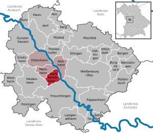
| Location of the Markt Berolzheim market in the Weißenburg-Gunzenhausen district | ||
  |
||

.jpg)
Markt Berolzheim ( colloquial. "B-Heim", pronounced Beheim and in earlier times - until the 1970s - "Berlza") is a market in the central Franconian district of Weißenburg-Gunzenhausen and a member of the Altmühltal administrative community based in Meinheim .
geography

Geographical location
The place is above the Altmühl in the Altmühltal at the foot of the Hahnenkamm , a mountain range of the Franconian Alb , at about 420-500 meters above sea level. NHN . The area is located in West Central Franconia and is also known as Altmühlfranken . Not far to the west of the village is the Berolzheim Forest . The highest point in the community is the Gemeindeberg (approx. 625 m ). State road 2230 and the Treuchtlingen – Würzburg railway line run through the village . In the forest area near Markt Berolzheim there are several springs that flow together to form the Berolzheimer Mühlbach . Another river in the municipality is the Vordere Graben . It flows into the Altmühl, which forms the eastern border of the municipality. Nearby cities are Treuchtlingen , Weißenburg in Bayern and Gunzenhausen . The hamlet of Großholz belongs politically, the hamlet of Lengenfeld ecclesiastically to Markt Berolzheim. The Buchleite nature reserve is located south of the village , and the Hunnenstein, southwest of Markt Berolzheim , is a geotope .
The neighboring communities are:
| My home | My home | Alesheim |
| Heidenheim , Meinheim |
.svg)
|
Alesheim |
| Heidenheim | Treuchtlingen , | Alesheim , Treuchtlingen |
Community structure
The municipality has two officially named parts of the municipality (the type of place is given in brackets ):
- Large wood ( wasteland )
- Berolzheim market (main town)
The district of Markt Berolzheim exists. Markt Berolzheim is the municipality with the fewest districts in the Weißenburg-Gunzenhausen district.
geology
The municipality is on the edge of the Hahnenkamm, part of the Altmühlalb . In high altitudes limestone ( Malm ), over sandstone ( Dogger ) into clay ( Lias ).
climate
The climate of Markt Berolzheim is characterized by a weaker medium mountain climate . The solar maximum is in June and July, the minimum precipitation in March. Average rainfall is 650–800 millimeters per year, in winter around 35 days of snowfall. The annual mean temperature is 7.8 ° C.
history
Until the 18th century
The first traces of human life are from around 10,000 BC. Demonstrable. A first permanent settlement is likely around 3800 BC. Be done.
During the reign of Emperor Trajan , a Roman settlement in the province of Raetia was established there ; A Roman villa was found in the Steinhausäcker corridor . In the 6th century there was another settlement north of an already existing settlement called Benzing on the opposite side of the Dorfbach with Berol (t) sheim, perhaps as the seat of a Frankish clan leader named Berolt or Berolf. In the course of time, the name of the new place was also transferred to the original settlement. In the 8th century, in the time of Charlemagne , the area belonged to the Sualafeldgau . Two parishes, which belonged to the Eichstätt diocese and have been Evangelical-Lutheran since the Reformation, were probably established as early as the 11th century . In 1129 and later the place name appeared as Peroluesheim, in 1167 as Berolteshaim.
From the 11th century, the town had three noble residences (castles), the standing on the edge, probably built on Roman foundations Steinhaus am Goppelt , which went off as the first of the castles, a first time in 1326 mentioned "strongly reinforced water house", the castle Berolzheim that later Lower Castle, opposite the “probably in the 8th / 9th century. The chapel (and today's parish church) of St. Michael was built in the 16th century on the site of a Celtic-Roman sanctuary , and the Upper Castle near the St. Mary's chapel, which was consecrated in 1183 and which was named St. Bartholomäus parish church appeared. The local nobility "von Berolzheim" called themselves a Tageo in 1129, a Heinrich in 1167, a Marquard in 1212 and a Willing in 1326 and 1344. From 1332 the aristocratic family Frick appeared, then the Vestenberg and 1370 the Lentersheim . In 1574 Wolfgang II von Pappenheim acquired the Upper Palace. In 1311 the Truhendinger , the Salacher , 1332 the Holzinger , 1477 the Emser and 1572 the Pappenheimer sat at the lower castle ; In 1667 the Ansbach margraves had the property. As in many places in the Middle Ages, the manor was therefore very fragmented. A Salbuch from 1491 also shows that Berolzheim owned the Auhausen monastery .
In 1574 the community received an imperial letter of coat of arms in which Berolzheim is referred to as "Fleckhen"; it is uncertain whether this meant a market town. In the Thirty Years' War the place was devastated and burned down by the Lorraine in 1631 and seven years later it was sacked by imperial Bavarian troops; only five houses remained. The choir tower of the upper church also fell victim to the war; it was restored in 1688 while the nave was expanded at the same time.
In 1667 the Margraves of Bayreuth-Ansbach bought the place from local heirs and set up their own administration office there. In addition to the manorial administration, the Vogtamtsverwalter held the lower jurisdiction ; Until 1797, the Hohentrüdingen District Office was responsible for the high court. The Cathedral Chapter Office of Pleinfeld was responsible for the Eichstätter property in Berolzheim . In 1783, a major fire left only 40 houses of the 125 properties; the Ansbach fire insurance introduced in 1754 made a "neat reconstruction" possible. From 1758 to 1760 the nave of the lower church was rebuilt in margrave style. When in 1797 the Hohentrüdingen Oberamt and thus the Berolzheim administration office was transformed into the Heidenheim Chamber and Justice Office in the Wassertrüdinger district , Berolzheim received one of the two court clerks.
19th and 20th centuries
In 1806 Berolzheim became part of the Kingdom of Bavaria and in 1808, together with the wasteland Großholz, where two families lived, it became a tax district and in 1809 a municipality , and in 1818 a market in the Heidenheim district court . In 1809 there were 143 house numbers (125 houses), in 1824 there were 166 properties with 966 inhabitants. In 1835 the village of Windischhausen was separated from the Upper Parish as an independent parish; Originally belonging to the deanery of Hechlingen / Dittenheim / Heidenheim, the two parishes of Markt Berolzheim have been assigned to the Evangelical Lutheran deanery in Pappenheim since 1925 . The municipality has been called Markt Berolzheim since 1920 . In 1950 there were 223 properties and 1,495 inhabitants.
.jpg)
Religions
The vast majority of the population is Protestant , only a small part is Catholic .
- The Protestant congregation is divided into the parishes of St. Maria (Upper Church) and St. Michael (Lower Church), which have, however, formed a common pastoral office since 1941, but still have separate church councils. The residents of the hamlet of Lengenfeld, which lies on the other bank of the Altmühl, belong to the Protestant community. Services take place alternately in both churches, only the church consecration of St. Mary is celebrated in public.
- The Catholic parish of St. Hedwig , a curate of the parish of the Assumption of Mary in Treuchtlingen, only came into being in the post-war period through the influx of refugees from eastern Germany, mainly from the Sudetenland . The church, an equilateral pentagon with a freestanding bell tower in plan, is the work of Ingolstadt architect Josef Elfinger († 1988) and was built in 1961. Inside, thanks to the glass mosaics by Max Wendl, it appears to be “flooded with warm light”.
- There was a Jewish community in Markt Berolzheim from the 17th century (first mentioned in 1631) to 1938. In the first half of the 19th century, almost 20% of the population were at times of the Israelite faith (174 Jewish inhabitants out of a total of 898). In 1933 there were still 65 Jewish residents. The synagogue (location "In der Hölle") was burned down during the November pogrom in 1938. The last 24 Jewish residents were imprisoned and evicted. At the site of the synagogue there is now a memorial to the former Jewish community. The Jewish family names Berolzheimer and Berlitzheimer are reminiscent of the local Jewish settlement in various countries around the world. The ancestors of the founder of the Berlitz language schools also come from Markt Berolzheim.
Population development
In 1809 912 residents had their place of residence. By 1933 the village had grown to 1,063 inhabitants. This was followed by the annihilation of around 100 people in the Jewish community during the Reichspogromnacht in 1938, as well as the influx of refugees from eastern Germany after the war. The community grew to around 1,500 inhabitants by 1950, with a decrease to 1,150 in the following years. In recent years, the place has grown to around 1350 inhabitants due to new settlements, also due to increased immigration from the city triangle of Treuchtlingen, Gunzenhausen and Weißenburg .
politics
Market council
The municipal council consists of twelve members.
| CSU | SPD | Green | Citizen List | total | |
| 2002 | 6th | 3 | 2 | 1 | 12 seats |
| 2008 | 5 | 2 | 4th | 1 | 12 seats |
| 2014 | 3 | 3 | 4th | 2 | 12 seats |
mayor
Fritz Hörner (Bündnis 90 / Die Grünen) was elected First Mayor of the market in the local elections in 2008 and replaced Hermann Bauer (CSU) on May 1, 2008, who no longer ran for election.
Previous mayor (or mayor until 1881):
- 1837-1840: Bleacher
- from 1840: Cramer
- until 1862: no records
- 1862–1863: Georg Bieber
- 1863–1881: Joh. Georg Hüttmeier
- 1882–1906: Leonhard Prosiegel
- 1906–1919: Paul Büttner
- 1919–1932: Karl Guthmann
- 1933–1945: Friedrich Seegmüller
- 1945: Christian Haag (installed by the American military government )
- 1945–1948: Karl Weißlein sen. (used by the American military government)
- 1948–1978: Ludwig Reichardt
- 1978-2008: Hermann Bauer (CSU)
coat of arms
Blazon : “Divided by blue and silver, a silver iron hat on top, a black bear walking forward with a red tongue and collar below.” The iron hat stands for the town of Pappenheim , to which Markt Berolzheim belonged in the Middle Ages, the bear stands for the Noble Berolt, who gave the place its name.
Culture and sights
Buildings


.jpg)
In addition to the three churches and the memorials for war victims, the Berolzheim beer cellars on the edge of the forest are among the buildings worth seeing. The latter, built around 1850, were renovated a few years ago and are now used as warehouses for harvest and equipment from farmers and forest workers.
The origin of the Protestant churches since the Reformation is unclear. Already in 1186 there was a report about the renovation of a house of God in documents - whether that meant St. Maria or St. Michael is unknown.
- Church of St. Maria: Mentioned in a document as early as 1329 as a chapel of the Upper Castle (hence the common name Upper Church), it is one of the oldest churches in the district. From 1352 referred to as a parish church , it was originally a choir tower church , a building typical of the region with a short, square tower with an integrated chancel and a relatively small nave . However, this peculiarity was lost through the destruction of the church in the Thirty Years War in 1632 and the subsequent expansion; today the church has a high, pointed tower roof in which kestrels nest. On the top of the tower there is a weather vane in the shape of an elephant. A first Protestant pastor can be traced back to 1528. In 1688 the tower was first rebuilt, later the nave. In 1751 a strong storm tore down the top of the tower; the renovation was not carried out until four years later. In 1916 lightning struck the tower and the roof structure burned down. The church has three bells from 1436, 1673 and 1925. The two older bells were supposed to be melted down during World War II. After the war, however, they were found in Hamburg and the church received them back to the delight of the community. The church in its current state of construction in the middle of a cemetery is a typical representative of Ansbach Protestantism ( margrave style ).
- Church of St. Michael: First mentioned in a document in 1344, it was a church building similar to St. Maria. The Eichstätter cathedral chapter had the right of presentation. After the Upper Church, St. Michael became Protestant as the Lower Church in 1571. In 1758 the nave of the church was partially demolished and rebuilt by the Ansbach court builder Johann David Steingruber . The tower was rebuilt several times after a lightning strike in 1777, most recently in 1838. There are five bells hanging in the tower from 1702, 1926 (one from 1715 was melted down in World War I), 1973 and 1982. The fifth bell is the oldest and dates from the time when the Tower was erected.
- Church of St. Hedwig : Due to the large number of post-war refugees from eastern Germany, Curate Schneid suggested the construction of a Catholic church, which was consecrated on the second Sunday of Advent in 1962. The church was severely damaged in 1984 by an explosive explosion in a neighboring barn. Its construction corresponds to a typical, modern church; The architect was Josef Elfinger from Ingolstadt . It is the common church for the Catholics in Markt Berolzheim and Treuchtlingen-Wettelsheim.
Natural monuments
There are five natural monuments and three designated nature reserves within the municipality.
- Above the village, the Buchleite was designated as the 48th nature reserve of Middle Franconia in 1994 , an approximately 30 hectare northern slope typical of the Hahnenkamm and the Altmühltal Nature Park with orchards , hats and meadows grazed by sheep. There are also seven 300-year-old linden trees, the "Seven Linden trees", one of the natural monuments. In the middle of these linden trees is a trough for sheep.
- Altmühlfeuchtwiesen on the border with the Trommetsheim district; the areas up to the old, original Altmühl are in the Markt Berolzheim municipality
- Göppelt natural forest reserve, a 40 hectare mixed deciduous forest area with some spring water outlets
- Various linden trees around the place, age between 90 and 150 years
- "Hunnensteine" not far from the former quarry on the Jura plain, probably breccias from the meteor impact in the Nördlinger Ries . Originally there were two stones; the lying stone was removed by strangers.
Regular events
The parish fair takes place every third weekend in August . This is a typical Franconian tavern church fair.
Economy and Infrastructure
The market belongs to Region 8 of the Central Franconia administrative district and is designated as a small economic center . While there are sometimes no shops and only a few commercial operations in neighboring communities, some businesses and shops have survived in the village.
traffic
- Road: Connection to the state road 2230 Treuchtlingen – Gunzenhausen, as well as the local connecting road to Trommetsheim and the community connecting route to Großholz
- Railway: The Gunzenhausen – Treuchtlingen railway line opened on October 2, 1869. Until 1978, there was a stop for local trains, from 1982 the station was dismantled and closed
- Bus routes: After the rail traffic was discontinued, the Gunzenhausen – Treuchtlingen bus route started, now the VGN bus route. There is also a VGN line from Weißenburg to Markt Berolzheim.
- The Altmühltalradweg long-distance bike path runs east of the village .
education
- Elementary school Markt Berolzheim with elementary and secondary school in the Markt Berolzheim-Dittenheim school association.
- Kindergarten Villa Kunterbunt of the Protestant parish St. Maria / St. Michael , co-financed by the community. It offers space for 75 children in three groups.
Sons and daughters of the church
- Kaspar Achatius Beck (1685–1733), lawyer
- Johann Carl Cramer (1825–1850), Baptist pioneer in Bremen and East Frisia
- Theodor Doerfler (1869–1938), lawyer and politician
- David Rosenbaum (1877–1958), businessman.
- Carl Carben († 1928), Berolzheim's local historian
- Hans Doerfler (1863–1942), secret medical councilor, pioneer of general surgery and head physician at the Weissenburg i. Bay.
literature
- Sieglinde Buchner: Benzing and Bratting or the early history of Markt Berolzheim . In: Alt-Gunzenhausen. Contributions to the history of the city and the surrounding area . 52 (1997), pp. 39-48.
- Johann Kaspar Bundschuh : Berolsheim . In: Geographical Statistical-Topographical Lexicon of Franconia . tape 1 : A-egg . Verlag der Stettinische Buchhandlung, Ulm 1799, DNB 790364298 , OCLC 833753073 , Sp. 365-366 ( digitized version ).
- Carl Carben: Contributions to the local history of Markt-Berolzheim . Published by the municipality of Markt-Berolzheim. Gunzenhausen 1929, VII, 86 pages
- Hanns Hubert Hofmann : Gunzenhausen-Weißenburg . In: Historical Atlas of Bavaria , part of Franconia . Series I, Issue 8. Komm. Für Bayerische Landesgeschichte, Munich 1960, DNB 452071089 ( digitized version ).
- Georg Paul Hönn : Beroldsheim . In: Lexicon Topographicum of the Franconian Craises . Johann Georg Lochner, Frankfurt and Leipzig 1747, p. 317 ( digitized version ).
- Wilhelm Kraft: Berolzheim market. What the name of the place teaches us . In: Gunzenhauser Heimat-Bote , Volume IV (1934), No. 33 and 34.
- Reinhard Kufeld: The Evangelical Luth. Churches of St. Michael and St. Maria in Markt Berolzheim . Berolzheim market: Evang.-Luth. Parish office 1998.
- D. Schattenmann: The early history of market Berolzheim . In: Alt-Gunzenhausen. Contributions to the history of the city and the surrounding area . Issue 13 (1936), pp. 28-33
- Berolzheim market . In: Johann Schrenk and Karl Friedrich Zink : God's houses. Church leader in the district of Weißenburg-Gunzenhausen . Treuchtlingen / Berlin: wek-Verlag 2008, pp. 125–128
- Berolzheim market - from the past and the present. The update of the Carl Carben Chronicle . Published by the Heimatverein in 1998
- Pleikard Joseph Stumpf : Beroldsheim . In: Bavaria: a geographical-statistical-historical handbook of the kingdom; for the Bavarian people . Second part. Munich 1853, p. 725-726 ( digitized version ).
Web links
- Information page on the Jewish history of Markt Berolzheim
- Official homepage of the market
- Official homepage of the ev. Parish of Markt Berolzheim
- Entry on the coat of arms of Markt Berolzheim in the database of the House of Bavarian History
Individual evidence
- ↑ "Data 2" sheet, Statistical Report A1200C 202041 Population of the municipalities, districts and administrative districts 1st quarter 2020 (population based on the 2011 census) ( help ).
- ^ Community Markt Berolzheim in the local database of the Bavarian State Library Online . Bayerische Staatsbibliothek, accessed on December 25, 2019.
- ↑ a b Buchner, p. 47.
- ↑ Collective sheet of the historical association Eichstätt 46/47 (1931/32), p. 103, 50/51 (1935/36), p. 29.
- ↑ Buchner, p. 4.
- ↑ Collection sheet HV Eichstätt 46/47 (1931/32), p. 107
- ↑ Kufeld, p. 3, Schrenk / Zink, p. 127, Buchner, p. 45.
- ↑ Carbene, p. 34.
- ↑ Collection sheet HV Eichstätt 39 (1924), p. 4
- ↑ Historical Atlas of Bavaria. Schwaben series I issue 8: Nördlingen, p. 304.
- ↑ Carbene, p. 52.
- ↑ Collection sheet HV Eichstätt 48 (1933), p. 32.
- ↑ Kufeld, p. 4f.
- ↑ Schrenk / Zink, p. 127f.
- ↑ Carbene, p. 35.
- ^ Hanns Hubert Hofmann : Gunzenhausen-Weißenburg . In: Historical Atlas of Bavaria , part of Franconia . Series I, Issue 8. Komm. Für Bayerische Landesgeschichte, Munich 1960, DNB 452071089 , p. 43 ( digitized version ).
- ^ Hanns Hubert Hofmann : Gunzenhausen-Weißenburg . In: Historical Atlas of Bavaria , part of Franconia . Series I, Issue 8. Komm. Für Bayerische Landesgeschichte, Munich 1960, DNB 452071089 , p. 64 ( digitized version ).
- ^ A b Hanns Hubert Hofmann : Gunzenhausen-Weißenburg . In: Historical Atlas of Bavaria , part of Franconia . Series I, Issue 8. Komm. Für Bayerische Landesgeschichte, Munich 1960, DNB 452071089 , p. 107 ( digitized version ).
- ^ Hanns Hubert Hofmann : Gunzenhausen-Weißenburg . In: Historical Atlas of Bavaria , part of Franconia . Series I, Issue 8. Komm. Für Bayerische Landesgeschichte, Munich 1960, DNB 452071089 , p. 92 ( digitized version ).
- ^ Hanns Hubert Hofmann : Gunzenhausen-Weißenburg . In: Historical Atlas of Bavaria , part of Franconia . Series I, Issue 8. Komm. Für Bayerische Landesgeschichte, Munich 1960, DNB 452071089 , p. 53 ( digitized version ).
- ↑ Schrenk / Zink, p. 126.
- ^ Hanns Hubert Hofmann : Gunzenhausen-Weißenburg . In: Historical Atlas of Bavaria , part of Franconia . Series I, Issue 8. Komm. Für Bayerische Landesgeschichte, Munich 1960, DNB 452071089 , p. 220 ( digitized version ).
- ^ A b c Hanns Hubert Hofmann : Gunzenhausen-Weißenburg . In: Historical Atlas of Bavaria , part of Franconia . Series I, Issue 8. Komm. Für Bayerische Landesgeschichte, Munich 1960, DNB 452071089 , p. 236 ( digitized version ).
- ^ Hanns Hubert Hofmann : Gunzenhausen-Weißenburg . In: Historical Atlas of Bavaria , part of Franconia . Series I, Issue 8. Komm. Für Bayerische Landesgeschichte, Munich 1960, DNB 452071089 , p. 263 ( digitized version ).
- ^ Wilhelm Volkert (ed.): Handbook of Bavarian offices, communities and courts 1799–1980 . CH Beck, Munich 1983, ISBN 3-406-09669-7 , p. 477 .
- ↑ Schematism of the Diocese of Eichstätt 2007, p. 167.
- ↑ Schrenk / Zink, p. 128.
- ^ Carbene, p. 43
- ↑ Carbene, p. 45
- ↑ St. Willibalds-Bote Eichstätt of October 1, 1961, p. 12 (laying of the foundation stone)
- ↑ on the term "Jura" see → Jura (mountains) #Beeutungsfeld Jura mountain ranges

Absberg | Alesheim | Mountains | Burgsalach | Dittenheim | Ellingen | Ettenstatt | Gnotzheim | Gunzenhausen | Haundorf | Heidenheim | Höttingen | Langenaltheim | Berolzheim market | Meinheim | Muhr am See | Nennslingen | Pappenheim | Pfofeld | Pleinfeld | Polsingen | Raitenbuch | Solnhofen | Theilenhofen | Treuchtlingen | Weißenburg in Bavaria | Westheim