
My home
| coat of arms | Germany map | |
|---|---|---|

|
Coordinates: 49 ° 2 ' N , 10 ° 49' E |
|
| Basic data | ||
| State : | Bavaria | |
| Administrative region : | Middle Franconia | |
| County : | Weissenburg-Gunzenhausen | |
| Management Community : | Altmuehltal | |
| Height : | 433 m above sea level NHN | |
| Area : | 16.36 km 2 | |
| Residents: | 841 (Dec. 31, 2019) | |
| Population density : | 51 inhabitants per km 2 | |
| Postal code : | 91802 | |
| Area code : | 09146 | |
| License plate : | WUG, GUN | |
| Community key : | 09 5 77 150 | |
| LOCODE : | DE MHI | |
| Community structure: | 9 parts of the community | |
| Address of the municipal administration: |
Main street 37 91802 Meinheim |
|
| Website : | ||
| Mayor : | Wilfried Cramer | |
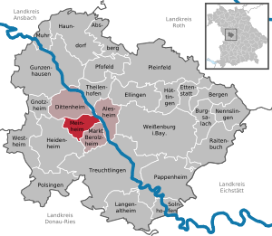
| Location of the community of Meinheim in the Weißenburg-Gunzenhausen district | ||
  |
||

Meinheim is a community with around 850 inhabitants in the central Franconian district of Weißenburg-Gunzenhausen and the seat of the Altmühltal administrative community .

geography
Geographical location
The community is located in the Altmühltal in the West Central Franconia region at the foot of the Hahnenkamm , a ridge of the Franconian Alb . The eastern border of the place is the Altmühl . The Meinheimer Mühlbach , which rises at the foot of the Dürrenberg three kilometers to the west, flows through the village of Meinheim . At the western end of the village it is fed by the Wolfsbronn Mühlbach . State road 2230 runs through the community . The community is mostly located in an open landscape characterized by meadows and fields, only the mountainous peripheral areas are covered with forests. Foothills of the Yellow Mountain as well as the Gemeindeberg and the Geißberg are located in the municipality . To the southwest lies the Steinerne Rinne nature reserve near Wolfsbronn , which, like the Steinerne Rinne in Oberweiler and the stream with sintering basin , is a geotope to the southwest of Wolfsbronn .
The neighboring communities are:
| Dittenheim | ||
| Heidenheim |
.svg)
|
Alesheim |
| Berolzheim market |
Community structure
The municipality has 9 officially named parts of the municipality (the type of place is given in brackets ):
|
|
history
Until the church is planted
Finds from the Bronze and Hallstatt Ages indicate a prehistoric settlement. Meinheim was first mentioned in a document in 1154. The Ansbach margraves acquired the possessions of the lords of Treuchtlingen and Holzingen in the 14th and 15th centuries . The place in what is now Middle Franconia belonged to the Principality of Ansbach acquired by Prussia in 1792 , and from 1500 part of the Franconian Empire . As part of Ansbach, it came to the Kingdom of Bavaria with the Treaty of Paris in February 1806 . In 1818 the political municipality was established.
Incorporations
On October 1, 1972, the previously independent community of Wolfsbronn and its districts were incorporated. Kurzenaltheim was added on May 1, 1978.
Population development
Meinheim is the second smallest municipality in the Weißenburg-Gunzenhausen district in terms of population.
- 1961: 908 inhabitants
- 1970: 876 inhabitants
- 1987: 788 inhabitants
- 1991: 809 inhabitants
- 1995: 832 inhabitants
- 2000: 892 inhabitants
- 2005: 879 inhabitants
- 2010: 851 inhabitants
- 2015: 842 inhabitants
coat of arms
The description of the coat of arms reads: "The silver church tower of Meinheim growing out of the lower edge of the shield, each side with a golden linden leaf."
Personalities who have worked in the place
- Georg Bickel (1862–1924), painter pastor
Architectural monuments
Geotopes

There are three designated geotopes in the municipality of Meinheim :
- The Steinerne Gully near Wolfsbronn (577R002), a designated nature reserve
- The stone channel southeast of Oberweiler (577R006)
- The stream with sinter basin southwest of Wolfsbronn (577R017)
Economy and Infrastructure
Economy including agriculture and forestry
In 1998, according to official statistics, there were no employees at work in the manufacturing industry or in the trade and transport sector. In other economic sectors 49 people were employed at the place of work subject to social security contributions. There were a total of 282 employees at the place of residence subject to social security contributions. There were seven companies in the manufacturing sector and two in the construction sector. In addition, in 1999 there were 57 farms with an agricultural area of 988 hectares, of which 765 hectares were arable land and 223 hectares were permanent green areas.
education
In 1999 the following institutions existed:
- Kindergartens: 50 kindergarten places with 48 children
- Primary school: 1st and 2nd grades of the school association Markt Berolzheim - Dittenheim -Meinheim
traffic
In the northeast, the state road 2230 runs from Gunzenhausen to Treuchtlingen past Meinheim, the district road WUG 34 leads to Wolfsbronn. The Würzburg-Treuchtlingen railway runs 1.5 km to the east .
literature
- Johann Kaspar Bundschuh : Meinheim . In: Geographical Statistical-Topographical Lexicon of Franconia . tape 3 : I-Ne . Verlag der Stettinische Buchhandlung, Ulm 1801, DNB 790364301 , OCLC 833753092 , Sp. 484-485 ( digitized version ).
- Gottfried Stieber: Meinheim . In: Historical and topographical news from the Principality of Brandenburg-Onolzbach . Johann Jacob Enderes, Schwabach 1761, p. 584-585 ( digitized version ).
Web links
- Entry on the coat of arms of Meinheim in the database of the House of Bavarian History
Individual evidence
- ↑ "Data 2" sheet, Statistical Report A1200C 202041 Population of the municipalities, districts and administrative districts 1st quarter 2020 (population based on the 2011 census) ( help ).
- ^ Community of Meinheim in the local database of the Bavarian State Library Online . Bayerische Staatsbibliothek, accessed on December 25, 2019.
- ^ Wilhelm Volkert (ed.): Handbook of Bavarian offices, communities and courts 1799–1980 . CH Beck, Munich 1983, ISBN 3-406-09669-7 , p. 477 .
- ↑ a b c Federal Statistical Office (ed.): Historical municipality directory for the Federal Republic of Germany. Name, border and key number changes in municipalities, counties and administrative districts from May 27, 1970 to December 31, 1982 . W. Kohlhammer, Stuttgart / Mainz 1983, ISBN 3-17-003263-1 , p. 731 .

Absberg | Alesheim | Mountains | Burgsalach | Dittenheim | Ellingen | Ettenstatt | Gnotzheim | Gunzenhausen | Haundorf | Heidenheim | Höttingen | Langenaltheim | Berolzheim market | Meinheim | Muhr am See | Nennslingen | Pappenheim | Pfofeld | Pleinfeld | Polsingen | Raitenbuch | Solnhofen | Theilenhofen | Treuchtlingen | Weißenburg in Bavaria | Westheim