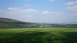
Kurzenaltheim
|
Kurzenaltheim
Community My Home
Coordinates: 49 ° 1 ′ 46 ″ N , 10 ° 47 ′ 17 ″ E
|
||
|---|---|---|
| Height : | 459–475 m above sea level NN | |
| Residents : | 166 (May 25 1987) | |
| Incorporation : | May 1, 1978 | |
| Postal code : | 91802 | |
| Area code : | 09146 | |
|
Location of Kurzenaltheim in Bavaria |
||
|
View of Kurzenaltheim
|
||
Kurzenaltheim is a district of the community Meinheim in the central Franconian district of Weißenburg-Gunzenhausen .
Geographical location and traffic
The parish village is surrounded by fields and meadows, on the edge of the Hahnenkamm, just under two kilometers west of Meinheim. The Meinheimer Mühlbach , a right tributary of the Altmühl , flows through it. The Yellow Mountain ( 628 m above sea level ) is located around two kilometers north-north-west . Municipal roads lead to Meinheim to the district road WUG 34 , to Wolfsbronn also to the WUG 34 and to the state road St 2384 near the Yellow Mountain.
history
In the geographical statistical-topographical lexicon of Franconia (1800) the place is described as follows: "Evangelical Lutheran parish village, two hours from the imperial city of Weissenburg in the Ansbach Oberamt Hohentrüdingen with 33 subjects belonging to it."
With the community edict (19th century) Kurzenaltheim became a politically independent community. As part of the regional reform in Bavaria , this was incorporated into Meinheim on May 1, 1978.
Architectural monuments
see also : List of architectural monuments in Meinheim # Kurzenaltheim
Population development
| year | 1910 | 1933 | 1939 | 1987 |
|---|---|---|---|---|
| population | 216 | 200 | 203 | 166 |
nature
Stone channel near Kurzenaltheim
West of Kurzenaltheim there is a stone channel about 30 meters long and up to 10 centimeters high . It is essentially deepened and its natural development is disturbed by human interference. Most of the moss needed for growth is missing. The hiking trails Frankenweg and Altmühltal-Panoramaweg lead past the channel . The channel is part of the FFH area of the eaves of the southern Franconian Jura .
The stone channel was vandalized in January 2018. The limestone trough was demolished over a length of around 15 meters and removed. It is now leaky in many places. Attempts were made to disguise the natural crime with a makeshift "repair".
Personalities
- Emil von Riedel (1832–1906), politician and lawyer
literature
- Siglinde Buchner: Kurzenaltheim - history of a former monastery-Solnhofischen village . Weißenburg in Bavaria 1996.
- Johann Kaspar Bundschuh : Kurzenaltheim . In: Geographical Statistical-Topographical Lexicon of Franconia . tape 3 : I-Ne . Verlag der Stettinische Buchhandlung, Ulm 1801, DNB 790364301 , OCLC 833753092 , Sp. 251 ( digitized version ).
- Gottfried Stieber: Retirement home (short) . In: Historical and topographical news from the Principality of Brandenburg-Onolzbach . Johann Jacob Enderes, Schwabach 1761, p. 193-195 ( digitized version ).
Web links
Individual evidence
- ↑ a b Association for Computer Genealogy e. V. , Kurzenaltheim
- ↑ Bundschuh, Col. 251
- ↑ Gemeindeververzeichnis.de , Gunzenhausen district office
- ^ A b Michael Rademacher: German administrative history from the unification of the empire in 1871 to the reunification in 1990. Gunzenhausen district. (Online material for the dissertation, Osnabrück 2006).
- ↑ Powerful places
- ↑ Vandal destroys "Steinerne Rinne" near Gunzenhausen , nordbayern.de, January 25, 2018


