
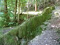
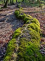
Stone gutter

The stone channel is the name given to the high bed of a stream near the spring in karst landscapes that is created by the precipitation of calcium carbonate (CaCO 3 , in this special case also known as spring lime ) .
Stone gutters (in Germany) rise up to 5.4 meters above the level of the adjacent ground and are up to 150 meters long. In Bavaria they occur preferentially on the southern edge of the Franconian Alb (geological Jurassic period ) and on the northern edge of the Alps. Stone gullies are often protected as geotopes (geological natural monuments ).
Emergence
Stone gutters are created by separating lime from leisurely flowing rivulets. For this purpose, carbonate-rich (lime-rich) water must emerge from a stratified spring and be able to flow off on a relatively gentle slope. There, the spring water releases part of the carbon dioxide dissolved in it through pressure relief, water heating and due to the extraction of carbon dioxide by plants, especially algae . However, the lime present in the water is dissolved as calcium hydrogen carbonate, i.e., which precipitates out again as insoluble lime (calcium carbonate ) after the removal of the lime after the following reaction:


The precipitated lime settles on the edge of the rivulet and forms the tufa that grows upwards (spring lime). In the colder water in the middle, this process is slower, so the channel is preserved. Since the lime precipitation continues, stone gutters can grow by one to two centimeters annually under favorable conditions. This process is interrupted by random disturbances, which may include falling leaves. The most impressive stone gullies were created with the support of human care, often for centuries.
Occurrence in Germany

Growing rock near Usterling

Stone channel near Erasbach , Berching
Stone channel near Wackersberg , Bad Tölz
Stone channel near Roschlaub , Scheßlitz community

Rinne Kuharsch, Krautheim (Jagst)


In Germany there is a high stone channel , the Growing Rock east of Usterling near Landau an der Isar . It is 37 meters long (according to official information; other information up to 50 meters), up to 5.4 meters high and has been tended by human hands for many centuries.
The Weißenburg-Gunzenhausen district , with six stone channels, is the district with most of these geologically rare natural phenomena. This is where - at Heidenheim - the longest stone channel is located at around 150 meters and - at Wolfsbronn - a somewhat shorter one at around 128 meters. See also the list of stone gutters in Bavaria .
literature
- Alfons Baier: The "stone channel" on the mountain south of Erasbach / Opf. An investigation into the hydrogeology and chemistry of the Shallow Karst . In: Geological sheets for northeast Bavaria and neighboring areas . Volume 52, No. 1-4, 2002, pp. 139-194 ( geol.uni-erlangen.de ).
- Wolfgang Voigtländer: A “stone channel” on the Baun-Alm near Bad Tölz. In: Yearbook of the Association for the Protection of Alpine Plants and Animals . Volume 32, 1967, pp. 86-93.
- VIB: Bricked by nature. On the Franconian Alb, streams flow through stone channels. In: Süddeutsche Zeitung , January 23, 2015, p. 46, Bavaria.
Web links
- Rohrbach on ingolstadt.de
- Environment Object Catalog (UOK) Bavaria Archive
Individual evidence
- ^ Bayer: The "Steinerne Rinne" on the mountain south of Erasbach / Opf. (see literature )
- ↑ Bavarian State Ministry for Environment and Health: Geotop 279R004 Steinerne Rinne near Usterling (Growing Stone). Environmental object catalog Bavaria archive.
- ^ Bavarian State Office for the Environment: Growing rock from Usterling. Bavaria's most beautiful geotopes.
- ↑ Geotope Steinerne Rinne Baum-Alm
- ↑ Geotope Steinerne Rinne S from Buckmuehle
- ↑ Geotope Steinerne Rinne Hechlingen
- ↑ Geotope Steinerne Rinne NW of Heidenheim
- ↑ Geotope Steinerne Rinne Knapp
- ↑ Geotope profile, Growing stream near Krautheim
- ↑ Geotope Steinerne Rinne Oberweiler
- ↑ Steinerne Gully Rohrbach
- ↑ Geotope Steinerne Rinne Rohrbach
- ↑ List of natural monuments in the Bamberg district (PDF; 24 kB) February 28, 2005, No. 60.
- ↑ Geotope Growing Stone in Schoenbrunn
- ↑ Natural monument Steinerne Rinne Wolfsbronn
- ↑ Geotope Steinerne Rinne Wolfsbronn