
Stone channel near Raschbach
|
Stone channel near Raschbach
|
||
 Stone channel near Raschbach |
||
| location | Raschbach , Altdorf , Middle Franconia , Bavaria , Germany | |
| surface | 2 ha | |
| Geographical location | 49 ° 25 ' N , 11 ° 23' E | |
|
||
| Setup date | 1997 | |
| administration | District of Nürnberger Land | |

The stone channel near Raschbach is a limestone tufa channel near Altdorf in the Middle Franconian district of Nürnberger Land in Bavaria .
location
The stone channel near Raschbach is located about 500 meters southwest of the Altdorf district of Raschbach . About 4.5 km further north there is another stone channel .
description
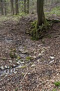
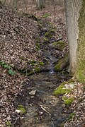
The channel is also called aster well . It is an approximately 30 meter long and up to 60 centimeter high moss-covered calcareous turf channel, the width of which is up to 20 centimeters at the top. As the lower slope becomes flatter, it becomes lower, narrower and then runs across the terrain. The total height of fall is around 5 meters.
The water rises from two smaller spring pots , which merge after about 10 meters to form a common stream. The shallow stream only reaches the actual stone channel after about 150 meters. On its way there it has formed some smaller sinter basins and then divides again at the beginning of the channel. The division into two seems to be more recent (as of 2014). The majority of the water flows down into the valley next to the actual channel and already produces some smaller sintered forms here as well.
The smaller part of the water flows into the original and moss-covered channel. The water runs away after about two thirds of the channel and no longer reaches its end today. Presumably, however, much more water originally flowed here and led to the growth of the channel.
The water then runs towards the Raschbach, which joins the Traunfelder Bach near Hagenhausen.
The area around the two springs and the channel is a designated and protected part of the landscape.
Emergence
Lime tuffs come in various morphological forms as large tufa beds, sintered terraces, tuff cascades or, as here, as limestone turf channels. Such channels are always tied to springs whose water has a particularly high lime content. Small, but constantly flowing springs, under favorable circumstances, create such stone gullies.
The groundwater cannot seep deeper here due to the underlying water-retaining layer of the regal clay and is directed to the side of the spring outlet.
The water temperature at the source fluctuates around 8 degrees. At the source outlet the water experiences a pressure relief, a mixing with the air and at the same time a change in the ambient temperature. Some of the carbon dioxide dissolved in the water escapes, causing lime to precipitate out of the water, which, favored by mosses and other plant parts, settles on the bottom of the channel. Certain algae are able to precipitate the lime dissolved in the water. The branched mosses then catch the precipitated lime. Algae and moss cause the upward growth of the stone channel on the initially flat sintered surface. The mosses find their best habitat on the edge of the stream bed in a damp and calcareous environment. In order to always get enough sunlight for their growth, they must always grow upwards or to the side out of the encrustation caused by the lime precipitation. The algae, on the other hand, prefer to live on the bottom of the flow channel; the solid lime deposited by them seals the channel downwards and to the side. In this way they ensure that the watercourse is channeled. As long as the water supply between the spring and the stone channel is not interrupted, it grows higher and higher, by a few millimeters every year.
Geotope
The channel is designated by the Bavarian State Office for the Environment (LfU) as an important geotope (geotope number: 574R027).
Access
The Raschbach stone channel is freely accessible all year round. It is hidden and can only be reached on foot via forest roads and forest paths. There is no signage.
The sensitive, porous tuff limestone must not be stepped on or destroyed. Above all, the channel must not be dammed up and the edges must not be broken. The growth of the porous limestone tuff would be permanently changed, the running of the fine channel would be impaired and further natural growth would be severely disturbed. If the water leaves the channel at any point, it will fall dry as it continues, and it will take a very long time until a new one is created on the new path of the water.
photos

Northern spring pot
Southern spring pot
Merging
Upper stream with sintered steps

Division of the stream

Water-carrying channel

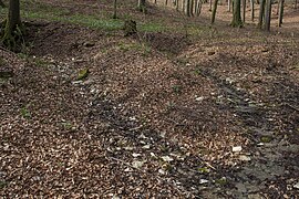
Dry fallen gutter


Web links
Individual evidence
- ↑ Location of the Steinerne Rinne in the Bavaria Atlas (accessed March 24, 2014).
- ^ City of Altdorf, Raschbach (accessed on January 23, 2017).
- ↑ Nürnberger Land, Ordinance Steinerne Rinne near Raschbach (accessed on March 20, 2020).
- ↑ Bavarian State Office for the Environment, Geotope Steinerne Rinne W von Schrotsdorf (accessed on March 21, 2020).