
Stone channel near Wolfsbronn
|
Stone channel near Wolfsbronn
|
||
.JPG) Stone channel near Wolfsbronn |
||
| location | near Wolfsbronn ; Middle Franconia , Bavaria ( Germany ) | |
| surface | 6.53 ha | |
| Identifier | NSG-00213.01 | |
| WDPA ID | 82630 | |
| Geographical location | 49 ° 1 ' N , 10 ° 47' E | |
|
||
| Sea level | from 495 m to 550 m | |
| Setup date | July 26, 1984 | |
| administration | Weissenburg-Gunzenhausen district | |

The Stone channel at Wolfsbronn is one of tufa existing Stone groove on the cockscomb . It is located near Wolfsbronn in the Weissenburg-Gunzenhausen district in Central Franconia .
Geographical location
The Steinerne Rinne is located in the Altmühltal Nature Park on the Hahnenkamm , part of the Franconian Alb low mountain range . It extends on the northern steep drop of the Lunkenberg ( 613.3 m above sea level ), the link between the Dürrenberg ( 656.4 m ) in the northwest and the Gemeindeberg (approx. 625 m ) in the southeast, about 500 m southwest of the eponymous Meinheimer Wolfsbronn district . The channel water flows into the Wolfsbronner Mühlbach , a south-western tributary of the Meinheimer Mühlbach , following a piping located below the channel .
description
The channel is a moss-covered calcareous tufa about 130 meters long and up to 160 centimeters high. The width of the base is up to 160 centimeters and the width of the top edge is up to 90 centimeters. The water rises above the spring horizon from a spring pot , which is located in a spring niche about seven meters deep. After about 30 meters of flat course, the stream leaves the source niche and forms the stone channel. The winding gully is broken by several smaller waterfalls. The dam itself rests on an arched tuff embankment. This is initially quite narrow and thin, but down the slope it becomes up to 60 meters wide and extends up to 8 meters deep into the earth. This largely invisible part was created over thousands of years through constant relocation of the stream bed.
As the lower slope becomes flatter, the channel becomes significantly lower, narrower and then runs across the terrain. After piping, the stream flows into the Wolfsbronn Mühlbach.
Due to the geological occurrence, diverse and rare flora, the area was designated as a nature reserve in 1964 and designated as geotope 577R002 by the Bavarian State Office for the Environment .
Despite its protective status, this channel is today more of a negative example. It was mostly artificially walled up as part of excessive tourist maintenance measures. In the middle part of the channel is interrupted by a forest path and the water is channeled into the other part of the channel with broken stones. In the lower part, the original route was probably redirected. As a result of these measures, the geological object is considered to have been destroyed and is only used for purely tourist purposes.
Emergence
Lime tuffs come in various morphological forms as large tufa beds, sintered terraces, tuff cascades or, as here, as limestone turf channels. Such channels are always tied to springs, the water of which has a particularly high lime content that it absorbed when it seeped through limestone . Small but constantly flowing springs create such stone gullies under favorable circumstances.
The groundwater cannot seep deeper due to the underlying, water-retaining layer of the regal clay and is directed to the side of the spring outlet.
The water temperature at the source fluctuates by eight degrees. At the source outlet the water experiences a pressure relief, a mixing with the air and at the same time a change in the ambient temperature. Some of the carbon dioxide dissolved in the water escapes, causing lime to precipitate out of the water, which, favored by mosses and other plant parts, settles on the bottom of the channel. Certain algae are able to precipitate the lime dissolved in the water. The branched mosses catch the precipitated lime. Algae and moss cause the upward growth of the stone channel on the initially flat sintered surface. The mosses find their best habitat on the edge of the stream bed in a damp and calcareous environment. In order to always get enough sunlight for their growth, they always have to grow upwards or to the side out of the incrustation caused by the lime precipitation. The algae, on the other hand, prefer to live on the bottom of the flow channel; the solid lime deposited by them seals the channel downwards and to the side. In this way they ensure that the watercourse is channeled. As long as the water supply between the spring and the stone channel is not interrupted, it grows higher and higher, by a few millimeters every year.
Access
Wolfsbronn's stone channel is freely accessible all year round. Below the state road WUG 34 from Wolfsbronn to Degersheim there is a larger parking lot, the access to the Steinerne Rinne is signposted. Immediately along the Rinnendamm there is a boardwalk with handrail, which after a few meters turns into a steeper ascent with wooden steps. This section is part of the long-distance hiking trails Altmühltal-Panorama-Wanderweg and Frankenweg .
Some information boards along the plank path introduce the stone channel and the ecology that is at home there .
Despite the considerable impairment caused by dam structures, the sensitive, porous tuff limestone must not be stepped on or destroyed, and the moss covering of the channel must also be left untouched. Above all, the channel must not be dammed up and the edges must not be broken. The growth of the porous limestone tuff would be permanently changed, the running of the fine channel would be impaired and further natural growth would be severely disturbed. If the water leaves the channel at any point, it will fall dry as it progresses, and it will take a very long time before a new one emerges on the new path of the water.
Flora and fauna
Liverworts , mosses , blue-green algae and tube algae are found in and on the channel . The channel and spring are the habitat of spring caddis flies and river fleas .
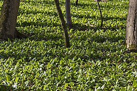
The area around the channel is of different orchids - and Luzulo - beech forests existed. In the lower area a large sedge-rich alder swamp forest spreads out. A swamp complex of fens and humid bushes grows in the vicinity of the spring outlets . Small open areas are occupied by low moorland rich in pipe grass with sedges , cotton grass and numerous orchids. In spring the wild garlic forms a large carpet around the spring .
photos

Source pot

The gutter

Artificial masonry with a dam

Interruption by a forest path

Artificially created elevation
Wild garlic carpet near the source


See also
- List of stone gutters in Bavaria
- List of nature reserves in Bavaria
- List of geotopes in the Weißenburg-Gunzenhausen district
Web links
- Natural monument Steinerne Rinne ... near Wolfsbronn (Gasthaus Steinerne Rinne ), on steinerne-rinne.de
- Nature reserve Steinerne Rinne near Wolfsbronn (Environmental Object Catalog Bavaria), on uok.bayern.de
Individual evidence
- ↑ Map services of the Federal Agency for Nature Conservation ( information )
-
↑ Location of the stone channel with the nature reserve:
- in the BayernAtlas , accessed on April 1, 2014, on geoportal.bayern.de
- in OpenStreetMap , accessed on April 1, 2104, on openstreetmap.org - ↑ W. Voigtländer u. a .: official display board at the foot of the Steinerne Rinne Wolfsbronn .
- ↑ Nature reserve 44 - Steinerne Rinne near Wolfsbronn , on regierung.mittelfranken.bayern.de
- ↑ Geotop Steinerne Rinne SW von Wolfsbronn , accessed on April 1, 2014, from lfu.bayern.de

Bird sanctuary shallow water and island zone in Altmühlsee | Alluvial forest near Westheim | Stone channel near Wolfsbronn | Bookkeeping at Markt Berolzheim | Schambachried | Dry Jura slope with the rock group "Twelve Apostles" | Oak-hornbeam forest Laubenbuch near Rothenstein | Spring horizons and grasslands on the Albtrauf near Niederhofen | Märzenbecherwald near Ettenstatt | Brombachmoor | Peninsula in the Kleiner Brombachsee | Reservoir root of Igelsbachsee | Sawmill | Grafenmühle