
Stone channel near Erasbach
Coordinates: 49 ° 8 ′ 3 ″ N , 11 ° 25 ′ 11 ″ E

The stone channel near Erasbach is a limestone turf channel near Berching in the Upper Palatinate district of Neumarkt in Upper Palatinate in Bavaria .
location
The stone channel of Erasbach is located about two kilometers south of the Berching district of Erasbach on the northern slope of the Erasbacher Berg.
description
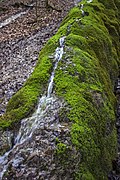
Erasbach's Steinerne Gully is an 80 meter long and up to 80 centimeter high moss-covered chalk tufa channel. The base of the gutter is up to 85 centimeters and the top edge up to 30 centimeters wide. In the flatter lower slope the channel becomes lower, narrower and flows towards the Erasbach, which flows into the Sulz.
Lime tuffs come in various morphological forms as large tufa beds, sintered terraces, tuff cascades or, as here, as limestone turf channels. Such channels are always tied to springs whose water has a particularly high lime content. Small, but constantly flowing springs, under favorable circumstances, create such stone gullies.
In the area between Erasbach and Berching at the Dogger-Malm border there are a noticeably large number of karst springs, some of which are relatively heavy. Since these springs all arise from the shallow karst, their carbonate-rich waters give rise to impressive tufa limestone deposits.
As with the Hohen Brunnen , which is about a kilometer away , the water here emerges from the limestone of the Malm over the ornate clay . The groundwater cannot seep deeper due to the underlying water-retaining layer of the regal clay and is directed to the side of the spring outlet. This, a spring pot, is popularly known as the French well , it is located at an altitude of 507.7 m above sea level. NN . It is assigned to the perennial (continuously pouring) karst springs . The spring discharge is around two liters per second, but can increase to up to nine liters after rainfall or when the snow melts. How the source got the name Franzosenbrunnen is not exactly known. According to tradition, French people who exchanged the water for food were stored near Berching in the 17th or 18th century during a period of drought.
Below the Franzosenbrunnens, the water does not cut erosively into the subsoil as usual, but rather its bed grows out of the surroundings due to the lime deposits.
The water temperature at the source fluctuates between 7.5 and 8.5 degrees over the course of the year. At the source outlet of the water it experiences a pressure relief, a mixing with the air and at the same time a change in the ambient temperature. Some of the carbon dioxide dissolved in the water escapes, causing lime to precipitate out of the water, which, favored by mosses and other plant parts, settles on the bottom of the channel. Certain algae are able to precipitate the lime dissolved in the water. The astmosses also precipitate lime by removing carbon dioxide from the spring water. Algae and moss cause the stone gully to grow upwards on the initially flat lime surface. The mosses find their best habitat on the edge of the stream bed in a damp and calcareous environment. In order to always get enough sunlight for their growth, they must always grow upwards or to the side out of the encrustation caused by the lime precipitation. The algae, on the other hand, prefer to live on the bottom of the flow channel; the solid lime deposited by them seals the channel downwards and to the side. In this way they ensure that the watercourse is channeled. As long as the water supply between the spring and the stone channel is not interrupted, it grows higher and higher, by a few millimeters every year. The subsoil of the Steinerne Rinne consists of tuff limestone to a depth of over a meter and a width of two to five meters.
The Erasbach Stone Gully is a very recent geological formation and only emerged from the middle of the last century. It is designated by the Bavarian State Office for the Environment as a geotope with the number 373R020.
Access
The stone channel of Erasbach is freely accessible all year round. The easiest way to get there is on foot via forest roads and forest paths. There is no signage. Since the porous tuff limestone is sensitive, the channel should not be entered. A damming up or a change in the upper edges can change the growth of the porous limestone tuff permanently. The course of the fine channel would be impaired and further natural growth severely disturbed.
photos

Source pot Franzosenbrunnen

Sinter stage

The high part of the gutter
Damage to the gutter


Individual evidence
- ↑ Location of the Steinerne Rinne in the Bavaria Atlas (accessed March 2, 2014).
- ↑ Geotope: Steinerne Rinne S von Erasbach (accessed on August 7, 2015).