Yellow mountain
| Yellow Mountain / Yellow Citizen | ||
|---|---|---|
|
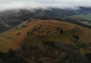
Yellow mountain aerial view from south |
||
| height | 628.4 m above sea level NN | |
| location | Dittenheim , Weißenburg-Gunzenhausen district , Bavaria ( Germany ) | |
| Mountains | Hahnenkamm , Franconian Alb | |
| Coordinates | 49 ° 2 '25 " N , 10 ° 45' 52" E | |
|
|
||
| rock | Rocks of the southern German Jura : in the summit area Malmkalk , Ornatenton and iron sandstone , at the foot of the mountain Amaltheenton and Gryphaeensandstein | |
| Age of the rock | law | |
The yellow mountain , also called the yellow burg , is 628.4 m above sea level. NN high mountain of the Hahnenkamm , a foothill of the Franconian Alb , near Dittenheim in the district of Weißenburg-Gunzenhausen , Bavaria ( Germany ).
Geographical location
The Yellow Mountain rises in the Altmühltal Nature Park on the northern flank of the Hahnenkamm 2.7 km southwest of the village church in the center of Dittenheim and 1.8 km southeast of that of the Sammenheim district .
Geology and Landscaping
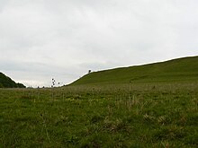
The Yellow Mountain, made up of rocks from the Jura , rises steeply from a glacial valley and consists of two superimposed, almost flat plateaus with an almost triangular floor plan. In the west , north and south the slopes drop abruptly steeply, only in the southwest there is a narrow, flat connection to the foothills of the Hahnenkamm.
history
General
The strategically located plateau of the Yellow Mountain served the people in different periods as a fortified settlement. It was used in the Urnfield Period from around the 10th to the 8th century BC. As well as in the late Hallstatt period in the 6th century BC. Fortified with walls. In the 4th century the mountain plateau was developed into a hilltop settlement of the Teutons with mighty walls up to 13 meters wide. At the end of the 5th century, when the Alamanni were subjugated by the Franks, the settlement of the Yellow Mountain ended.
see also yellow castle
The Yellow Mountain became known through archaeological excavations in the years 1908–1911 and 1926, which produced rich finds from different epochs. The majority of the finds date from the 4th and 5th centuries, only a few are younger.
In 1951, after the allied victorious powers lifted the flight ban, the Aviation Association Gelb Bürg was founded , which in 1958 moved to the area of the later built barracks in Heidenheim, just a few kilometers away. Today the club is based at the Gunzenhausen-Reutberg airfield .
Naming
The mountain is generally called the Gelber Berg, while historians and archaeologists tend to speak of the Gelber Bürg . The name Gelber Berg could come from the color of the iron sandstone of the mountain range, which has a striking reddish, but also yellowish color in some places. However, there is no historical evidence of this naming.
The earliest reliable mentions of the mountain come from the years:
- 1419 as a guarantee
- 1419 as a castle
- 1535 as a castle
- 1650 as a yellow citizen
The part of the name to give could be a form of the old male personal name Gebo and thus mean the castle of Gebo . The name Yellow Castle can therefore also be a further development from this name.
Protected areas
The Yellow Mountain is located in the extreme western part of the fauna-flora-habitat area " Trauf der Südlichen Frankenalb" (FFH No. 6833-371) and also belongs to the western part of the LSG protected landscape area, founded in 1995 and covering 3,141.36 km² within the nature park Altmühltal (LSG No. 329151).
Geotope
The Yellow Mountain is designated as Geotope 577R021 by the Bavarian State Office for the Environment . See also the list of geotopes in the Weißenburg-Gunzenhausen district .
Individual evidence
- ↑ a b map services ( memento of the original from December 19, 2012 in the Internet Archive ) Info: The archive link was inserted automatically and has not yet been checked. Please check the original and archive link according to the instructions and then remove this notice. of the Federal Agency for Nature Conservation
- ^ H. Eidam: A prehistoric fortification on the Gelben Bürg near Dittenheim. In: Correspondence sheet of the German Society for Anthropology, Ethnology and Prehistory. Vol. 43, 1912, p. 140.
- ↑ J. Werner: To the Alemannic castles of the 4th and 5th centuries. In: Speculum Historiale - Festschrift for Johannes Spörl. 1965, pp. 67-90.
- ^ Hermann Dannheimer: The Germanic finds of the late Imperial Era and the early Middle Ages in Middle Franconia. In: Germanic monuments of the migration period. Row A, 7 1962.
- ↑ Aviation Association "Yellow Citizens" Gunzenhausen - Club Chronicle
- ↑ Martin Winter: The Yellow Citizens in Franconian Times , Section The Name "Yellow Citizens"
- ↑ Geotope: Gelber Berg am Hahnenkamm (accessed on September 1, 2013)
literature
Martin Winter: The Yellow Citizen in Franconian times . In: Association for local history Gunzenhausen e. V. (Ed.): Alt Gunzenhausen . Contributions to the history of the city and the district. Issue 32, 1964, DNB 012612871 ( online ).


