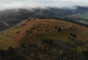
Yellow castle
| Yellow castle | ||
|---|---|---|
|
Aerial view from the south (2019) |
||
| Alternative name (s): | Yellow citizens | |
| Creation time : | before 1180 | |
| Castle type : | Hilltop castle | |
| Conservation status: | Castle stable, neck ditch, small remains of the wall | |
| Standing position : | Ministeriale | |
| Place: | Dittenheim | |
| Geographical location | 49 ° 2 '21.2 " N , 10 ° 45' 54.2" E | |
| Height: | 628.4 m above sea level NN | |
|
|
||
The Yellow Castle , also Yellow Bürg called, is a Outbound hilltop castle on the Yellow Mountain at 628.4 m above sea level. NN northeast of the market in Heidenheim in the Middle Franconian district of Weißenburg-Gunzenhausen in Bavaria .
Geographical location
The ring walls, known as the Yellow Citizens, are located on the Yellow Mountain, a mountain spur protruding from the Hahnenkamm to the northeast . The Yellow Mountain drops steeply to the west, north, north-east and south; in the east and south-west the rise is significantly flatter, so these were the critical points for securing the entire mountain plateau. On the lower plateau, set back an average of 100 m from the plateau edges, rests the steeply rising table made of white Jurassic lime . The upper plateau is roughly triangular in shape and measures 225 m from north to south and 275 m from east to west. It rises about 25 m above the lower plateau and is naturally protected on all sides.
Since the regional reform in 1978, the area has been completely located in the area of the municipality of Dittenheim .
history
Settlement of the mountain demonstrably began as early as the Neolithic . During the Migration Period there was a settlement on the Yellow Mountain . Little is known of the founding of the medieval castle and the course of its history. Around 1180 the castle was in the possession of the bishops of Eichstätt , in a document the Eichstätter Ministeriale Chono de Woluesprunnen is assigned an official seat.
Traces visible today
The upper and lower plateau were originally surrounded by ramparts on all sides . However, their state of preservation is very poor today. The southern wall of the lower plateau was heavily leveled over time by road works and agricultural use. A 20 m long part of the lower ring wall at the southwest end of the lower plateau is best to be seen today. From the outside the wall measures a height of 3.5 m, from the inside it is 1.6 m. Today there are two striking chestnut trees on this wall section .
The edge wall of the upper plateau fell victim to limestone mining at the end of the 19th and beginning of the 20th century. This initially took place on the steep slopes, but later also covered large areas of the interior. At the southern end of the west side, an edge rampart 1 m high and 10 to 12 m wide has been preserved. This point is probably a good measure of what was originally present on the wall on the upper plateau, because topographically this slope corresponds in its slope conditions completely to all other parts and therefore did not require any special protection.
On the eastern slope of the mountain there are still clear traces of a long-abandoned early high medieval fortification of the type of a ring wall . The castle stable still shows a neck ditch and fallen wall remains. In 1448 this castle stable is mentioned in the Heidenheim monastery register .
Archaeological finds
Among the Bronze Age finds are kerosene ceramics and a heart-shaped pendant. There are numerous finds from the Urnfield Period, including a fragment of a fire goat . From the Hallstatt period are fibulae before and painted pottery. Remnants of bricks and iron tools from the middle imperial period are believed to be of Roman origin. Buckles, belt fittings, bronze and silver brooches , remains of bone combs and a silver needle were found in Germanic finds from the late 4th to 6th centuries . Most of the finds come from collections in the 19th century, so that the exact location and circumstances of the find are mostly unknown. As a result, the finds do not provide an exact basis for determining the age of the ramparts.
literature
- Konrad Spindler (edit.): Guide to archaeological monuments in Germany, Volume 14: Landkreis Weißenburg-Gunzenhausen - Archeology and history . Konrad Theiss Verlag, Stuttgart 1987, ISBN 3-8062-0493-4 , pp. 168-175.
- Klaus Schwarz: Guide to Bavarian prehistory excursions, Volume 1: Limes - Karlsgraben - Yellow Burg - Hesselberg in the Ansbach area - Weissenburg - Dinkelsbühl - Michael Lassleben Verlag - Kallmünz 1962, pp. 54-64


